
Development design guide – urban myth and the Mahurangi
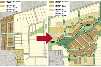
Rules or Outcomes: The examples in the draft document sometimes raise as many questions as they answer but in this example at least, the benefits of a more flexible, outcomes-based, approach is palpable. Rodney District Development Design Guide (second draft), Rodney District Council
Urban is an anathema to most folk associated with the Mahurangi.
So what, you may ask, has Rodney District Council’s draft urban design guide got to do with the Mahurangi catchment?
Surely, if it applies to anything north of the city of Auckland, it could only, at a stretch, apply to Ōrewa and its solitary high rise, the chronically despised, and currently incongruous, 12-story Nautilus apartment building!
But in the context of land use planning, urban, of course, is simply other than rural. Within the hydrological catchment, that mostly means Warkworth, as most urban land on the Mahurangi Peninsula drains into Kawau Bay, rather than the harbour.
While urban areas may only make up a small percentage of the catchment, their impacts are very significant. Urban areas contain a high ratio of hard surfaces that have the effect of concentrating stormwater, dramatically increasing its capacity to erode soils. During their development, they are particularly sediment-generating, but that is arguably a separate issue.
But urban design, even if neutral in its impact on sedimentation, is still of fundamental importance to the Mahurangi. Good urban design can contribute fundamentally to the health of communities. And even the most miserably misanthropic eco-obsessive must concede that a receiving environment will stand a better chance of being respected and protected, if the community upstream is healthy and happy!

Meshing with Mr Low Impact: Friends of the Mahurangi’s mission, illustrated with this cartoon, which it published in January 2007, fits very nicely with the concepts contained in the council’s draft urban guidelines to introduce low impact design. Mahurangi Magazine cartoonist Ross Kinnaird
Another reaction to the Urban Design Guide for Rodney District, particularly by those leaning politically towards less government, will be ‘Why would Rodney need its own, when we already have national urban design guidelines?’
It is a question that can be asked about much of the plan and rule writing that is done the length of Aotearoa, by one city, district, regional and/or unitary council after another. The extent to which New Zealanders consider these islands to be drowning in bureaucracy is bound to be vigorously ventilated when the Commission on Auckland convenes.
Ideological considerations aside, the guidelines are now in their second draft. The fact that they exist at all, and that the council boasts a senior urban design advisor (Andrew Trevelyan, who is responsible for the process) is a strong indication of the value placed in this tool. The clear signal to practitioners is, while these are guidelines only and not mandatory, follow them if you value the quiet life!
By having its own guidelines, Rodney can certainly ensure that local considerations are thoroughly addressed. In the Mahurangi catchment, that means a sharp focus on ensuring that the built environment is designed, to the greatest degree that is reasonably possible, to address the elevated sediment accumulation rate in the river and harbour.
Low impact design is the shining hope here. Its practices have been developed, from the ground—actually, from below the ground—up as a holistic approach to urban design. A garden that good urban design might have called for, might be a rain garden. Rain gardens are designed to retain and treat, in situ, vehicle-contaminated storm water, rather than flush it instantly into the nearest stream to overwhelm the natural fauna there.
Friends of the Mahurangi intends to make submissions and is keen to incorporate the views of members and non-members alike. Further, there is ultimately an opportunity for the group and other entities to become signatories to the urban design guide. Potentially, this device could make the document an extremely powerful tool, should the signatories include most of the practitioners in the resource consent, surveying, civil engineering, architectural, land development, building etc. field.
The census records Rodney District as the most populous district in New Zealand with 89 559 people and that which experienced the largest actual increase in population: 13 377 people since 2001. This itself is a strong argument for Rodney having its own guidelines, with its own committed group of signatories.
Andrew Trevelyan has taken the opportunity, given this is a non-statutory process, to provide a generous amount of time, the end of March, for feedback on the draft.
As curious as it might seem to the well-adjusted, there are going a number of people passionate about good urban design spending a significant portion of their Christmas vacation studying the Urban Design Guide for Rodney District, second draft.
Geographic footnote There is no Mahurangi West peninsula in the sense that it is increasingly used. The extremely tidal nature of Te Muri estuary means that the Cudlip Point peninsula struggles to qualify as commencing much before the eastern end of Ngārewa Drive. Not to put too fine a point on it, no part of the Mahurangi West Road is on a peninsula.