
Mahurangi Action Plan draft working paper: Landscape section
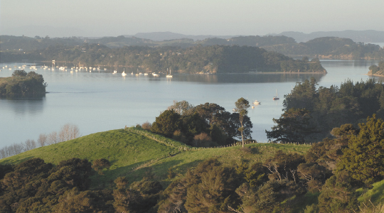
Landscape: The single most important issue the plan must address—a harbourscape of outstanding natural beauty and the first natural harbour north of the metropolis. The elevated sediment accumulation rate is reversible; realistically, loss of natural landscape amenity is not. Mahurangi Magazine Photograph Jonathan Barran
The following excerpt is the Landscape section of the draft working paper titled Integration. Editor
4.0 Landscape
As has been done with environmental issues addressed in earlier working papers, this section provides a discussion on the topic of landscape, the one remaining topic that has not been addressed in previous papers.
4.1 What is landscape
For the purpose of this paper, landscape is the visual qualities of an environment. Landscape values are considered to be a resource in their own right to be managed and enhanced to contribute to people’s amenity values and to secure attributes which have a positive outcome.
The landscape that we see is influenced by our own individual background and perceptions. People with an urban upbringing will see and experience rural landscapes or the relative wilderness of natural areas differently to the people who live within and make their living from the rural landscape.
All landscapes change. Landscape management should not be about how to ‘freeze’ a landscape in a particular state. It should always be about managing the type, direction and rate of change. An essential quality of a landscape management programme is that it identifies needs and opportunities to manage change. This requires an understanding of the dynamics of the landscape, the risks to that landscape, the aspirations of landowners and communities and the range and mix of management mechanisms and tools that are available.
It is important to understand how natural processes and human actions influence the landscape. These interactions influence the quality of the environment for people and nature. As the landscape is in a constant state of change, it requires appropriate and specific management to address issues that are particular and appropriate to place.
This change can be taken as an opportunity to intervene in a way which achieves beneficial outcomes for the catchment through proactive landscape management.
4.2 Legal and planning framework
Landscape management within the Mahurangi should occur within the wider planning policy set out at the national, regional and local scale. Existing policy documents define many of the landscape values and sensitivities of the Mahurangi. A selection of these is provided as Appendix 3. Existing plan documents (such as regional plans and the district plan) control and manage land use and its environmental effects, which in turn influence landscape values. Any additional actions within the Mahurangi catchment should recognise and not attempt to replicate or be inconsistent with this wider framework.
This framework includes:
- The Resource Management Act in particular the purpose and principles set out in Part II. This includes Section 6 (matters of national importance) including preservation of the natural character of the coastal environment and protection of outstanding natural features and landscapes; and Section 7 (other matters) including maintenance and enhancement of the quality of the environment and amenity values.
- The Hauraki Gulf Marine Park Act directs that regional and district planning documents authorities must give effect to it. It focuses on the interrelationships between the landward and seaward parts of the Hauraki Gulf (including Mahurangi) and the health and capacity of the Gulf as a whole.
- A key premise of the existing New Zealand Coastal Policy Statement is that visual impact of development is more acceptable in places where natural character has already been affected than areas which are not yet modified. The Statement is currently under review, and it could be likely that the revised version will require regional and district councils to go a step further and define (map) areas of high natural character and/or areas which are not suitable for development.
- The Auckland Regional Policy Statement addresses landscape and natural character values and identifies the high quality landscape areas within the Mahurangi Catchment along with natural heritage and cultural heritage areas. This policy framework sets a direction for managing growth within the region and therefore is particularly relevant to emerging landscape patterns.
- Planning Rodney: A District Growth Strategy identifies that urban Warkworth will accommodate its share of the District’s growth and that the rural areas of Mahurangi are generally intended to stay as productive areas or ‘green’ buffers.
- The district plan manages subdivision and land use. The district plan applies a range of zonings across the Mahurangi relating to the land use characteristics or objectives of the district plan and define the outcomes sought in these zones. Various controls are applied to development which affects its appearance (e.g. planting requirements), even development which is classed as a Permitted Activity. Assessment criteria also provide guidance on the types of environmental enhancement or mitigation which is appropriate to those activities or buildings which require a resource consent. This sets out a comprehensive framework for how the District Council controls and manages the potential adverse effects (i.e. visual impacts) of new development and/or land use change.
There are also other initiatives underway by councils, including the draft Rural Strategy for Rodney District, which focuses on management issues within the rural areas. This Strategy seeks to protect rural landscapes and rural character, and improve rural development outcomes.
4.3 Key players in landscape
Councils have a statutory responsibility to protect outstanding natural landscapes and features (Section 6, RMA) as well as the more general amenity values of landscape (Section 7, RMA). It is, however, landowners that have the ultimate responsibility for land management and the husbandry or stewardship of the landscape resource.
Key players in landscape include:
- Legal owners of land
- Responsible for the day-to-day management and development of land and thus its visual appearance.
- The general public
- Appreciate landscape values.
- The councils
- Statutory responsibility to protect special landscapes and to manage all land use and development.
- Mana whenua
- Ancestral and spiritual connection to the landscape.
4.4 Landscape issues
The purpose of this section of the working paper is to identify the issues (or problems) facing landscape in the Mahurangi Catchment and the relative significance of these issues. In this context an issue is anything which may undermine or threaten the vision and values for the Mahurangi Action Plan, as set out in the introduction.
In 2008 Boffa Miskell was commissioned by the Auckland Regional Council to undertake an assessment of the regional landscape resource as part of the 10-year review of the Auckland Regional Policy Statement. This assessment identified a number of regional landscape types and associated landscape management issues.
The Mahurangi Harbour Catchment falls within the Tawharanui-Mahurangi Peninsula and Sandstone Hill Country Regional Landscape Type (see Landscape Type Map in Appendix 2) for which the following key landscape management issues have been identified:
- Urban growth management of Warkworth particularly in relation to transport infrastructure and the alignment of SH1 and industrial and commercial land uses within sensitive upper harbour receiving environments. This reflects the ongoing development of Warkworth as a key strategic sub-regional growth area (managed by RDC proposed Structure Plan).
- Growth and urban form of existing coastal communities particularly south of Point Wells, west and south of Snells Beach and Algies Bay (managed by RDC Structure Plan adopted within District Plan).
- Residential development of isolated and prominent Mahurangi Harbour peninsula headlands.
- Enhancement and protection of areas of existing indigenous vegetation.
- Management of ongoing landscape change from coarse grained pastoral landscapes and related land uses with little residential settlement to finer grained, mixed use working landscapes incorporating horticultural and pastoral land uses and as well as rural residential living environments. This reflects the ongoing landscape transition from traditional extensive pastoral farming activities to a new cultural landscape characterised by a variety of mixed land uses.
Based on the above, and further investigation of other sources, the key issues for landscape are considered to be:
- Maintaining a quality rural landscape aesthetic.
- The design and visual and physical impact of rural and urban development including subdivision, ancillary roads, driveways and structures.
- Capitalising on opportunities for landscape protection and enhancement of positive landscape elements.
- The loss of the natural qualities of the coastal interface through coastal development.
- The quality of the visual and physical connection between the land and the harbour/water (e.g. Mahurangi River in Warkworth).
Some questions for you to consider are:
- What do you value about the existing Mahurangi landscape?
- How do you wish the Mahurangi to look in the future?
- What special public viewpoints do you know of and what are the threats to these?
- What change do you want to encourage and what aspects do you not wish to change?
The draft aims, objectives and actions for landscape issues have already been placed in the ‘integrating’ table later in [the Integration draft working paper] (see row titled Visual Character of the Mahurangi). Feedback on these issues, aims, objectives and actions can be provided as part of the integration exercise.
Christine Coste and Lisa Mein
Boffa Miskell
See also
Working paper: Integration
Working paper appendix: Appendix
Matrix: Draft Issues Matrix