
Subdivision and urban structure
Rodney District Development Design Guide
Part 3 Issues that affect all development types
Defining the use and ownership of space
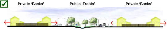
Organised: Users have little doubt over who is entitled to use which space. All activity is focussed towards public spaces offering the safest, highest amenity environments possible. Rodney District Development Design Guide (second draft), Rodney District Council
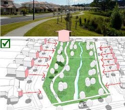
The clear definition of space between areas of private and public use is the single most critical element of functional built environments.
Aside from ‘like with like’ responses being an effective method of avoiding, remedying, or mitigating built environment effects, clear spatial delineation offers many positive effects.
Accentuating the relationship buildings have with streets and other public spaces offers the safest, most efficient and focussed settings for social exchange to occur. It also creates environments that are as legible, navigable, and interesting as possible for visitors. This will offer the most engaging treatment possible to public space edges and in so dong encourage the greatest non-vehicular use of those spaces (walking, playing, general recreating, cycling, and so on).
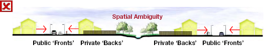
Disorganised: Users are less likely to use some parts of space due to poorly articulated ‘ownership’. Activity is diffused meaning that many public spaces are treated with poor interfaces, lighting, and so on. Safety and quality declines, as does the quality of social discourse. Rodney District Development Design Guide (second draft), Rodney District Council
The safest outcome is not always the intuitive one
Poor delineation of public and private space will not deliver these benefits and may unintentionally provide many opportunities for crime to flourish: a quirk of urban development is that seemingly safe environments may not be as safe as users assume.
Inferior: The private driveways shown here take as much space as a road except that there is no dedicated pedestrian or cycling space; no lighting for safe evening use; no opportunity for vehicle parking conveniently close to houses; and it requires the undesirable concentration of weekly wastes from many dwellings on the berm outside an unlucky neighbour’s property. Multiple individual driveways are also inefficient—they are permanently required yet only get infrequent use. Rodney District Development Design Guide (second draft), Rodney District Council
Many people feel that the safest environments are secluded, exclusive (often solidly fenced), and ‘off the beaten track’ away from busy routes and spaces where potential criminals using streets or public spaces can see in from and be attracted. In reality these settings often create the ideal circumstances for crime to occur due to a minimal risk of detection mixed with often homogenous land use patterns (such as residential commuter subdivisions that lie empty for most of the day).
Relevant to:
- District Plan?
- Long-Term Plan—Activity: Roading and Streetscape
- To be further developed
Environmental effects to watch out for include:
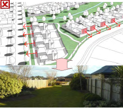
- Optimal street blocks are only two lots deep on their long side. The use of rear lots often creates unavoidable difficulties, compromising site amenity and creating practical overlooking / privacy problems.
- Rear lots are often provided to minimise the expense of creating more roads within a scheme. The requirement for driveways will typically overall require at least the same amount of physical space (although allocated differently). The only real difference is that the developer shifts property access costs to individual lot owners. Long driveways offer much lower amenities for residents and create practical servicing nuisances.
- Spaces that do not clearly communicate a sense of safe, lawful access to users will not be as efficiently used as spaces that do.
Responding to the coast, edges, waterways, and linkages
The connection between people and our coast, distinctive vegetation, landforms and unique waterways is a defining characteristic of our identity.
The retention and integration of these elements into a development is a key method of providing character and a sense of amenity for users. It is also one of the best ways of meaningfully improving ecological values and environmental protection. If done properly these will commonly combine to deliver higher, consistently stable property values over time for users.
Hidden: Natural feature hidden behind activity and fenced back gardens. Rodney District Development Design Guide (second draft), Rodney District Council
It is now common for development to ‘back’ onto these valuable features where they are typically fenced off (for the privacy and security of property owners); their value is reduced through poor interfaces along the edges; they become enclosed out of the public eye; and their accessibility to the general public is reduced. Another critical reason for incorporating such features into development relates to safety.
Development that provides good connections and ‘frontage’ to these features provides an opportunity for activity to result in the ‘see and be seen’ principle of natural surveillance. This has been demonstrated to be a successful crime deterrent.
Landscaping can enhance identity
Street trees should be provided on all roads with a species type reflecting local character and vegetation where appropriate. They contribute to micro-climate, pedestrian amenity and shade, identity, and are increasingly looked at in the context of climate change and potential carbon credits (or mitigation of the effects of vehicle emissions).
Careful species selection is important to ensure adequate passive surveillance and clean sightlines.
Relevant to:
- 7.14.3 Subdivision for the Protection of Natural Areas
- Long-Term Plan—Activity: Natural and Coastal Environment
- To be further developed
Exposed: Natural feature located where it enjoys the most exposure to activity. Rodney District Development Design Guide (second draft), Rodney District Council
Environmental effects to watch out for include:
- Retained flora contributes to habitat, improving biodiversity, and amenity for residents and users.
- Careful species selection having regard to crime avoidance principles (such as ensuring dense foliage located above eye level) improves safety for users of features by ensuring they are within sight of activity and other people.
- As areas intensify and ‘infill’ over time, the loss of vegetation can place significant pressure on street trees and vegetation in reserves to serve as the only available biodiversity corridors for many birds and other fauna. The species-selection of street trees should accordingly reflect an appropriate consideration of this function.
- Poorly integrated features will be less used. This loss of potential activity represents an inefficiency that is an effect on the community’s social and economic well-being.
- Effective pedestrian-friendly environments help reduce vehicle use, emissions, and congestion on roads.
A guide to the guideline
- Urban design as a way to balance all interests
- Sustainable management in Rodney
- Issues that affect all development types
- Site analysis and response
- Subdivision and urban structure: pages 7–8 [This page]
- Transport and movement
- Issues that affect specific development types
- Residential
- Coastal development
- Town centres
- General employment land
- Case study examples—before and after
- Peripheral residential
- Typical residential
- Mixed density urban residential
- Shopping centre
- Large-format retail
- Office park
- Committing to quality
- A appendix—implications for resource consents
Further reading
There is a wealth of information available on detailed design elements. Instead of repeating them, this guide will focus on the primary ones relevant in Rodney. Sources of further information will be referenced where relevant throughout but in an overall sense the following are key sources:
- People+Places+Spaces: A Design Guide for Urban New Zealand; Ministry for the Environment, 2002
- New Zealand Urban Design Protocol; Ministry for the Environment, 2006
- Associated Urban Design Protocol documents; Ministry for the Environment, 2006–today
- National Guidelines for Crime Prevention Through Environmental Design in New Zealand; Ministry of Justice, 2006.