
One trail to demonstrate them all
Corrected 24 February 2013
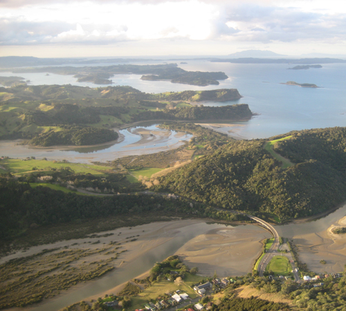
Low-Hanging Public Transport Park Access: The adjoining 900-hectare Wenderholm and Mahurangi regional parks represent the lowest of the low-hanging fruit potentially accessible by public transport. Waiwera, foreground, already has an hourly service to midtown Auckland, with the express buses taking a mere 67 minutes. Most regional parks are accessible only by private transport, and have only low prospects of public transport access in the foreseeable future. image ImageShack
It may be because the landscape resembles a South Seas Lake District.
Or it may simply be a universal urge, but locals have long dreamed and talked of creating a network of trails in the harbourscape of outstanding natural beauty that is the Mahurangi. An hour-and-seven-minute express bus ride from downtown Auckland, regional parks extend into and across the harbour heads, potentially placing the Mahurangi–Matakana wine district within half a day’s walking and cycling distance of the metropolis.
Dreams of this scale could have been realised through a number of opportunities, and deserved to have become a recognised civic goal decades ago, when 83% of respondents said they wanted a network of walkways to be well established within 25 years. In the event, 21 years on, even the 41% who ventured that they thought a network of walkways would be well established within that timeframe, were overly optimistic.
Fast-forward to 2012, and the Mahurangi comparison of the establishment performance of open-ground vs. container-raised indigenous plants, forerunner of Tāne’s Tree Trust’s Lake Taupō Protection Trust trials. The Mahurangi plants were being painstakingly measured for a second time, with every expectation of seeing similar pattern to that revealed by the first measurements, taken in 2009 after the plants had been established a year. This showed the open-ground plants to be significantly more cost-effective than their more expensive container-raised cousins. The indigenous forestry field technician and his assistant began speculating about future uses for the planting site, belatedly realising that there was potential for a second phase of trials, and the possibility of extending the work along an adjoining broad riparian margin that had been planted four years earlier but, in contrast to the trial site, was rather sparsely established. A meeting with property-holder Shelley Trotter suddenly put the proposal in a new light. One of the areas suggested for additional planting was in fact an area that had deliberately been kept open, as a potential parking area for Shelley’s dream of a walkway connecting the Mahurangi and Matakana wine growing areas, and eventually linking local settlements, including Snells Beach.
And so the Mahurangi Farm-Forestry Trail was conceived. Not only would the trail assist in the creation of a comprehensive demonstration of exotic and indigenous farm forestry, the farm-forestry trail would establish a precedent for the larger network of cycle and walkways, whereby it could become one vast extended showcase for sustainable land use options.
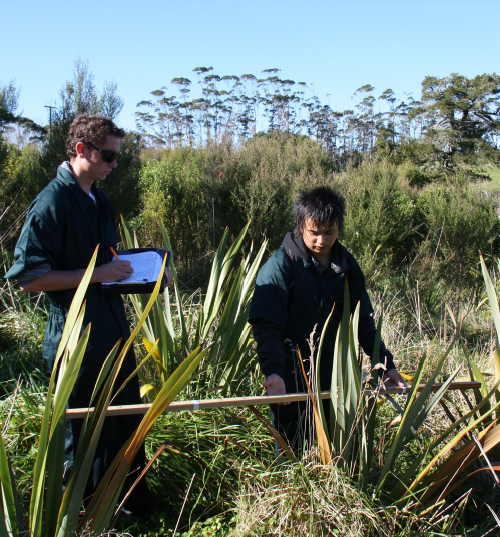
Gateway to a More Cost-Effective Future: In Aotearoa’s first-ever scientifically designed comparison of the establishment performance of indigenous plants raised in open-ground nursery beds and those raised by the usual horticultural methods involving planter bags, pots or root trainers, the open-ground, or forestry-style, method proved to be significantly more cost-effective. Here Rodney College students enrolled in its inspirational Gateway work experience programme spend a day measuring some of the more than 6000 remeasured in 2012. photographer Michael Bergin
Because the trails will often follow rivers and streams, there will be considerable opportunity to showcase a range of riparian protection regimes. This is particularly relevant in the Mahurangi catchment, given the harbour’s elevated sediment accumulation rate. Before being subsumed by the new Auckland Council, the regional council had undertaken a five-year, $3 million programme of riparian margin protection, so dire were the results of 10 years of studies of the harbour’s benthic communities. In the 1991 questionnaire alluded to earlier, 38% of respondents expected siltation to have increased substantially, with only 18% expecting a reduction, as a result of better land-use practices; a quarter expected it to be about the same. Few, however, would have guessed that the science was about to show that, in some areas studied, the likes of cockles and horse mussels were becoming so stressed that they had completely ceased breeding.
Despite more than 120 kilometres of riparian margin being protected and 40 farm plans being completed under the Mahurangi Action Plan, the harbour faces an increasing threat of sediment generation, thanks to global warming. The Ministry for the Environment warns that, in Warkworth, average annual rainfall is likely to decrease by 3% by 2040 and 5% by 2090, but that the intensity of ex-tropical cyclones is likely to increase and that when these occur there will be an increased risk of damage from heavy rain and strong winds.
Whether it is to protect riparian margins or to increase tree cover generally, the Mahurangi catchment needs at least nine million plants and trees to be established—an arbitrary 10% of the catchment. At the price typically paid for indigenous plants, this is clearly unaffordable. But rather than take the position that every little bits helps, the help of Dr David Bergin and Jaap van Dorsser was sought to kick-start open-ground, or forestry-style, production of indigenous species. Restart, of course, is the more accurate verb, in that Jaap van Dorsser had, in the 1960s and 1980s, successfully adapted forestry nursery practices for the large-scale production of indigenous species. The first step was to demonstrate the superior cost-effectiveness of open-ground raised plants. That site, serendipitously, will now connect the main Mahurangi–Matakana cycle and walkway route half a kilometre to the popular Parsley Pot café, situated busy Sandspit Road, midway between Warkworth and Snells Beach.
The initial Mahurangi Farm-Forestry Trail follows Duck Creek a distance of 1.1 kilometres. The stream’s name belies its beauty—tōtara-shaded, running clear over a bed of sandstone. The Mahurangi Action Plan had earlier focussed on building a coalition of the willing, and Shelley Trotter farms deer and beef on 265 hectares of the Duck Creek sub-catchment of the Mahurangi, the fourth generation of her family to farm there. An environmental scientist and geographer, Shelley completed her master’s thesis on historical sedimentation rates in the Mahurangi. Even before the action plan was launched in 2004, Shelley was dedicated to fencing and planting the riparian margins of her farm, a job begun by her father when she was still a child. With regional council funding, the areas retired could now be planted in indigenous species. Shelley’s other passion, meantime, is for cycle and walkways, and bridal trails. A measure of that passion is that when a property key to providing public access between ‘her’ section of Duck Creek and the Mahurangi River, a winery, came onto the market, she and her partner, Gary Heaven, bought it. It helped that Gary had harboured winemaking aspirations, but that consideration was in fact secondary to the walkway access imperative.
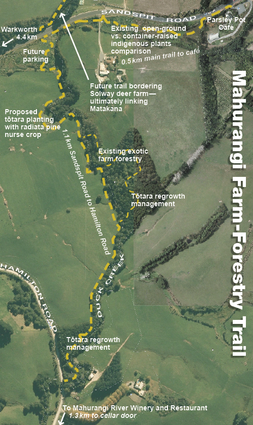
Thirty-Minute Walk or Lose an Afternoon: The 1.1-kilometre walk alongside Duck Creek, plus the half-kilometre branch trail to the Parsley Pot café can be covered comfortably in half and hour. But to do justice to the points of farm-forestry interest, much less to include a picnic beside the clear-running stream, demands an hour or more. map Mahurangi Magazine aerial images Auckland Council GIS Viewer
Thanks to Shelley long being a farm-forestry adherent, the trail already boasts of many stands of exotics: Eucalyptus pilularis; Eucalyptus muelleriana; Pinus radiata GF25; Pecan grown from rootstock trees from Paroa Bay; chestnuts, grown from nuts, but selected for timber growth rather than nuts. Also on the trail there are also ornamental swamp cypresses, a couple of Andean cherries, grown for timber, and a shelterbelt of Cryptomeria japonica. All are circa 18 years old.
Incredibly however, the existing farm forestry is not confined to exotic species. Two separate stands of totara regrowth border the stream, providing the perfect opportunity to demonstrate, for the first time in the Auckland region, the management of naturally regenerating indigenous species, as pioneered by the Northland Totara Working Group. Work has already commenced on the more accessible of the two stands, which lies immediately beside Hamilton Road, en route to the Mahurangi River Winery and Restaurant. Two circular, permanent sample plots have been established and measured, one for thinning and one to serve as a control. In similar trials in Northland, trees in the thinned stands have quadrupled their growth rates within the first year. It is all about providing the canopies of the trees retained with more space. Because its canopy is a tree’s ‘engine room’, it is as though the tree has been given a bigger engine, as the canopy grows to exploit the extra space made available. Rather than a desperate struggle to keep pace with its lanky cohort, the tree can also invest in girth, greatly to the saw miller’s merriment, if sustainable timber production is the goal. But even if done for non-extractive purposes, the result is greater biomass, greater carbon-sequestration, and greater biodiversity in the understory, and in the canopy, for that matter.
To the untrained eye, stands such as the two on the Mahurangi Farm-Forestry Trail resemble remnants of the original indigenous forest. On closer inspection, however, it can be seen that all the stems fall within a range of diameters that suggest that they are of a similar age, in this case possibly in the order of seventy years. Ultimate proof will come at the thinning stage, once sample disks extracted have been expertly dated. If indeed the age-range is not great, and not nearly as great as the difference in diameter might otherwise suggest, it can reasonably be assumed that the stand has naturally regenerated.
Measuring and management of these first two plots has been enabled by a $2000 grant from the Rodney Environmental Education Fund and fieldwork heavily subsidised by Environmental Restoration, a consultancy involving experienced indigenous forestry field technician Michael Bergin. It has been timed so as to be ready to demonstrate management of tōtara regrowth to attendees of the New Zealand Farm Forestry Association’s National Conference in April, based nearby in Ōrewa. Further funding of $8280 from the Rodney Local Board, confirmed at its Monday meeting, will allow the Parsley Pot café to Duck Creek section of the trail to be established, including entranceways and interpretive signage. However, despite pulling out all the stops so as to have key components of the farm-forestry trail ready for viewing, space could not be found by the conference organisers in the three days of scheduled field trips for a four-and-a-half-kilometre diversion. Consequently, a walk of the trail will be take place on the fifth day of the conference, Wednesday 24 April, when a number of optional field trips will be on offer. The field trip will begin with coffee at the Parsley Pot café at 9.30 am, and will culminate with a demonstration of tōtara thinning at 11am. Two major funding applications have been made, to the Sustainable Farming Fund and the Air New Zealand Environment Trust. If the former is successful, the exotic and indigenous farm forestry component, and the associated science, can be undertaken, beginning this financial year. If the latter is successful, the cycle and walkway infrastructure can be built and the trail officially opened.
Funding applications are generally something of a lottery. But it helps, particularly with the Ministry for Primary Industries’ sustainable farming and forestry fund, for a project to have and strong community of interest of organisations with good track records, high-calibre personnel and strong local and national coverage. The Sustainable Farming Fund application is jointly in the names of Mahurangi Action Incorporated, established in 1974 as Friends of the Mahurangi, and Tāne’s Tree Trust, as the legal entity that would be contracted with the fund. Aside from its unparalleled experience and expertise with indigenous forestry, Tāne’s Tree Trust has the operational and financial experience to manage a $340 000 project that the local group lacks. It also helps that the participating organisations, which include the New Zealand Farm Forestry Association, have undertaken to make both cash and in-kind contributions, to the extent that the fund is only being asked for $213 400.
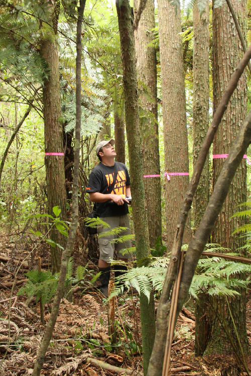
Northland-Style Indigenous Demonstration: For the first time in the Auckland region, the Mahurangi Farm-Forestry Trail demonstrates the management of tōtara regrowth techniques pioneered by the Northland Tōtara Working Group. Here Michael Bergin pauses after carefully measuring every tree and shrub on two circular, one-twenty-fifth-hectare plots. One plot will remain unmodified as a control, whereas the other, after judicious thinning, will possibly see girth growth-rates quadruple. NB Pink tape on trunk is for identification only—it does not indicate a particular tree is to be removed. photographer Cimino Cole
The project appears to be a perfect fit for the Air New Zealand Environment Trust, the criteria of which includes accessibility of the project to the public, and value to sponsors and tourism, and states that the project should engage New Zealanders. The highly regarded trust is part of why Air New Zealand is a finalist in this year’s global Tourism for Tomorrow Awards. Even if the company is not amongst the four 2013 award winners, it is already in salubrious company—the Jane Goodall Institute Uganda was 2011 finalist. Bizarrely, Air New Zealand’s achievement appears to have been completely ignored by the media, and not just by the mainstream. Although none of the applicants has had experience with the trust, it is hoped that a successful outcome with the Sustainable Farming Fund—decisions will be communicated mid to late February—will enhance the project’s prospects.
Contrasting with the managed regrowth plots, will be a number of new plantings of tōtara, demonstrating various promising establishment regimes, including the use of radiata pine as a nurse crop. It is likely that these planted trees will, in four decades, have an average girth similar to the seven or so decade-old regrowth trees that have just been measured. But not only tōtara will be planted, other indigenous conifers such as rimu, kauri and tānekaha, as well as indigenous hardwood timber trees such as pūriri, rewarewa, kohekohe and pōhutukawa are likely to feature.
Unsurprisingly, given the genesis of the project, open-ground stock will be used where possible. The exception will be kauri, which Jaap van Dorsser found to respond poorly to the mechanical roof pruning that is integral to forestry-style nursery methods. All other commonly indigenous species establish well from open-ground transplants, even notoriously root sensitive mānuka, provided it is planted sufficiently early in the season to be guaranteed to not dry out. One late-season planting of open-ground plants in the Mahurangi resulted in close to 100% failure of the mānuka involved, but good survival of the other species—harakeke, karamū, koromiko, tī kōuka (cabbage tree) and toetoe.
Between 350 000 and 600 000 hectares of steep, erosion-prone grassland nationwide could benefit from afforestation (Davis et al. 2009). While the Mahurangi catchment may not display the egregious examples of erosion seen on the East Coast, its tidal prism (flushing volume), in relation to its catchment is such the much of the sediment accumulates within the harbour, rather than being flushed out to sea. Ironically, considering the cause of heavier rainfall events responsible for the bulk of soil loss—global warming—the sediment accumulation rate is currently keeping pace with sea-level rise. The future, inevitably, will see a muddier shoreline, which is why it urgently needs as much protection as possible, from the large-scale planting of appropriate species.
If the Sustainable Farming Fund declines to partner the Mahurangi Farm-Forestry Trail, it will still deserve credit for enabling the open-ground component that has sparked the beginning of a project with the potential to become a national indigenous forestry showcase.
With more than $10 000 funding from Auckland Council even ahead of the financial year the project was to begin, the dream is becoming the reality.
See also Open-Ground Indigenous Plants Report
It seems likely that the Mahurangi catchment will experience more frequent high rainfall events. Riperian protection and farm forestry are ways to make the catchment more robust. A robust catchment will buffer those high rainfall events and give us a better chance of clean floods. Clean floods may even help flush new sediment out of the harbour. Clean floods are the only way to effectively increase the tidal prism and thus improve navigation, without expensive dredging.