
Jade River: A History of the Mahurangi
Ronald H LockerFirst published 2001. Published online 2014–. This online edition is a work in progress…
Pages 6–8in printed edition
Laying the foundations of a harbour

So Far So Good: Dr Ronald Locker’s potted history of the geological past of Aotearoa is sound in respect to its foundation as part of Gondwana. This depiction replaces that originally published in Jade River : A History of the Mahurangi, which, aside not being in colour or showing the origins of Zealandia, used the perhaps purer but now comprehensively superseded name Gondwanaland. Locker used Gondwana. image GNS Science
Rocks exposed in the cliffs of the Mahurangi Harbour, in the highest road cuttings on Schedewys Hill, and even on the summit of Mount Tamahunga at 438 metres, are the familiar Waitematā sandstones.
Clearly, they are extensive and thick, but they are not old. Much older stuff lies beneath. This basement, shared with most of the country, is an appropriate place to begin the story of the Mahurangi.
The oldest rocks in Aotearoa date back 680 million years, to a time when Aotearoa was largely sea floor off the coast of the super-continent Gondwana. These rocks and their successors have been shunted to the West Coast of the South Island and need not concern us further. It was the laying-down of the rocks, known as the greywackes, that provided the foundation of Aotearoa. This was but a small episode in the global process of continental drift. Not long ago, scientists saw this concept as the pipedream of a few slightly mad colleagues, but since the late 1950s it has passed from notoriety to acclaim, as evidence has piled up in its favour. The new science of plate tectonics has become the great unifying principle of modern geology. The new wisdom is that the landmass of the planet was once joined into two great super-continents which subsequently fragmented and drifted apart. One of these, Gondwana, contained South America, Antarctica, Australia, India, and Africa.
Editor’s note: Far-more-fascinating foundations
While Dr Ronald Locker’s description of the foundations of Aotearoa in the following five paragraphs is broadly in line with geological orthodoxy, an even more fascinating understanding was only just emerging as Locker was completing his history of the Mahurangi. This is the story of the largely failed continent of Zealandia, including the fact that Aotearoa arose from the sea like Aphrodite, as Locker lyrically suggests in the introduction to Part 1, but for a second time far more recently, and possibility after being entirely submerged. For those unfamiliar with the story of this stretched-too-thin continent, on the strength of In Search of Ancient New Zealand, 2011, the editor recommends Zealandia: Our Continent Revealed, 2014, both co-authored by Hamish Campbell.
Laying the Foundations continues…
More than 260 million years ago, on the edge of Gondwana that we now know as the east coast of Australia, the sea floor was being forced down beneath the continental shelf by the spreading of the ocean floor. (A process driven by the upwelling of basalt along the mid-oceanic ridges). The stress induced in the down-warped oceanic crust gave birth to a line of offshore volcanoes. On the landward side of these volcanoes, the seabed accumulated the debris from the shore, mixed with volcanic material. On the seaward side, the moving sea floor rafted in granitic material, deposited from the erosion of the mountains of Marie Byrd Land in Antarctica (then much closer). This material also arrived peppered with the output of the volcanoes. The whole of this accumulation was compressed against the coast of Gondwana. Such continental material is less dense than the basalts of the ocean floor, and resisted being thrust down with the oceanic plate. It was forced upward instead. So occurred our most notable mountain-building event: the Rangitata uplift, creating the present alpine backbone of Aotearoa. Julius von Haast, Provincial Geologist of Canterbury, could look out on a clear day from Christchurch to the Torlesse Range. It was he who named its substance the Torlesse rocks, and classed it as greywacke, a German term for a hardened sandstone or mudstone. His geologist successors realised that the Torlesse rocks form not only the alps of Canterbury and Marlborough, but extend through the North Island. Greywacke outcrops in the eastern King Country and Waikato, and on both sides of the Firth of Thames. In Northland it emerges along the eastern coast, but is buried to the west. Northward from Canterbury to Northland, the greywackes become younger, decreasing in granitic components but increasing in volcanic content.
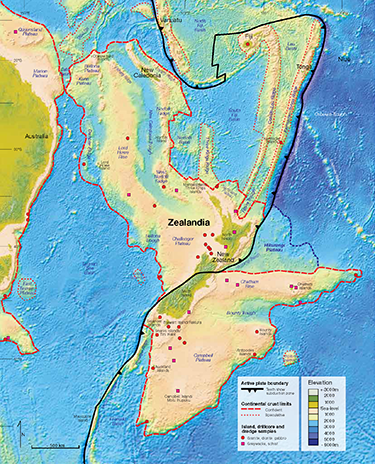
Far-Flimsier Foundations than First Thought: Given that the continent of Zealandia was stretched so thin it sank beneath the ocean, it is only thanks to subsequent particularly energetic tectonic plate collision that a significant landmass, sufficiently thick, materialised as Aotearoa. The earlier hypothesis that a ‘Moa’s Ark’ majestically sailed away from Australia with much of its flora and fauna intact has had to be revised—much, if not all of Aotearoa’s indigenous species have arrived relatively recently. image Zealandia: Our Continent Revealed
At Mahurangi, the line of emergence runs through Whangaparāoa Passage and Kawau Bay. Tiritiri Matangi Island, the islands of the Motuketekete group, most of Kawau Island, and the end of Tāwharanui Peninsula all lie in the greywacke. Motuora, the Saddle, the Mahurangi Peninsula, the harbour and hinterland lie in the Waitematā sandstones, below which the greywacke is buried. The interface of greywacke and sandstone is also seen in most of the Hauraki Gulf islands to the south. It is hard to imagine that the gentle landscape of the harbour sits on a base owing part of its parentage to Antarctica.
Volcanic intrusions into the greywacke at Kawau, modified by subsequent hydrothermal activity, produced the copper ores there. The same process also concentrated manganese, which was the interest of the first mining company—manganese dioxide is the jet-black material commonly seen on minor fault lines in the rocks.
Greywacke is one of our most valuable materials in its own right as an aggregate for roadmaking or concrete. In the twenties and thirties, the headland of Motutara was worked as a quarry by Public Works using prison labour, and later by McCallum Bros.. The headland has been quarried away. The first metal roads around Waiwera were made in 1928–9 of this material, barged in. Greywacke pebbles from the beach on the island, also served to grind cement in the tube mills at the works. The greywacke beach at Waikauri Bay on the southern shore of Tāwharanui was a popular source of shingle with the scowmen. The shingle was loaded at first with barrows, and in later years with diesel loaders from bins. Yachtsmen should take note of the different geology here. I once attempted to anchor in the bay. The usually trustworthy Danforth anchor skated uselessly over the polished pebbles, calling for a hasty change to a pick anchor.
The Tasman split
It was predestined that we were not to be part of Australia. About 80 million years ago a crustal crack developed between Gondwana and the debris piled against it. Basalt welled up in the crack and sea floor spreading began there in opposition to the general movement of the Pacific plate. The Tasman Sea was born and continued to widen for the next 20 million years. Then, 60 million years ago, movement ceased, and Aotearoa stood in its present relationship to Australia. Closer geological relations with Australia were at an end. A new phase of seafloor spreading then began, 55 million years ago, when Antarctica began to separate from Australia, opening up the circum-global Southern Ocean. Australia and Aotearoa, as part of the Indo-Australian plate, were rafted northwards. Aotearoa now lies precariously across the boundary of the Indo-Australian and Pacific plates. To the north the Pacific plate is being forced below the other, and to the south, over the other. Cook Strait is a kind of crunch point. We can expect no respite from earthquakes.
Coal measures and limestone
During the drifting apart of Aotearoa and Gondwana, our new and mountainous land was being levelled by erosion. Some of the debris stopped short of the ocean, creating swampy lowlands. Here plant debris accumulated as peat, destined in time to become coal. The swamps were then invaded by the sea. As the hills rounded off, the supply of silt diminished and the main source of sediment became the lime-rich remains of marine creatures, flourishing in the shallow seas. Thus, was set up a typical sequence of strata: coal beneath siltstone, capped with limestone. In the South Island such strata were laid down while the Tasman was still widening, but in the North Island later, from 50 million years ago.
The eastern part of the North Island was then already under the sea, and coal was laid down on its western edge. The coal measures and their limestone cover are named the Te Kūiti Group, after the district where they are so conspicuous. These rocks were laid down between 45 and 35 million years ago. The series extends through Northland. In places it has been shuffled about or even overturned, and often stripped away by erosion.
In a few places on the Mahurangi River the Te Kūiti group is exposed near sea level. Here the strata survive, in correct order and sitting, as they should, on the greywacke bedrock. ‘Own Correspondent’ in 1876 surmised of Mahurangi:
We have limestone and ironstone in abundance, and I do not see why we should not have coal. Several geologists state that there is abundance of coal in the district, at no great distance from the surface. Mr Wright, a well-known geologist in Australia, visited in 1853, and stated that Mahurangi was nothing less than an immense coal basin, and the coal near the surface. He was to apply to the Government for boring-rods and assistance, which was done, and we were answered that there were no available funds.
Weekly News 12 August 1876, abridged
Four years later, hopes were apparently vindicated. On 25 May 1880, the Weekly News announced ‘The Coal Discovery at Mahurangi’. A public meeting at Warkworth, ‘one of the most important ever held in this district’, was presided over by the Reverend McKinney. He was one of several settlers, on whose land outcrops of coal were found. A mining engineer, Mr Moody, announced his favourable impression of the indications around the district, and his intention to explore the field fully. The meeting discussed the best means of developing this new coalfield. Reports kept appearing regularly in the press. It was proposed to borrow the Government’s diamond drill. My last relevant clipping (Weekly News 4 June 1881) reports the fortnightly meeting of the Mahurangi Coal Prospecting Company with H Pulham in the chair, and Reverend McKinney, N Wilson, C Thompson, Morison, Trotter, and Niccoll present. The legal documents for launching the company had been prepared, and the prospector, Mr Checkly, announced his decision to drill the first hole on Mr Morison’s land. In the end it all came to nothing.
At Kawakawa in the Bay of Islands, coalmining was a success by 1864. Coal from Kawakawa was used by the early lime burners on the Mahurangi River. At Kamo and Hikurangi two seams of sub-bituminous coal are well developed (up to eight metres in thickness) and these were the next to be exploited. Kamo gave its name to these coal measures, which became a major source of coal for Auckland, before the Waikato field opened up. They also became the source of coal for lime-burners and early cement making on the Mahurangi River. Coal became an important back-freight, out of the Ngunguru River, for the scows.
The coal measures are capped by a sandstone grading into a limestone. This limestone topping also shows in the Mahurangi, and has been named the Mahurangi limestone. It is a grey-white soft stone, heavily shattered, containing silt as well as lime, and devoid of macro-fossils. The same rocks appear at Dairy Flat and around the northern shores of the Kaipara.
The upper two kilometres of the tidal Mahurangi River cut through these limestone strata. The outcrops here were exploited for agriculture and the first lime burning, from before 1850. Later the stone proved of adequate quality to become the basis of Aotearoa’s first Portland cement. It has been exploited as agricultural lime in quantity by the Rodney Lime Company since 1946.
The same strata emerge at the head of the Pukapuka, where the limestone is quarried as a road-base. These strata are also exposed on the southern shore of the Pukapuka, just below Taupikonini Creek.
The more crystalline limestone at Whangarei is purer and more extensive, and near Kamo there is coal, deep water and hydro power. For these reasons, cement manufacture finally deserted the Mahurangi for Whangarei.
Topping off with sandstone
The underlying rocks so far described are insignificant in the landscapes of the Mahurangi River, which are carved into the more recent Waitematā sandstones. It remains to describe how these sandstones were put in place.
Most of Aotearoa was under the sea 25 million years ago, as our final phase of mountain building began: the Kaikoura uplift. In the north, the Pacific plate was being thrust obliquely down beneath the east coast by ocean floor spreading, raising the land. The down-driven sea floor reached a depth in the crust where it began to melt. Molten basalt found its way to the surface through stress cracks, created to the west of the up-raised land. A line of volcanoes was born (Ruapehu to White Island).
Further north the basement greywackes were lifted to form a highland extending through the area of the present Coromandel Peninsula, Great Barrier Island and outer Hauraki Gulf, and a wide swathe of eastern Northland from below Whangārei to Whangaroa. To the west of this high land a long basin extended from about Dargaville to Hamilton. It was the in-filling of this marine basin that produced the Waitematā sandstones.
At its northern and southern extremities, the basin shelved into shallows, but from the mid-Kaipara to the Manukau, the basin was perhaps as deep as 2km. A line of more than fifty volcanoes had sprung up to the west, forming a western edge to the basin. The three main volcanic centres are now buried at sea, under the continental shelf. One formed the Waitakere Ranges, another lies off the Kaipara Heads, and another is west of Waipoua Forest. At about the same time, volcanoes erupted in the northern and eastern highlands. Material ejected from these volcanoes, transported aerially, or beneath the sea, became embedded in the sandstones in quantity. Mahurangi was within their range (see below). In the meantime the sea within the basin was cutting into the greywacke shoreline, providing fill for the basin. Sections of this ancient greywacke beach are exposed in the cliffs near Mathesons Bay, and at Motutapu, Motuihe and Waiheke. A most striking exposure is at Goat Island. Its outer point is greywacke. The island is a sandstone cap, sitting on a greywacke wave platform. Sea caverns have eroded into the sandstone at the junction, which lies just on the tideline. On the beach below the entrance to the Marine Station, a fossil beach is exposed: a natural concrete made from ancient seashells mixed with pebbles. The mainland cliffs behind show the depth of the superimposed sandstone. The junction of greywacke and sandstone is also exposed at several points on Kawau. An accessible site is at Sandy Bay, opposite North Cove. Here red-brown sandstone, peppered generously with greywacke beach pebbles, sits on a roughly broken base of a steeply tilted greywacke. A remnant of the sandstone survives as far away as Fletcher Bay, Moehau.
Strata laid down on an eastern shore should tilt to the west. In fact, around the Mahurangi, the tilt, although varying considerably within a small compass, is generally to the north, suggesting the material was laid from a shore to the south. This northern dip of the rocks is best seen looking northward along the cliffs south of Martins Bay. At low tide, four kilometres of north-tilted shelves are laid bare along a straight shoreline.
The edges of coastal submarine shelves are unstable, and subject to underwater slumping (chaos slides). Continual volcanic tremors must have triggered many such slides in the filling basin. The results are visible in the contorted strata exposed in the cliffs and wave platforms of today. A fine example of these convolutions can be seen in the cliff face just inside the eastern head (Sadler Point). Looking down from the pa site there at low tide, the whorls in the platform are even more striking.
While the basin was filling it was also being uplifted. By the time deposition had ended, about 17 million years ago, the sediments had reached a thickness of 500 metres in the deepest parts of the basin. The deepest exposure near Mahurangi, the northern Waiwera headland is less than 150 metres, or less than a third of maximum depth. The surface of the sandstone, now far above sea level, became subject to the familiar effects of weathering and running water. The sculpting of the hills we know today had begun.
The Waitematā sandstones vary enormously in texture, colour and layering, a petrified history of events and changing conditions that needs an eye more expert than mine to read. Over wide areas there are layers of light yellow-brown sandstones, interleaved with softer grey mudstones. The latter were once anaerobic muds, like those of present mudflats. The layers are not annual increments, since the rate of deposition, averaged over their full depth, is only a fraction of a millimetre a year. Each layer represents a considerable period when conditions of transport and nature of material remained relatively stable, and then were followed by a change. Two adjacent layers exposed at Big Bay are 60 centimetres thick; elsewhere they may be measured in millimetres, or anything in between.
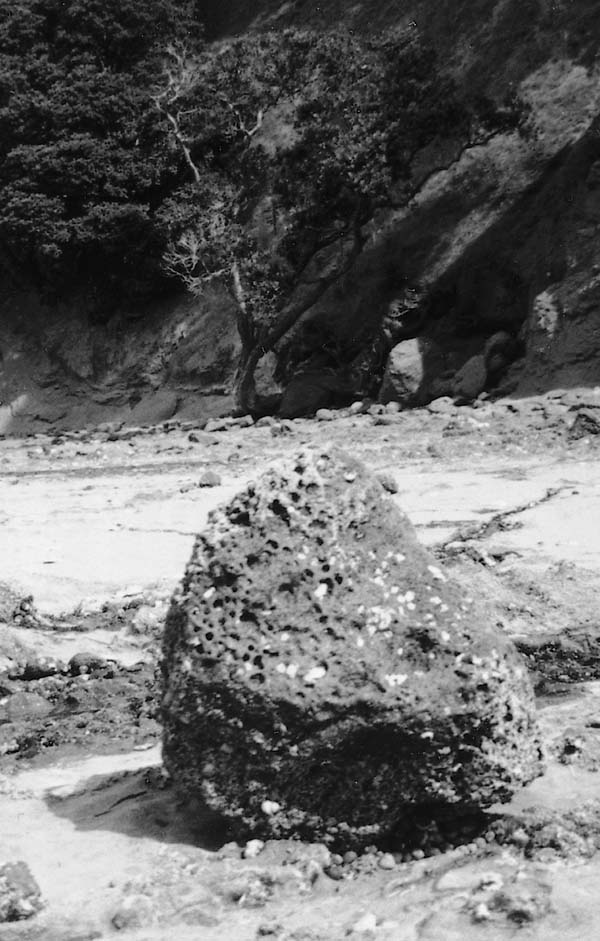
One of the many large basalt bounders released from the cliffs between Ōpahi and Mita bays. photographer Shirley Whittlestone
The volcanic fingerprint
In many places layering is absent from the sandstone. Here the rocks are dark grey in colour and gritty in texture, due to a high content of volcanic ash. These rocks are known as the Parnell grits. The disorderly occurrence of these grits suggests an origin in lahars (mudflows), rolling down the flanks of volcanoes into the sea. The largest exposure of the grits I have observed is in the cliffs between Dairy and Big Bays, where stratification is absent.
In both the layered sandstone and the grits, volcanic stones are also present, either at random, or in layers. These basalts are easily recognisable by their dark colour and by inclusions of black crystals and bubbles. (Gas is liberated when pressure is released from molten lava). While sandstone fragments soon grind to sand, the basalt fragments are much more resistant, surviving as rounded pebbles and becoming disproportionately abundant. Some stones are much larger, becoming rounded boulders.
The broad and level platform between Ōpahi and Mita bays is a good place to study the volcanic aspect of the sandstones. Both the normal layered stone and large areas of Parnell grits can be seen in the cliff face. There is a profusion of basalt pebbles near the high-tide mark. There are also some large basalt boulders standing in isolation on the platform. These have been released from the cliffs by erosion of the sandstone and have rolled down on to the platform. Resistant to weathering, and too heavy to be rolled by the limited wave action inside the harbour, they sit stranded for far into the future. The largest stone, well out on the platform, is about 60 centimetres in diameter and must weigh about half a tonne. These boulders must have arrived by aerial trajectory from volcanoes many kilometres away. They remain an impressive monument to the explosive power that launched them. Some basalt stones can be seen still embedded in the sandstone of the platform. The Māori had a better story, which I believe relates to this very spot. (Ōpahi was the principal settlement on the harbour from early times). Percy Smith tells it thus:
The old maioros or ramparts of the Ngāti Rongo pā at Mahurangi Heads can still be seen, while at the bottom of the cliffs a number of large smooth stones still lie where the Ngāti Rongo defenders had rolled them onto the attacking Ngā Puhi.
Richard Hodgskin, on the Buffalo in 1834, although ‘not much of a geologist’, knew better, noting:
I have often picked up pieces of lava, which would seem to indicate the existence of volcanic action…
Such large basalt boulders can be found all around the Mahurangi shoreline. The most striking evidence of volcanism at Mahurangi is the corner headland between Big Bay and Kawau Bay. Curiously lacking a name on any map or chart, it was known as Bush Point, according to Lindsay Kirby of Rodmersham. Its imposing bluff is made of volcanic breccia, here a composite of sharp basalt fragments and some red scoria, cemented with ash. Their similarity to the ‘plum pudding’ rocks of the Waitakere Ranges, suggest a common origin in the western volcanoes. The shoreline of Bush Point offers one the most interesting shore walks of the area. It is piled high with debris fallen from the volcanic deposit. As well as boulders of breccia, there are many stones of homogeneous basalt, the largest and most abundant in Mahurangi (the largest measures about two metres by one metre). Boulders of a lighter coloured basalt, smooth grained and bubble free, are present in lesser numbers, as well as a few of breccia with a white matrix. All this means that Bush Point is not the site of an old volcano, or even a volcanic intrusion, squeezed up a crack. It is the result of a pyroclastic flow from some remote volcano, a fiery cloud produced by the collapsing aerial column of an eruption. The red-hot solids, ranging from boulders to small stones and ash, are fluidised by searingly hot gases, and may flow for long distances overland, and over or even under the sea. The fragments go on emitting gases as they flow, prolonging the fluidisation. This deposit sits on a base of horizontally-bedded sandstone, exposed at the shore, confirming that the material has been transported laterally from elsewhere. It is difficult to tell its depth because of the toe slopes of debris, but my guess is at least 50 metres. There is a second smaller, but still massive, deposit of the same material in the cliffs a little to the north. I believe these large deposits have been dumped on the sea surface by two great massive fiery clouds, the debris settling to the floor of the basin and becoming cemented together in time.
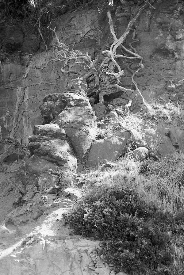
The most striking evidence of volcanism in the Mahurangi is this pyroclastic flow at Bush Point. photographer Shirley Whittlestone
Thinner deposits of this type can be seen in the cliffs at the south end of Waiwera beach, where a band of uniform thickness (about a metre) is exposed on the platform and runs obliquely up the cliff, following the bedding planes. Another of similar dimensions can be seen on the north side on the Puhoi mouth. Thin veins of breccia exist in the shore platforms along both sides of the harbour, and are the source of the hard black basalt pebbles which strew the shoreline.
I once found the cross-section of a charred stick embedded in the sandstone in Huawai Bay, a reminder that plant life went on in the midst of this volcanic activity, and was sometimes extinguished by it. Walnut-sized coconut fossils have been found in the Waitematā series.
While the Waitematā basin was filling with sediments, marine life flourished within it. Intact fossil shells are rare in these sandstones, although fragments are not uncommon. Microfossils (foraminifera) are present, and these have served to date the formation at about 25–17 million years old. The Parnell grits contain more fossil fragments. The lahars that formed them, swept up shells while crossing the beaches and ground them in passage. A grey gritty stone that I picked up between Sullivans and Mita bays has many small fragments of shell, and a few small intact ones. Examination with a hand glass shows that the calcareous material is largely made up of pieces of small corals, of assorted kinds, easily recognisable by the regular perforations where polyps once emerged. Although it may seem novel to associate Mahurangi with a coral sea, this is not an unusual find. At Cape Rodney, thirty different species of coral have been identified. These fossils (and the coconuts) indicate warm water within the filling basin, but their small size indicates that the water was only just warm enough for coral.
The glaciation and the thaw
Global temperatures change continually in a cyclic manner. The last phase of the Mahurangi’s story, the making of a tideway, is not a matter of the making or sculpting of rocks, but has to do with the coming and the passing of the last glaciation. This last throw of the geological dice sent no glaciers rolling down these valleys, but the events left their mark just as surely, through the fluctuation of sea levels. The modern era of geology is the Ice Age. It is not the first such frigid event; in fact it was the traces of ice ages 350 to 230 million years ago that provided much of the early evidence for continental drift. The modern Ice Age dates from 1.9 million years ago, when there was a major advance of the ice sheets. Since then, there have been three other major glaciations (and lesser ones), interspersed with warmer interglacial periods. We still live in the Ice Age, but are enjoying a particularly mild interglacial period, which we are doing our best to prolong with greenhouse gas emissions.
The last glaciation was a particularly severe one, reaching a maximum about 15 000 years ago. At that time about a third of the earth’s surface was covered with ice, compared with a tenth today. The earth was about eight degrees Celsius cooler than now. An extra 50 million cubic kilometres of water locked up as ice, dropped sea level to 130 metres lower than today.
Northern Aotearoa escaped the cold breath of the glaciers, which advanced in the South Island, changing the flora in an alpine direction. The warm temperate forests of kauri and podocarps were able to survive, and in fact extended out on to the exposed continental shelves. Three distinct layers of kauri forest can be distinguished in the sands of the Aupouri Peninsula; the lowest apparently died by drowning.
The coastline of eastern Northland stood outside the Coromandel Peninsula and Great Barrier, and north of the Mokohinau Islands. The Hauraki Gulf would then have been a great swamp, an extension of the Hauraki Plains, with the familiar vegetation. The floor of the gulf is underlain by the same volcanic sands that underlie the Hauraki Plains. These date to the beginning of the Ice Age, when the Waikato River followed this course to the sea. The Waitematā and Mahurangi Rivers would have joined it on the plain.
The crest of the Mahurangi hills was higher above sea-level than now and the normal processes of catchment sculpture would have gone on apace in the soft stone. The Mahurangi, Pukapuka and Te Kapa streams would have flowed through V-shaped valleys, in their upper reaches and through alluvial flats where the harbour is now.
It was the big thaw, beginning in Aotearoa about 13 000 years ago, that created the harbour we know. As the icecaps retreated, the resurgent sea crept into the gulf, and less than 10 000 years ago began to invade the Mahurangi. By this time the hills were in their present form and forested, and erosion would have been slow. But the cutting of cliffs along the new tideway began with vigour. The drowned valleys, filled in by the debris and by stream-borne silt, became shallow estuaries.
Cliff-cutting is rapid in this sandstone, especially on exposed shores, such as the east face of Saddle Island, which will be severed within a few centuries. A whole pa has disappeared from its northern end. Mahurangi Island off Waiwera, a major pa in the 1700s, has its summit much-reduced. The Auckland City Council, which must cope with the problems of cliff retreat around the Eastern Bays, estimates the rate at two metres a century. A more modern indication is the remnant of the Mahurangi West Road where it ended on the shore at Opaheke Point. It was built about 1880. My cousin remembered camping on it fifty years ago, when it was a carriage width. It is now just discernible. Below the headland separating the Puhoi and Te Muri, I found a weathered pōhutukawa trunk. Two of its branch stubs sat in deep potholes, worn as the log rocked in the waves. The rock is clearly softer than the wood. By the poles in Jamieson Bay, I noticed recently on the bedrock a few spots of antifouling paint, I think not more than two seasons old, but standing about a millimetre proud. This suggests the surface may fret away at about half a millimetre a year.
There is evidence from elevated marine terraces that there have been times warmer than now during the Ice Age, and consequent higher sea levels. On the Kaipara, terraces have been noted at various levels up to 170 metres above present sea level, and on the North Shore at similar levels, particularly at 70m and below (Takapuna to Silverdale). I believe I can discern such terraces in Te Muri, high on slopes facing seaward, and at a lower level in Dyers Creek, where it narrows. Elevated marine terraces could equally well be explained by the land itself rising. While there is no consensus on this issue, it is generally believed that Northland is indeed slowly rising.
There is clear evidence that sea-level has been higher in this interglacial period. A warmer time, 4000 years ago, left well defined terraces at 2 metres above present sea-level. This provided the flat land of Auckland’s Eastern Bays. It also formed the beach flats of Wenderholm and Te Muri, and those in the harbour’s bays. There have also been other times when the sea-level stood lower than today. In the previous interglacial period it reached a maximum 15 metres lower. It is likely that older cliffs and platforms lie buried in the mud beneath the present wave platforms.
There have been dire warnings of rises in sea level of a metre or more in the next 50 years, due to the anthropogenic global warming. Such a rise would come mainly from expansion of existing sea water, and to a limited degree from melting of polar ice. We should heed such warnings, but at the same time realise the uncertainty of such predictions, based on too short a span of records. These are complicated by climatic cycles due to such factors as variations in sunspot activity, which produce changes in temperature far outweighing those now being looked for. A recent analysis by the Department of Scientific and Industrial Research tide records back to the beginning of this century, shows a steady rise in sea-level of 1.2 millimetres per year, but no acceleration.
Conclusion
To readers who expected this history to start decently with the arrival of white settlers, I apologise, if this excursion back into geological time has proved tedious or baffling. With this in mind, I did try out these insights on an elderly relative, harbour resident, hoping to excite him with fascinating new insights into his surroundings. His response:
A load of bullshit!—how can they know?
Argument on the compelling weight of evidence was of no avail. Scepticism must be respected by a scientist as healthy, although preferably in less strident form. Geology is, after all, a vast accumulation of observations, interpreted as hard and not-so-hard ‘facts’, woven together with inspired speculation into a presentable fabric. As time goes by, the gap-filling guesses are replaced by fact. This last process has become rapid in geology.
I suggest you do not take this imperfect amateur account as gospel, but take a harder look yourself at the stones you have stumbled over for years on the shore. You will soon agree that there is something in it. It may even add a new dimension to your appreciation of the place. I picked up casually near Mita Bay, a stone which proved to be a conglomerate containing chips of sandstone, black basalt, red scoria, pieces of shell and a multitude of coral fragments, all cemented together with hardened silt. This one stone is no less than a potted history of the substance of Mahurangi. Such evidence is everywhere underfoot. To the seeing eye, the story is also writ large in the cliffs, in their ordered layering or wild contortions.
It is a pity to live in the Mahurangi and never learn to read its landscapes and its rocks, for beside this history in stone, human occupation is but the blink of an eye.
Footnote: Rates of sea-level rise When Dr Ronald Locker completed Jade River : A History of the Mahurangi in 1994, he was unaware that the sea level, between 1993 and 2003 would rise an average of ~3.1 millimetres per year and that the ‘recent’ analysis, showing no acceleration, had already been dramatically overtaken by events.
Footnote: Sunspot activity vs. greenhouse gas emissions While Dr Ronald Locker could be excused for not being aware, by 1994, of accelerating sea-level rise, his assertion that variations in sunspot activity far outweighed the effect of greenhouse gas emissions was entirely at odds with the findings of climate scientists at the time. The Intergovernmental Panel on Climate Change report of 1990 specifically rejected the contention that the main cause of observed warming was solar variation.