
Ten minutes and local board agrees to walk

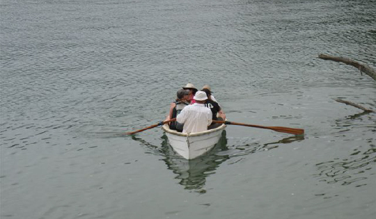
One of Many: Ferrymen Jefferson Chapple and Andrew Hay plied the 600-metre crossing of the Pūhoi Estuary multiple times, adding utter authenticity to the Mahurangi Coastal Trail supporters walk. image Evelyn Brown
A coastal trail, for the most part, should be built close to the water.
But not only is it necessary to skirt the steep and cliff sections of the coast, the elevation gained rewards walkers with views that more than compensate for the slight exertion involved. The first jaw-dropping vantage on the proposed Mahurangi Coastal Trail route is reached after a 300-metre level section lying close along the northern bank of the Pūhoi River. From a rise of only 12 metres, the view of Wenderholm spit, lapped by a spring tide, surely sold Sunday’s walkers on the concept there and then.
Rather than adhere to the current farm track, which briefly becomes uncharacteristically steep, the coastal trail will likely switch back to pick out a more leisurely route before rejoining the path where its gradient is gentler. This point provides an even more commanding vista of Wenderholm, and on Sunday given the absence of the less strenuous alternative, an excuse to allow breathing and heart rates to return to normal.
The balance of the stroll to Te Muri saddle usually provides further fine vistas of Wenderholm, but by that stage of the walk on Sunday, a heavier shower of rain was limiting visibility. It cleared in time for the reveal the hide-away that is Te Muri, with none camped there, in contrast to the previous two long weekends when the backpackers campground was well patronised. It is the solitude of Te Muri, relative to Wenderholm and Sullivans Bay, that its adherents particularly value. And even when its little campground is ‘full’, Te Muri retains a sense of isolation thanks to the total absence of cars.
Te Muri is the gem that cries out to be a waypoint in Te Araroa, the national walkway. The current farm road, rather than be upgraded for vehicular park access, is a ready-made scenic ridge trail of national importance. Currently Te Araroa is a mirage south of Pūhoi, except for those who kayak the river to Wenderholm. South of the Waiwera River the national walkway amounts to clambering around the rocks, which as glorious a pastime as that can be, is unforgivably tide and swell dependent.
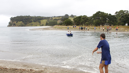
No Place for Boardwalk: While it was the expedient point at which to ferry supporters across Te Muri on Sunday, the boardwalk and bridge needed to provide all‑tide access would be located 400 metres or more upstream, where it would be screened by mangroves and not detract from the almost visually pristine estuary—note the white sign warning of overhead wires. image Majorlook Productions
The nascent northern spit of the estuary, being perfectly sheltered from the freshening northeasterly, was the obvious place for walkers to eat their lunches. A 10-minute gentle climb had walkers reach the second saddle, overlooking Sullivans Bay, and their bus back to Waiwera. But not before receiving a rousing invitation by Bronwen Turner to join Friends of Regional Parks and support that group’s determination to see the regional parks network survive the transition in the region’s governance structures. Bronwen’s father, Judge Arnold Turner, walkers will be interested to know, played a pivotal role in ensuring that the locals’ determination to keep Te Muri car free 25 years ago prevailed over plans to drive a road and road bridge across the estuary to a 4000-car car park.
With the 2011 purchase of 400 hectares of additional parkland at Te Muri for $15 million, there is now a very real danger that the area’s isolation and tranquillity will be diminished by the imperative to justify the purchase by opening up the park to vehicular access. Hence the need to encourage the park’s policy makers adopt a broader perspective and to visualise a Mahurangi Coastal Trail of regional, if not national, importance connecting magnificently with Te Araroa, the national walkway.
Sunday’s walk was timed to energise a deputation to the Rodney Local Board scheduled the following afternoon. By the end of that walk, involving 42 walkers, ferrymen and a busman, it was obvious as to what the deputation should ask of its board members, during its 10-minute presentation: Invite the board to do the walk. If, subsequently, any board member is disinclined to support a detailed study being made of the concept, then no amount of pleading in the old Rodney District Council chambers is likely change such heart of stone.
An eloquent invitation was issued by Andrea Boyed, great-granddaughter of Ngārewa Sullivan—hence Ngārewa Drive, hence Sullivans Bay—assisted by board member June Turner’s enthusiastic account of Sunday’s walk.
Small wonder the board agreed to walk the walk, just as soon as a suitable day and tide could be decided upon.