
First draft of report for coastal trail discussion at club

Draft report for Mahurangi Club discussion
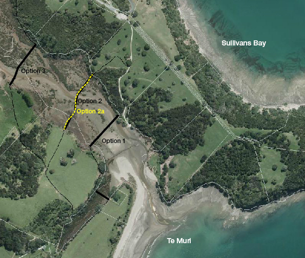
Crossing Options: While the cheapest option is at the point that the present farm road meets the estuary, for a few more thousands, a Te Muri crossing further upstream would detract less from the inlets pristine feel. Conceptual Te Muri options Roger Williams and the Mahurangi Magazine
Te Muri is the centre of four regional park identities: Mahurangi East, Mahurangi West, Te Muri and Wenderholm.
Mahurangi Regional Park was extended by a $15 million purchase of 383as published: 407 hectares of adjacent farmland during the latter part of the Auckland Regional Council era.
Te Muri is unique in that it provides a pristine beach free of development. It has a charm that approaches the much-vaunted New Chums Beach in the Coromandel, yet is less than 40 kilometres from downtown Auckland.
The question is how to provide better public access to this gem of the Auckland Council regional parks portfolio, in a way that enhances its charm and its unique location.
The principal options include:
- Do nothing
- Link the parks together with tracks bridges and ferries
- Provide a separate road access with on-site parking
Do nothing
The current access to Te Muri is from the car park above Sullivans Bay within the Mahurangi Regional Park. The access from the car park to the bay is down a metalled farm track to Te Muri Stream. The stream can be crossed by wading at half tide or lower. The flow can be moderately strong and hazardous to cross on an outgoing tide.
There is no defined access from the south. At Wenderholm there is a boat ramp and a wharf, but no similar access point to the north.
Hungry Creek Road accesses the farm from inland but is a private road and currently unsuitable for park access.
Links within the parks
This would involve a bridged crossing of Te Muri Stream for pedestrians and cycles to the north and a track to a wharf structure for a ferry or water taxi. This could be later upgraded to a footbridge. It is envisaged that a wharf structure at Mahurangi West would provide water taxi access to Scotts Landing and Mahurangi West Park as well as Motuora Island. Details of linking options are given later in this document.
Provide separate access with on-site parking
This would involve a major upgrade of Hungry Creek Road. Car parking for 1000–2000 cars has been suggested.
Te Araroa, the national walkway
The current proposed route for this walkway from Pūhoi to Wenderholm is along the south bank or the river but is currently unavailable due to landowner issues. The alternative is to use Hungry Creek Road provided that it does not become an access route to the park. This route would require a crossing of the Pūhoi River by ferry or bridge as in the Links within the Parks above.
Sea kayak trail
The park, the remote camping experience available at Te Muri are totally compatible with the proposed sea kayak trail.
Linking elements
- Wharf structure on north side of Pūhoi River. (35-metre long, founded on rock). Medium-term additional wharf structure on south side Long term option an upstream footbridge as per CME proposal. 70-metre boardwalk, 50-metre bridge – 5-span, 100-metre boardwalk, 30-metre bridge-3span, 50-metre boardwalk.
- Improved farm track to saddle 335 metre. (1 in 8 average clay track will require metal. May require local grading to achieve 1 in 8)
- Benched track in farm paddock 450 metre (about 1 in 10, initially grassed but may require metal dressing)
- Track in farm paddock behind beach top. Level on sandy base. It is envisaged that this would within a planted pōhutukawa buffer zone from the beach and offer an alternative route to walking along the beach.
- Existing track within bush near beach house accommodation. An existing bridge needs strengthening or rebuilding.
- Crossing of inlet either above or below cemetery. 50-metre boardwalk
- Paddock crossing. 300 metre. Mown track only
- Paddock perimeter track. Some grading and 1–3-metre bridge. Maintenance by mowing.
Te Muri Stream Crossing Option 1 – estimate $130 000
- Direct crossing of Te Muri Stream to pōhutukawa tree. 100-metre boardwalk and 25 metre 2-span bridge
Te Muri Stream Crossing Option 2 – $167 000 including access track
- Middle crossing of Te Muri Stream via small island then to existing paddock access. 60-metre boardwalk, island, 25-metre boardwalk, 30-metre 3-span bridge, 75-metre boardwalk.
- Paddock crossing. 150-metre Some re contouring to achieve 1 in 8. Metalling required. It is envisaged that this paddock could be revegetated in native plants.
Te Muri Stream Crossing Option 3 – $259 000 including access track
- Upper Crossing of Te Muri Stream 30-metre boardwalk, 30-metre 3-span bridge, 110-metre of boardwalk to bush.
- Bush track around base of hill to northwest 300-metre, maybe one third of which needs boardwalk.
325m of metalled track at 1 in 8 to Ngārewa Drive - Existing track to Car park. Existing track approx 1 in 8. No work required
- Ngārewa drive car park extension
Comment on Te Muri Stream crossing options
- Direct crossing is the lowest cost option but is visible from existing crossing point detracting from the wading experience.
- Middle crossing retains the visual separation but is more expensive.
- As for Option 2, but even less aesthetically obtrusive, due to gently curving route.
- Upper crossing is significantly more expensive.
Staging
Once the overall option and Te Muri crossing options are decided, priority should be given to the Te Muri Crossing and a landing structure on the north bank of the Pūhoi River.
Standards
As per SNZ HB 8630:2004 Tracks and Outdoor Visitor Structures
User Group Short Stop Travellers. User Group 1.
Modified as follows. Tracks 2.0-metre wide to allow cycling and access for mowing. Boardwalk structures 1.6-metre wide, no handrails. Bridge structures 1.2-metre wide, handrails both sides.
Costings
Parameter costing for this assessment includes 50% addition for GST and allowance for fees and contingences. Rates to be verified
Tracks $20–$60 per metre
Boardwalks $700 per metre
Bridges $2000 per metre
Use of volunteer labour can effectively halve the rates above—refer Tāwharanui Open Sanctuary Society.
Use of volunteer labour can allow the project to be completed much earlier than would otherwise be the case for a fully funded council project.