
Dr James Hansen unleashed on Auckland

Post-Ice-Sheet Mahurangi: Given unabated greenhouse gas emissions and the fact that Earth has only enjoyed conditions conducive to ice-sheet retention for a tiny fraction of its 4.54 billion years, the likelihood of an eventual 80-metres of sea-level rise is considerable. Only the timescale, at present, is unknowable. map Jonathan Musther
Schoolchildren will assume that the crowds he addressed filled stadiums.
In decades hence, when told Dr James Hansen lectured in Aotearoa in 2011, they will assume it was to Rugby World Cup-sized audiences.
Thermal inertia in Earth systems allows the mainstream media to treat anthropogenic global warming as a mere possibility, or as a debate—so far the atmosphere is less than 1° warmer, and the oceans about half that. But children raised with the harsh reality of warming will be incredulous that, in the 2010s, civic leaders were treating it as a mere consideration.
The discussion document unleashed on Auckland on Wednesday contains one instance of the phrase global warming, three of ‘sea level rise’ and 12 of ‘climate change’. None of those phrases, however, appear in the aspirational section, titled Auckland 2040: What We Can Look Like—the closest it comes is ‘environmentally friendly living’.
The sea level by 2040 won’t be enormously higher than it is today—about 85 millimetres, if a 10-year doubling period is assumed. But rather than its…
world status as a city of global scale [be] secure[] as a most liveable, prosperous, affordable and beautiful 21st century city
…Auckland will be scrambling for higher ground, and if the doubling period proves to be seven, or even five years, that scramble will be a desperately urgent one.
While five metres by 2100 is alarming, sea level rise will be oblivious of new-century niceties—the annual rate by then would be half a metre per year and accelerating. By about 2135, Antarctica and Greenland would be ice sheet –free and the Tāmaki isthmus indistinguishable from the balance of Hauraki Gulf waters. The main geographic feature would be Manukau Passage.

Life South of the Bombays: Long-term location of the metropolis is a 25-minute high-speed rail ride south, which would suggest rational beings would be planning for the bulk of future growth to occur there. map Jonathan Musther
There is no region in Aotearoa where the coastline will be more radically re-drawn. Certainly Christchurch and Invercargill both face a dramatic retreat inland. But there is no inland from the Tāmaki isthmus. Waitakere, Mahurangi, Tamahunga and Brynderwyn will become islands little larger than Great Barrier; the balance of Northland reduced to size of about one and a half Stewart Islands.
Mahurangi Harbour – Kaipara Flats becomes Mahurangi Straight. Along with Manukau Passage, this will be site of significant power generation as strong tides surge from coast to coast. About all that will remain of Mahurangi Harbour is a smallish island, Mahurangi West ?
South of the isthmus, Hunua would form a fine big island. Albeit the size of Hong Kong, it is hard to see it as Aotearoa’s economic powerhouse.
The first site capable of hosting the new metropolis is much farther south; south of Matamata, almost as far south as Tirau. Although the new Makaurau will also need to embody Hamilton and Tauranga, it shouldn’t be larger in geographic footprint than those two combined. This is readily achievable with mostly low-rise buildings of two to four stories—South Beach, Miami –style. Compact, human-scaled cities are green cities. Homo sapiens sapiens is a walking machine. Design the urban environment to reward walkers, and less of it needs to be hospital wards. In a green city designed for Auckland Unleashed’s 2.1 million by 2040, no job would be farther than half an hour away by bicycle. Better, it could be the world’s first 100% Shweeb city.
On Tuesday, the New Zealand Transport Agency stole much of the thunder of Auckland Unleashed by releasing its harbour crossing study the day before the Auckland plan was to be launched. The report is the undisguised reflection of the Minister of Transport’s determination to head off the Auckland mayor’s mandated rail plans.
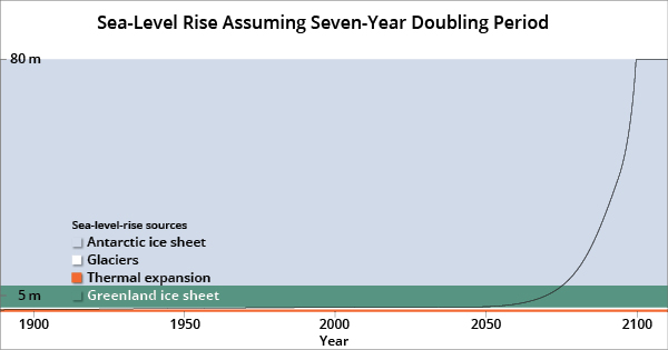
All Done By 2100: A seven-year doubling time of ice sheet contribution to sea level rise would see the maximum rise possible, play out by the end of this century. chart Mahurangi Magazine
Auckland’s opportunity for comprehensive urban rail was blown in the early 1950s, when the struggle to have rail included on the Auckland Harbour Bridge was finally lost. A rail‑only crossing, and a rail link to the airport six years later, would have resulted in much more energy-efficient metropolis.
Plans for rail to Albany have arrived too late; the future key infrastructure of the northern motu is broadband and ferries—ex Rodney mayor John Law’s visionary ‘connectivity by the sea’.
Auckland’s urgent need for rail is to its new location—a 25-minute high-speed journey south. From here on in, new and replacement building and infrastructure needs to be in the new location, capable of being moved to the new location, or be expendable. Meantime, bring on true broadband—bring the work to the (desk-bound) people, not the people to their work.
It is too early to know whether the doubling time of sea level rise proves to be ten, seven, or five years. If it is the latter, by 2040 tides could more than 0.6 metres higher than present, and regularly inundating the northern and western motorways.
Auckland unleashed, and rebuilt as the world’s most affordable, beautiful, liveable, resilient and sustainable 21st century city…
…above sea level.