
Their way and the highway bypass


Double Bypass: Warkworth received its first bypass in the 1940s, but failed to develop healthier town planning habits. map Mahurangi Magazine
It’s all on for the riverside town. The proposed town centre upgrade and now a proposed district plan change.
The council’s explanation is that the proposed plan change comes out of Warkworth’s structure plan and would ‘maintain the present boutique-flavour of the town’s central commercial zone’.
The reality is that Rodney District Council is attempting to head off the establishment of a bulk retail operation in Neville Street, following the purchase of sufficient land there for a supermarket by an entity said to be acting for New World and Pak’nSave umbrella company, Foodstuffs. This is the stable door that was shut only after the Warehouse horse had bolted into Snells Beach, and into a similarly flawed location.
The structure plan process, the council press release states, ‘went through an extensive public consultation process leading to its adoption in September 2004’.
What it omits to mention is that the State Highway One by-pass formed a major component of that consultation, only to be expunged from the final plan, without explanation.
Regardless of that remarkable deficiency, Warkworth lacks an agreed strategic plan—updated, of course, from being merely ‘sustainable’ to climate change-ready!
At the risk of stating the bleedin’ obvious, Warkworth’s unique strategic assets are:
- The Mahurangi River—leading to the first natural Hauraki Gulf harbour north of Auckland
- The Wilson Cement Works—nationally important industrial heritage site.
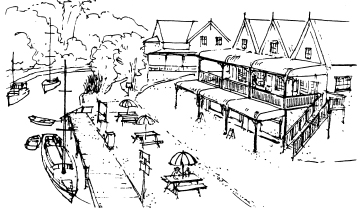
1988 to 2008: Suggestions for Mahurangi Riverbank, 1988, visualises ‘the day when the Warkworth waterfront is the vibrantface of the town—the old days, when it was the town’s backside, forgotten.’ artist Robin Pendred
The river with its indigenous forest backdrop has long been considered inviolate. But the parallel call for premises to address the river has never been matched by a strategy for achieving that goal.
A triple-pronged strategy might be adopted:
- A ‘new Wharf Street’
- A Wilson Cement Works ferry
- A town basin.
A ‘new Wharf Street’
Friends of the Mahurangi first formally presented its Wharf Street concept in 1988. Encouragingly, the council’s proposed town centre upgrade option A includes river-facing retail precinct.
The unrecognised opportunity, however, is for this to be just the beginning of a new extended Wharf Street running from Wilson Bridge to Lucy Moore Park—a street for people, rather than for cars and parking. A vibrant area, and safe to use morning, day and evening.
The current single file footpath between Wharf Street and the Wilson Bridge has proved insufficient to convince business owners to develop the connections between Queen Street and the river that are crying out to be made.
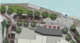
Option 1: This could be stage one of a new Wharf Street running the length of the town. warkworth concept plan Rodney District Council
A developer would presumably pick up the cost of converting the car park into retail premises and pedestrian precinct—but preferably without the vestigial one-way road and parking shown in that option.
What is decided for Wharf Street will signal whether the council comprehends that the town’s future is tied to its ability to gain critical mass for a river-facing retail precinct, in which the pedestrian rules. It does not need to exclude vehicles—service vehicles, mobility scooters, bicycles and electric cars, provided they proceeded at walking pace, could all be tolerated.
This pedestrian precinct, of course, would not exist in isolation. It would simply represent the central business section of an eventual Falls Road to Dawson Creek walkway—the Mahurangi Walkway.
Investment—much of which could be private—in the town section precinct, would be a much more constructive option than that part of the council’s concept that seeks, at the cost of considerable expense and disruption, to make Queen Street more pedestrian friendly. Hurstmere Road, Takapuna where bumper-to-bumper traffic is the norm, should be ample warning that narrowing the street will not dissuade through traffic. Only radical measures, such as prohibiting traffic from exiting Elizabeth Street to the north and east, would substantially reduce through traffic.
But more importantly, if it is agreed that the riverside precinct is of strategic importance to Warkworth, the resources available for walk and cycle friendly environments should be invested there, rather than have Queen Street and Wharf Street compete to offer the same experience—Warkworth can then offer the best of both car and car-less worlds.
A Wilson Cement Works walkway and ferry
The Wilson Cement Works is Warkworth’s greatest untapped asset.
Today it lies just out of site and mostly out of mind but when it was the town’s main employer, and the Mahurangi River was a busy place, it was a huge presence—albeit a mile downstream. The employees walked that mile to work along the riverbank, the freshwater pipe providing a useful footbridge across the several side streams.
One of the Mahurangi’s greatest sons, the late Dr John Andrew strongly backed a bid in the 1970s to interest the regional council in a coastal walkway from Wenderholm to Mahurangi West. In his letter of support, he described relaxed walking as ‘exercise par excellence’.
Given this health benefit, and given the climate action imperative to encourage a change in the car-centric mindset, the Wilson Cement Works provides the reward necessary for folk to undertake the one-mile walk, provided that vehicle access to the site was strictly limited to service vehicles.
But as important, a car-free access strategy automatically ensures the viability of a ferry service, which in turn is necessary to ensure universal access.
Socially important, it also means that the works are readily accessible to non car-owning families and individuals.
The economic importance of making the town the staging point to the Wilson Cement Works is that it ensures thirsty and hungry works visitors have every inducement to prolong their stay in the town.
Another, not inconsiderable bonus of the vehicle-free access model is that it would render the tortuous Wilson Road a fine indigenous forest walkway, albeit one shared with service and residents’ vehicles—infinitely preferable to attempting to upgrade the road to cope with visitor vehicles.
A town basin
The desire for Warkworth to be more accessible to, and accommodating of, visiting boats is unanimous. A number of concepts have been advanced:
- Dredging the Mahurangi River
- A lock and weir
- A half tide weir
- Channel marking.
The simple expedient of surveying and better-marking the existing channel would allow visiting boats to make the best of the navigability afforded. It would also ascertain what improvements to navigability could be achieved with varying degrees of dredging.
A lock and weir
A lock and weir constructed downstream of the Wilson Cement Works would transform Warkworth, from a recreational and commercial perspective. No serious study has been commissioned to determine if this could be achieved in an environmentally or economically acceptable manner. It is even conceivable that the system could be design to function as a sediment trap, reducing the ongoing burden of dredging.
Dredging of the Mahurangi River
Both large-scale dredging and lock and weir concepts would require extensive study and modelling of the Mahurangi River. Because the economic implications are enormous, and of regional significance, and because such studies would be expensive, these concepts are only likely to be explored as a regional project.
Meantime, there are other projects struggling for recognition and support:
- The town hall restoration
- The Mahurangi Walkway
- The Wilson Bridge redevelopment
Given the strenuous efforts now being made by the council to reduce the annual plan expenditure to a level less likely to spark a rate revolt, fixing things that are arguably not broken—much of the proposed town centre upgrade—will come under particularly close scrutiny.
The downturn in the economy and freshly rediscovered fiscal restraint provides the perfect excuse to revisit the proposal’s priorities.
Ask any person who lives in or travels through Warkworth daily what their greatest concern is, and there is a thundering consensus:
- The Hill Street intersection
- The Woodcocks Road intersection
And this is prior to the completion of the motorway to the Pūhoi Valley, which will generate more traffic and will deliver it to Warkworth in a more concentrated slug. Although rising fuel prices will have a sobering effect, growth in affluent northeastern Rodney District is likely to see traffic volumes continuing to build.
Readers will no doubt need no reminding of how long the issue of Hill Street has frustrated the community and its council. And while there is a plan agreed between the national roading authority and the council, it stubbornly ignores the community’s desire that the highway takes the obvious shortcut available to the west of the town.
But the cavalry may be coming: The Royal Commission on Auckland Governance has commissioned a study titled Transport Governance in Auckland.
If the study’s recommendations are implemented, a new regional body will be making such decisions—whether to pour good money after bad, in a vain attempt to ease Warkworth’s traffic woes, or invest in the obvious by-pass route to the west. And if the regional body had democratically elected representatives, as would seem likely, the community would involved in the decision making, and not stonewalled by an autonomous state entity.
The by-pass is of legitimate concern of Friends of the Mahurangi with its mandate for the care and reasonable use of the river and harbour.
Bridging the Mahurangi River, near the Wilson Cement Works, is periodically promoted as the solution to the Hill Street conundrum.
Aside from being inordinately expensive and leaving Warkworth saddled with the highway, the such a structure would have unacceptably negative scenic impact on a nationally important heritage site.
The rerouting of the highway is pivotal to the objective of the town becoming cohesive, and pedestrian and cycle -friendly.
Reroute the highway by removing the present dogleg—which, in the 1940s was itself a by-pass—and town no longer penalises those willing and able to move about, at least some of the time, without the use of cars. Bicycles, electric bicycles, mobility scooters, electric cars all start to get a fair shake.
This, in turn, would make a river walkway—built wide enough for two to walk and talk—all the way from Falls Road to the Wilson Cement Works. And why stop there!
A walk and cycle way the balance of the distance to Dawson Creek, behind Snells Beach, would add substantially to the physical, mental and economic health of the Mahurangi community.
The secret of a successful walk and cycle way is to provide an experience that is exclusive to those users, one unavailable to mere car users.
Wilson Bridge
The imperative to move the highway west of the town dictates that the redemption of Warkworth requires a top down strategy.
An example of this is the sadly under-utilised Wilson Bridge. That it still stands is a minor miracle, given the bridge builders’ creed—that once completed, your reward is you get to knock the old one down.
The principal reason it is under-used is that State Highway One impedes Elizabeth Street’s connection to the west of town. Another is that Elizabeth Street is inconveniently distant from the town centre in inclement weather.
The solution needn’t cost Warkworth ratepayers a penny:
- Banish the highway to just beyond the western limits of the town, and instantly walking and cycling to Hill Street and beyond becomes civilised.
- Grant a concession to an entrepreneur prepared to cover the bridge and keep it open for unimpeded foot traffic while, for example, serving coffee, smoothies or curries, depending on the time of day and clientele. Throw in the airspace above—an office, penthouse or kitchen—and the opportunity might be imminently marketable.
The town hall and the planned theatre
Warkworth was laid out 105 years ago, when the Mahurangi River ruled.
It interesting to reflect on how it might have been done differently, to avoid the river being increasingly marginalized following the abandonment of the steamer service to Auckland.
A simplistic option would for the town to have been laid out one sided, with the road running close beside the river. But the towns that are laid out that way—for example, Ngāruawāhia—have their own problems, including being less than compact.
The key to addressing the problem of the river being screened, by the buildings on the river side of Queen and Baxter streets, is to maintain or increase the connections between, and to create new ones.
These connections are also key to ensuring the vitality of the riverside precinct.
Also important is how well the buildings between river and road address the river. Most do not at all, a few do in a limited way. The redeveloped dairy factory is the solitary, and utterly exemplary, exception.
Unfortunately, the planned theatre scores poorly is this respect. Any proposal involving public land between road and river should meet a particularly high threshold. Sadly, the reverse is generally the norm, with community benefit, whether it be wastewater treatment plant or theatre, tending to outweigh environmental or aesthetic considerations.
Warkworth has a duty to restore its original ‘centre’, the town hall. By removing the rather poorly-executed art nouveau façade and restoring simple honesty the original entrance, the building would positively exude its heritage.
And by supplementing the cramped theatre facilities with a new connected building of complementary design, which incorporated a restaurant and café, the hall could again stage the likes of the memorable community productions that saw those paying for premium seats being feted with food and wine at dinning tables occupying the hall; the balance of the audience in the gallery—a format not possible in the planned Baxter Street structure, with its fixed, tiered seating.
The Old Masonic Hall
The Old Masonic Hall—mercifully preserved—is a classic example of how universally Warkworth once constructed its buildings with unseeing backsides to the river and the sun.
The unquestionable heritage significance of the hall precludes its relocation, spinning it 180 degrees or knocking holes in the back wall.
But it doesn’t mean that the dead space behind it cannot be redeemed to form an important part of the riverside precinct.
The 2005 meeting Friends of the Mahurangi organised as a Mahurangi River forum, at the behest of Stefan Seitzer when he was project manager of the Mahurangi Action Plan, inadvertently demonstrated the potential for this space.
Coffee, bacon and French toast cooked and consumed al fresco, the mist on the river, sparkling sun and conversation.
(The forum itself was unconstructive and somewhat unseemly. But this was due more to jealousies fueled by ill-considered inducements to the community by the regional council to establish a new catchment-based group, rather than the fact the gathering had forsaken the river favour of the indoors!)
Conclusion
It is not too late for Warkworth to find its bearings.
For too long, Hill Street and the community’s frustration with it, has been seen by the council and Transit as solely a transport issue. Reassurances that the delays and danger at Hill Street is within acceptable limits are lazy and disrespectful of the community view that this is not how the town should function—that it is deeply unsatisfactory and an absurdity.
It is timely that the unhelpful dogleg that State Highway One takes through the town is addressed. The community could do well to take a leaf out of the pioneering farmers’ book, and sort out a satisfactory route for themselves.
Folk desperate for the roads needed to link their farms to market organised themselves as roads boards. Those whose properties lay on the routes agreed, gifted the requisite strips of land. And although the boards received funding for the road building, the farmers often themselves laboured in the shafts of the horse scoops that carved out those roadways—curves that are often little changed unchanged today.
To own a property anywhere along the possible new routes for the by-pass is to be in a state of limbo. The alternative—while more-cohesive regional transport governance is awaited—is for a community-led initiative, with strong representation of the property holders affected, to get on with determining a useful route. While some professional help from the relevant councils and agencies would be useful, it is not rocket science—at least the members of the old roads boards didn’t appear overly overawed.
Comment for the submissions
Regarding the town centre upgrade, the council’s website states that all feedback must be received by Friday, 6 June 2008. However the consultation is informal and project leader Genevieve McGirr has told Friends of the Mahurangi that it may complete its submissions over this weekend.
The proposed district plan change, on the other hand, is a statutory process. Submissions on the proposed changes are will only be accepted up to 4.00 p.m. on Wednesday 18 June.
Members of Friends of the Mahurangi, and readers of the Mahurangi Magazine generally, are urged to comment. This can be done directly to the council or as a contribution to Friends of the Mahurangi submissions.
Comment is particularly sought of the ‘new Wharf Street’, as this concept is somewhat novel and has not been widely canvassed.