Hungry-Creek-Road-first policy right for the wrong reasons
author Cimino
published 30 September 2022
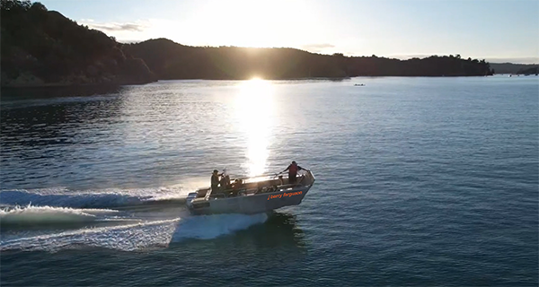
Members Only: Until such time as Mahurangi Action Incorporated seeks and obtains certification as a maritime transport operator, only its members will be invited aboard the J Barry Ferguson, to trial the Mahurangi Coastal Path. The former Auckland Council regional parks barge underway to Lagoon Bay, sporting her name new name—here, digitally enhanced—for the first time.
drone image Marek Planka
Prioritising private-light-vehicle access via Hungry Creek Road, ahead of a footbridge across
Te Muri estuary, is
counterproductivepossibly more productive adjective than the ‘perverse’ used in the first draft, and my ‘pertinacious’ second stab… policy making, fundamentally incompatible with Auckland Council’s own declared climate emergency.
Fortunately, the tens of millions that would be required to upgrade Hungry Creek Road to take the two-way bus and private light vehicle traffic cited, and the horse floats and camper vans implied—as well as walkers, cyclists, and horse riders—is vanishing unlikely to be budgeted during the 10-year life of the just-finalised regional parks management plan.
Long before there is any danger of Hungry Creek Road becoming the scene of such wanton climate exacerbation—not to mention squandered national-walkway opportunity—tens of thousands of regional park lovers will have demonstrated that walking access works. On 12 November, 55 members of Mahurangi Action will mount the first such trial. Termed by its organiser the “Pūhoi Wenzlick cousins family reunion”, many attending spent memorable summers camped at Te Muri Beach, prior to it becoming regional parkland, in 1973.
Key to facilitating the one-day gathering is Mahurangi Action’s May 2022 purchase of Auckland Council’s surplus-to-operations aluminium landing barge, formerly based at Sullivans Bay. The vessel had been commissioned to provide staff and service providers access to Mahurangi Peninsula parkland, before the legal road access that came with the 2019 acquisition of an additional 92 hectares there. Although Mahurangi Action has restored the craft’s marine certification as a workboat, the organisation has much more work to do before becoming a certificated maritime transport operator. Until that is achieved, however, Mahurangi Action members will trial the Mahurangi Coastal Path, ferrying across the estuary from the Wenderholm Jetty, and in some instances, also ferrying across the Mahurangi Harbour from Sullivans Bay to the outer peninsula.
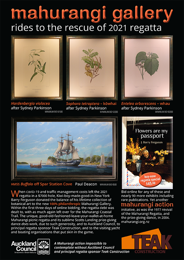
One Member’s Legacy: Constant friend of the Mahurangi Coastal Path, J Barry Ferguson, after bailing out the 2021 Mahurangi Regatta when covid-19 exacerbated costs blew the budget, backed the establishment of a fund that played a significant role in the purchase of the J Barry Ferguson, without which plans to advance the coastal trail would be currently caught in stays.
publication Mahurangi Cruising Club Yearbook
Aside from the fundamentally flawed two-waying Hungry Creek Road prerequisite, the new regional parks management plan has embraced the Mahurangi Coastal Path to a degree not seen in 35 years of management-plan participation, since the community first urged its creation:
A number of submitters advocated for the concept of a network of trails linking the regional parks – either by land (as, for example, the Te Araroa Trail) or by land and sea linkage (as, for example, the Mahurangi Coastal Path). The [regional parks management plan] acknowledges the merit of this concept but the Panel notes that the infrastructure required may need to be shared public/private. The Panel recommends further exploration of the concept in co-ordination with the advocate groups.
In respect to Hungry Creek Road access, it is impossible to overstate the imperative to thoroughly explore the opportunity for Pūhoi – Te Muri Beach to become one of the most sublime sections of Te Araroa, the national walkway. Currently, Te Araroa walkers leaving Pūhoi are denied the opportunity to emerge from a gruelling two-or-three-day slog, onto a sublime beach, its sense of splendid isolation, mercifully undiminished by the elsewhere all-pervading private-light-vehicle presence. The inland route, which begins at the southern end of Pākiri Beach with a gut-busting climb up the unrelenting north face of Pākiri Hill, provides scant succour to the traveller between there and Pūhoi. After Pūhoi, the majority are obliged to walk the inhospitable, and frequently hazardous, road shoulder to Wenderholm or Waiwera. If any souls deserved to have their access to Te Muri prioritised, it is the intrepid Te Araroa through-walkers, with the better part of 2500 remaining kilometres ahead of them.
The wrongestan archaic form much in need of revival in this age of proud wrongheadedness reason for insisting on Hungry Creek Road access ahead of Te Muri Crossing, however, is that walking from the “principal” arrival centre proposed near the western boundary of the park, and back, is the stuff of an all-day visit. For many family groups, and those for which a seven-kilometre return walk is problematic, accessing Te Muri Beach via Hungry Creek Road would be impracticable. Instead, private-light-vehicle traffic along Mahurangi West Road and Ngārewa Drive park would continue to intensify.
Admirably, the new management plan recognises, for the first time since the 1980s, that much better public transport access is required to the regional parks of Tāmaki Makaurau. Wenderholm is specifically mentioned:
21. Advocate for public transport services to be provided to [Wenderholm Regional Park].
The big regional-parks picture is that, since their 1960s inception, they have been profoundly private-light-vehicle-centric. While it will take time and a not inconsiderable amount of money to redress this situation, the most inappropriate development now would be to spend tens of millions to add a rare and beautiful private-light-vehicle-free park to the list of 27 already car-centric. The joint Mahurangi Action – Mahurangi Coastal Path Trust – Mahurangi Magazine submission, in addition to the Mahurangi Coastal Path, also advocated for a Wenderholm–Te Muri–Pūhoi loop trail:
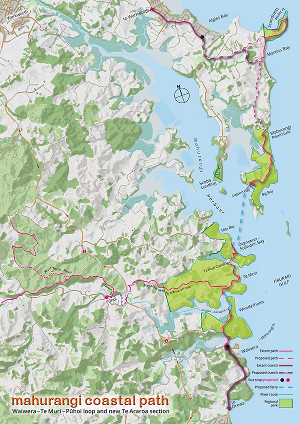
Linking Greater Mahurangi Regional Park: The downside of separating contiguous regional parkland into separate, operationally-centric regional-park units is the difficulty for policy makers and submitters of addressing the bigger pictures. Fortunately, thanks to the hearings panel recommendation that the concept of a network of trails linking the regional parks be further explored, in co-ordination with the advocate groups, this exploration, supplemental to the regional parks management plan process, can at last begin.
map Mahurangi Magazine | basemap Land Information New Zealand
Whether walked west to east as a Te Araroa through-walker, east to west as a Te Araroa first-timer, or purely for its standout standalone attractions, the proposed 17-kilometre Wenderholm–Te Muri–Pūhoi loop trail would be the diamond necklace to the jewel-in-the-regional-parks-crown that is Te Muri.
As grand as the loop trail concept is—one leg being the Pūhoi River—17-kilometres would be too daunting for many, even if a riverboat took the sting out of the return trip. This is just one of the reasons the joint submission advocated for fourth-tier transit solutions:
Fourth-tier targeted services are the lowest, typically slowest, component of [a] rapid transit network, the first tier of which consists of rail and bus ways. The second tier comprises high-frequency bus services, utilising bus lanes and traffic signal pre-emption. The third tier comprises connector and local bus and ferry services. The key word and concept is network. Without the lowly fourth tier providing crucial connectivity, the vicious cycle of private-light-vehicle dependency cannot be broken, with profound consequences for both equity of access and climate. A family, for example, cannot currently contemplate spending a day at a regional park beach [relying on public transport], without it being a crushingly near-insurmountable logistical challenge.
The key, the submission urged, is not to see fourth-tier as a solely regional park service, but one that also services adjacent communities—many younger and older non-urban residents suffer access-poverty, or are otherwise avoidably forced to contribute to greenhouse-gas emissions.
Had Mahurangi Action and the Mahurangi Coastal Path Trust continued to pin all hope for the first phase on the planned Te Muri Crossing, the new management plan would have been a devastating setback. Fortunately, pushback from some members of the Mahurangi West community, typically citing traffic generation, gave the two coastal-path organisations reason to revert to their original, strongly preferred plan for developing the path from the south—from Waiwera and Wenderholm. Ironically, it was the then-new regional parks management plan policy to prioritise a Te Muri Crossing that led to the organisations focussing on that crossing, and the subsequent community pushback.
All its eggs, fortunately for the Mahurangi Coastal Path, were not in the one, Te Muri Crossing basket. One trustee in particular had been strenuously arguing that, to be a Mahurangi Coastal Path, there must a Mahurangi Harbour ferry crossing. Thus, when it was learned that the aforementioned landing barge had become surplus to operations in 2019, its purchase was pursued doggedly. Having been purchased, the community pushback that ensued provided strong justification for pivoting away from Te Muri Crossing as the first connection—back to the Pūhoi Estuary. The barge, since renamed from Park Ranger to J Barry Ferguson—in honour of its principal funder and longtime coastal path supporter—with its opening bow ramp, is well suited to ferrying folk from the Wenderholm Jetty, across the Pūhoi Estuary, to trial the Mahurangi Coastal Path.
Members Only: Until such time as Mahurangi Action Incorporated seeks and obtains certification as a maritime transport operator, only its members will be invited aboard the J Barry Ferguson, to trial the Mahurangi Coastal Path. Others are free to cross by the Pūhoi Estuary by their own means, including wading knee-deep at dead low tide.
form Mahurangi Action
Although it is constructive to focus on what the management plan got right, it is obligatory to call out the wrong reasonsof this article’s title, in this year of unprecedented appreciation of the clear and present anthropogenic-global-heating component of increasingly extreme, extreme weather events. Top of the list is the policy advocating, effectively, for tens of millions to be spent destroying Hungry Creek Road road’s future as the sublime, closest non-urban section of Te Araroa to the metropolis of Aotearoa. Te Araroa, surely, is a far more splendid, patriotically indigenous rite of passage than a United Kingdom oe and GallipoliDescendants of the equal number of Turks who died, successfully defending their country from Allied invaders, it might be thought, could be considerably more deserving of commemorating 259 terrible days of courage and carnage. A marvellous uncle of the author by marriage survived losing an arm there, to become an unwavering proponent for no more wars, to his 100th year..
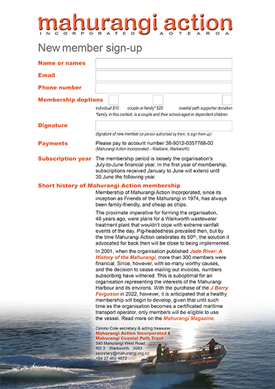
The singular, wrongestagain, the archaic form that is much in need of revival in this age of triumphant wrongheadedness policy is for the proposed arrival area near the terminus of Hungry Creek Road to be the “principal” arrival area. Te Muri Beach, indubitably, is Te Muri Regional Park’s main attraction, hands down. Adherents, by a factor of probably more than 10 to 1, will chose to drive along Mahurangi West Road and Ngārewa Drive, rather than face the steepish climb and long walk back to their vehicles. Any person concerned about increasing traffic via Mahurangi West, or about preserving the sense of splendid isolation epitomised by Te Muri, should consider supporting the Mahurangi Coastal Path. Just one ridiculously affordable—at an annual subscription of $10 per person—and enjoyable way to do that is to join Mahurangi Action and be part of trialling the coastal path, this summer.
Meanwhile, by taking a leaf out of the same management plan, the Hungry-Creek-Road-first policy could be entirely appropriately applied, by creating a western arrival area for walkers, cyclists, and horse riders. The new policy for access to the north of the greater Mahurangi regional park does precisely that, and for the same reason—the very considerable cost of creating two-way private-light-vehicle access over a considerable distance, through demanding topography. This absolutely could, and should, be done at the western approach to Te Muri Regional Park, within the 10-year life of the new plan. Once the area beneath the Arawhitite reo Māori: bridge ki Pūhoi viaduct is no longer needed for motorway construction activities, it could be repurposed, as suggested by the Pūhoi Forum, as a staging point for walkers, cyclists, and horse riders. Then, as outlined in the joint Mahurangi Coastal Path submission, the steep climb up Hungry Creek Road could be civilised with multiple rest areas that served simultaneously as viewing platforms—the views back towards Pūhoi serving to whet the appetite for the panoramas awaiting walkers et al, once the scenic ridge farm road is attained, and the first tantalising glimpses of the coast unfold.
Principally accessed via public transport from Waiwera and Wenderholm, the Mahurangi Coastal Path could be pivotal in demonstrating how the regional parks of Tāmaki Makaurau can play a powerful part in addressing the imperative to slash greenhouse-gas emissions, as though there is a tomorrow—habitable and democratically civilised.
Regional parks management plan now usefully available Until the formal adoption of Auckland Council’s new regional parks management plan was complete, only a very large, unsearchable version of the 949-page document is available online. On 10 October, availability of an un-nobbled pfd of the Regional Parks Management Plan 2022 was, at last, notified.
Disclosure The author of this article is the secretary of both Mahurangi Action Incorporated and the Mahurangi Coastal Path Trust.
The article published here, however, is that of the editorially independent, independently funded Mahurangi Magazine.