Salvaging a survivable climate one Mahurangi Harbour at a time
Dedicated to helping light the fuse of a democratic Great Mobilisation
…the coastal-path measure of a civilisation…
apologies to Ghandi, Churchill, Buck et al
Coastal path and the greater Mahurangi regional park
author Cimino and, effectively, every draft-submission reader who put their oar in.
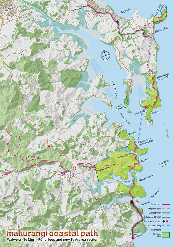
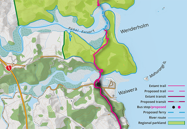
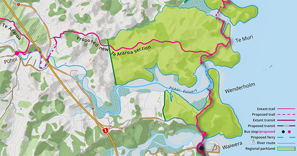
Actual, Conceptual, and Proposed: The almost completely unmodified coastline between Mahurangi Island and Mullet Point is already predominantly regional parkland and traversed with existing trails. Connecting the parkland could commence at either the Pūhoi Estuaryin version submitted: the river, stream, or harbour, Te Muri Estuaryin version submitted: the river, stream, or harbour, or Mahurangi Harbourin version submitted: the river, stream, or harbour. However, the least costly, most equitable, and lowest-carbon crossing, hands down, is a ferry from Wenderholm across the estuary to Te Muri. A year or two of use would demonstrate the scale of demand, and indicate how that might best be accommodated. With 27 regional parks accessible by private light vehicle, for one to be tailored for public-transport access would begin to signal the climate emergency being taken seriously.
map Mahurangi Magazine |basemap Land Information New Zealand
As of Friday 4 March 2022, the version lodged of what was a 12-week work-in-progress, is available in pdf format, titled
Coastal trail and the greater Mahurangi regional park – Joint submissionMahurangi Action Incorporated, the Mahurangi Coastal Path Trust, and the Mahurangi Magazine on Auckland Council’s draft management plan for the regional park network of Tāmaki Makaurau. The post-deadline commissioner summary excepted, the text of this online version is in the process of being updated to conform with that submitted.
Note For the purposes of clarity and consistency, Trail has been changed to Path, throughout this document, including to reflect the immediately subsequent name change of the Mahurangi Coastal Trail Trust to Mahurangi Coastal Path Trust, to reduce confusion with the Matakana Coast Trail Trust, which shared the same mctt initials.
Wenderholm, objectively, was where it started. While the 1729-hectare Centennial Memorial Park established in 1940 is recorded as Auckland’s first regional park, Wenderholm was the first of a half-century of regional parkland acquisitions that resulted in today’s 41 000-hectare network, much of it coastline, and most of that, Hauraki Gulf coastline.
Wenderholm, in 1965, and the on-average-every-other-year major park acquisition that followed, was the purchase that began the regional parks network that Aucklanders know and love. The purchase was thanks to the 1963 advent of regional governance, to belatedly back up regional planning. The finalas submitted: The last regional parkland purchase regional parkland purchase of the Auckland Regional Councilfrom 1963 to 1989 named Auckland Regional Authority, thereafter Auckland Regional Council. Subsumed by Auckland Council 2010, felicitously, was the 383-hectare Te Muri hinterland, immediately across the Pūhoi Estuary from Wenderholm. Wenderholm is nowsince the 2019 addition of the 92-hectare Turnbull-trusts-precipitated purchase on the Mahurangi Peninsula part of a contiguous—if intervening rivers, streams, and the Mahurangi Harbour are embraced—900 hectaresnot including Scandrett actual regional parkland or Scotts Landing Department of Conservation, pseudo regional parkland, 883 hectares of regional parkland. A signally salubrious place, surely, to plan for the management of regional parkland appropriate for this decadeeffectively, at least 2023–2033, by the time the draft is formally adopted, but without allowing for future plan-review slippage, which can result in 10-year plans prevailing for 15. So, in all probability, until the late-2030s…, and the beyond-urgent demands of the global climate emergency, this century.
Acute awareness of the rapid post-war spread of vacation settlements targeting the east-coast beaches north of the Tāmaki Makaurau isthmus spurred the purchase of Wenderholm. Without the newly created Auckland Regional Authorityfrom 1963 to 1989 named Auckland Regional Authority, thereafter Auckland Regional Council. Subsumed by Auckland Council 2010, and the provisions of its deliberately crafted empowering legislation, Wenderholm’s fate as a coastal subdivision could not have been circumvented. Wenderholm Regional Park opened later the same year it was purchased, as an early, and instantly beloved Christmas present. What followed, almost miraculously, has set the scene for Wenderholm to headline a regional-park-led revolution in how a metropolis can live, equitably, within its carbon means—at a time when climate, climate adaptation, and climate action are elsewhere combining to cruelly exacerbate societal inequity.
This submission was published progressively by the Mahurangi Magazine from 20 December 2021 onwards as a work in progress, both in the interests of painstaking transparency and in the hope that people passionate about salvaging a survivable climate, one Mahurangi regional park at a time, would contribute. The submission is submitted as that of Mahurangi Action Incorporated, the Mahurangi Coastal Path Trust, and the Mahurangi Magazine—each entity desiring to be heard separately in support of the aspects that most exercise it.
Note In the interests of readability, throughout the balance of this submission, the Draft Regional Parks Management Plan prepared by Auckland Council is referred to simply as the draft plan.
In this submission, Te Muri Crossing refers to the planned boardwalk and footbridge crossing of Te Muri Estuary.
Draft-management-plan Auckland Council’s draft Regional Parks Management Plan, issued for public consultation 10 December 2021 submission contents
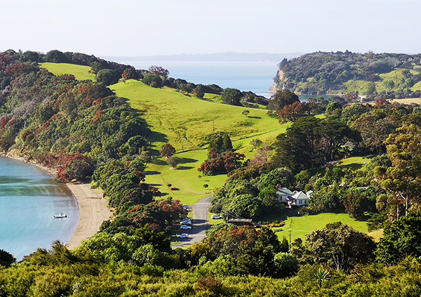
More Regional Parkland for the People: Good things take time, particularly when regional parks funding is parsimonious. However, just in time for a summer when every metre of physical distancing would count towards mitigating covid-19 community spread, the thousands who visit Sullivans Bay – Ōtarawao had at least twice as much room to picnic, adjacent the southern end of the beach. The concept plan that included this and other changes was canvassed nearly five years ago. That private-light-vehicle parking is taking a back seat will alarm some, but without more equitable means of access to the 41 000-hectare regional parks network, the prime parkland will increasingly be occupied by vehicles rather than people.
image Mahurangi Magazine
This, in part, is the tale of two regional parks—the first and the last acquired during Auckland’s 36 years of regional government. The first is well known Wenderholm and is massively visited. The last is Wenderholm’s little-known, little-sister Te Muri, smack next door, but separated by the Pūhoi Estuary. An estuary crossing, whether by footbridge or by ferry, will put park users within a short, family-friendly walk of a beach that invariably astonishes, with its sense of splendid isolation.
Despite its proximity to popular Wenderholm, Te Muri Beach has lacked all-tide access since its purchase for the public 49 years ago. This is about to change, trialled, if not by the end of this summer, then by early next, thanks to the community’s commitment to acquire a surplus-to-operations regional parks landing barge.
If all the Pūhoi Estuary crossing achieved was Te Muri accessed—equitably, via public transport to Waiwera—it would be worth the weight of the aluminium barge in gold. But, by linking 900 hectares of contiguousconsidering intervening rivers, streams, and the Mahurangi Harbour to be connecting rather than dividing regional parkland, by connecting Te Araroa, the national walkway, by creating the Wenderholm – Te Muri – Pūhoi loop, and by catalysing a Waiwera to Waipū coastal trail of national importance, an embarrassment of benefits accrue.
If the above sounds too good to be true, that is because it belies the rigour required to produce coherent management-plan policy in respect to the climate emergency and equity of access—generally, and across the policy for the entirety of the greater Mahurangi regional parkland—and the imagination, and commensurate courage to implement it.
Consciously coastal Path-centric perspective Utterly mindful that the review of the regional parks management plan is an omnibus process, this submission is an entirely consciously Mahurangi Coastal Path-centric perspective, of the draft planAuckland Council’s draft Regional Parks Management Plan, issued for public consultation 10 December 2021. The importance of the planned coastal trail, to the 900 hectaresnot including Scandrett actual regional parkland or Scotts Landing Department of Conservation, pseudo regional parkland, 883 hectares of regional parkland it would ultimately link and its visitors, and to the adjacent communities connected, is so considerable that it would be perverse to fail to employ this approach. As an exemplar for the Tāmaki Makaurau region and beyond, the Mahurangi Coastal Path concept provides a fresh, outside-in vision of the future of the regional parks network.
The three submitors trust that other submissions, both regional-park specific and general—notably that of Friends of Regional Parks—and combinations of the specific and general, will more than comprehensively cover policy and plans ignored by this Mahurangi Coastal Path-centric submission.
This work-in-progress commissioner, or hearing, summary is not part of the submission lodged, but is added here to address the inadequately brief executive summary. The executive summary, which fell well short of its putative purpose, is probably better described as an elevator pitch.
Beginning with the bullets Sensibly, a Mahurangi Magazine reader exercised about the need for a considerably less sparse executive summary, suggested beginning by bullet-pointing the submission’s main contentions. Again, reminding readers that this commissioner summary is a work in progress, the following is an early attempt at distilling the ~15 000-wordjoint submissionMahurangi Action Incorporated, the Mahurangi Coastal Path Trust, and the Mahurangi Magazine:
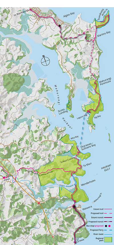
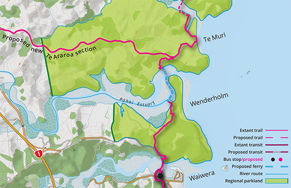
Coastal Path and the greater Mahurangi Regional Park: Nothing another 12-weeks wouldn’t have fixed, this map—focussing more closely on the coastal trail and the Mahurangi regional parkland that it will connect—if it had been included in the joint submissionMahurangi Action Incorporated, the Mahurangi Coastal Path Trust, and the Mahurangi Magazine lodged, might have provided additional utility, and a little light relief for those willing, or obliged, to wade through its 15 000-odd words.
image Mahurangi Magazine
1
Equity of access equals public transport
Unarguably, the principal means of delivering equity of access is public transport—joined-up public transport. To date, proximate third-tier transit services, by themselves, have not proved to be sufficiently convenient to lessen regional parks private-light-vehicle dependency. This submission urges that the Mahurangi Coastal Path, and the magnetism of Te Muri provide a fertile opportunity to demonstrate how equity of access can be delivered to, through, and to link, regional parkland.
2
Equity of access and honest climate-emergency action complementary
Honesty concerning the climate emergency demands other-than virtue signalling, such as with ev-charging in regional park car parks. Rather than further contribute to the now deeply problematic private-light-vehicle-centric regional parks model, Te Muri and the Mahurangi Peninsula, which don’t have currently have road access, are perfect candidates as low-carbon, equity-of-access exemplars.
3
Great regional park potential inestimable
While urban-scale parks and even pocket-parks provide critical respite in urban areas, great parks—national parks, regional parks—define the character of a place and its populace. The people of Tāmaki Makaurau, particularly the young people of the metropolis, deserve to know they are visiting, or contemplating visiting, a 900-hectare greater Mahurangi regional park. Failing to consider the greater Mahurangi regional parkland one, during the 1967–1970 Mahurangi West acquisitions, was perhaps understandable. With the 2010 and 2019 acquisitions, however, came the duty to remedy the perverse and arbitrary diminishment of the mana of a great regional park. This review, at the very least, should signal the beginning of an exploration of the near-inestimable, greater Mahurangi regional park potential.
4
Connecting the regional to the national, walkway
Connecting the regional parks network’s most desirable beach to Pūhoi—facilitated by the Mahurangi Coastal Path—addresses the current deeply problematic Te Araroaby-pass, which forces walkers to struggle along inhospitable highway shoulders, when they should be enjoying the last substantive, sublime stretch of unbuilt coastlime before entering the metropolis. Conversely, the citizens of Tāmaki Makaurau are connected to that coast, and to Te Araroa.
5
Community-actioned trial of the coastal trail
With the pending purchase of the surplus-to-regional-park-operations landing barge by community completed, trialing of the Mahurangi Coastal Path will be able to begin, early next summer. At virtually no cost to Auckland Council, and permission gained for the installation of one stile, members of a 48-year-old community organisation will trial climate-emergency-appropriate, equity-of-access access to Te Muri, via Waiwera. Based on the anecdotal feedback received, proponents of the trial have reason to believe the coastal trail – Te Muri – greater Mahurangi regional park – Te Araroa combination will prove irrisistable.
6
Save a walkable Hungry Creek Road
Singularly the most inconsistent and unsound policy proposal contained in the Draft Regional Parks Management Plan, concerning the greater Mahurangi regional park, is that whereby Hungry Creek Road would provide private-light-vehicle access to a “main arrival area” near the western boundary of Te Muri Regional Park. Inconsistent, because Auckland Council would be making a mockery of its proposed climate action targeted rate, by the access-inequity-exacerbating commitment to spend tens of millions of dollars to rebuild Hungry Creek Road for two-way vehicular traffic. Unsound, because it would squander the potential of Te Muri and its scenic ridge farm road to replace the current hazardous and inhospitable Te Araroaby-pass grudgingly provided by the shoulders of State Highway 1 and the Hibiscus Coast Highway.
Connected Council Climate Action: A sprinkling of ev-charging points and battery-powered buses, and drop-in-the-bucket tree planting, is virtue signalling unbecoming of Tāmaki Makaurau. Electrifying the Northern Busway, on the other hand, would significantly slash fossil fuel use, both for commuters and for regional-park users—provided that the first transit tier connected to the fourth. Suboptimally, for Aotearoa and other hold-out left-hand-traffic countries, the choice of double-sourcedouble-source refers to the battery auxiliary that enables these buses to reach areas not serviced by overhead power wires (catenary) trolleybuses is not as great as in Europe, where transit rationality and trolleybus use is more likely to reign. The image here is laterally reversed, to put the five sets of double-opening doors—which, in concert with the vehicle being single-decked, are key to minimising bus-stop dwell time—on the left, platform-side of this 24.7-metre bi-articulated Trollino 24 trolleybus.
image Sustainable Bus | recolour Mahurangi Magazine
Judge Arnold Turner Footbridge and the J Barry Ferguson Six or seven years before naming a ferry the J Barry Ferguson was considered, the intention was to name the proposed Pūhoi Estuary crossing, the Judge Arnold Turner Footbridge. When the 2016 footbridge proposal failed to attract the universal support of those holding mana whenua, it was shelved, with Mahurangi Coastal Path Trust pursuing the Auckland Council officer-recommendation to explore a cable-ferry alternative. The subsequent availability, however, of a 4.9-metre surplus-to-regional-parks-operations aluminium landing barge led to Mahurangi Action Incorporated undertaking to purchase the vessel and to trial the service with its members. With good grace, a local benefactor of the planned Mahurangi Coastal Path has agreed that his name be used to replace that which was no longer appropriate—Park Ranger. The trial will help determine whether a ferry service, longer-term, is sustainable or whether an elegant Judge Arnold Turner footbridge, well upstream, might need to be rigorously reconsidered.
Commissioner-summary conclusion Its writers would have greatly preferred to conclude this Draft Regional Parks Management Plan commissioner summary on an entirely laudatory note. However, without imparting the importance of Hungry Creek Road to regional-park equity of access, and to robust climate-emergency action, the production and presentation of the joint, ~15 000-word Coastal Path and the Greater Mahurangi Regional Park joint submissionMahurangi Action Incorporated, the Mahurangi Coastal Path Trust, and the Mahurangi Magazine will have largely been in vain.
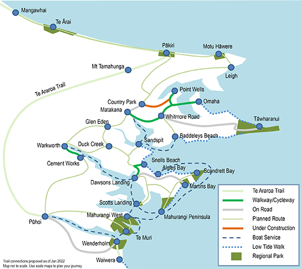
Network of regional parks and Trails: In the four decades it has taken to commence the Mahurangi Coastal Path in earnest, the broader Mahurangi region has mobilised to build a veritable network of trails to link communities with each other and to their regional parks.
schematic Mahurangi Trail Society
As alluded in the introduction, a signal opportunity exists to showcase an at-scale regional-park response to the climate emergency and to the urgent need to improve equity of access, commencing at the first modernWenderholm Regional Park: the first acquired commencing a 45-year period of regional parkland acquisitions that were part-and-parcel of Tāmaki Makaurau’s first period of regional governance Tāmaki Makaurau regional park. When Wenderholm was acquired in 1965, regional park visionaries were already imagining that magnificence extend farther up the coastline, accessed by a scenic coastal road. However, even by the time the protracted process of acquiring the next section of coastline, Te Muri, was completed, the appetite for coastal-road building for scenic purposes had been lost, assisted by the first oil crisis, in 1973. Although the community has advocated for the planned Mahurangi Coastal Path since 1987, wider enthusiasm to realise it has only recently gained critical mass, marked by the 2019 memorandum of understanding between Auckland Council and the Mahurangi Coastal Path Trust. Credit for that milestone goes to Auckland Council’s Pūhoi–Pākiri trail programme, a New Zealand Walking Access Commission – New Zealand Transport Agency, Pūhoi-to-Pākiri project response.
Meanwhile, minus its 1.4-kilometre harbour mouth, the magnificent 13-kilometre Mahurangi coastline from Mahurangi Island to Mullet Point, is regional parkland extending inland an average of 800 metres~787 metres. Despite that embarrassment of coastal parkland riches, coastwise connectivity is impoverished, and regional-park user interaction with the local economy almost non-existent.
Specifically the draft planAuckland Council’s draft Regional Parks Management Plan, issued for public consultation 10 December 2021 should include background information to provide the context for the planned Mahurangi Coastal Path, linking the first and last acquisitions of the regional governance era, and contributing to the council’s Pūhoi to Pākiri project.
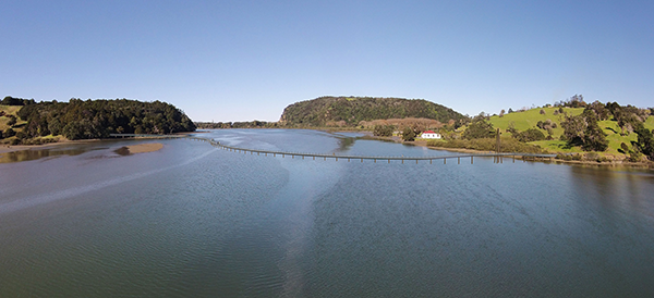
Fifteen Minutes to Splendid Te Muri Isolation: Once ferried across Pūhoi Estuary, it is a mere 15 minutes—even with pauses to gaze back at Wenderholm—before the primary goal of most people walking the Mahurangi Coastal Path, Te Muri, is a gentle 10-minute amble down to its sublime beach.
image Mahurangi Magazine
The immediate goal of the planned Mahurangi Coastal Path is to connect 900 hectaresnot including Scandrett actual regional parkland or Scotts Landing Department of Conservation, pseudo regional parkland, 883 hectares of contiguousconsidering intervening rivers, streams, and the Mahurangi Harbour to be connecting rather than dividing regional parkland. As an almost immediate consequence of those connections, Te Araroa, the national walkway, is provided with a new terrestrial section to Wenderholm, via the expansively scenic Te Muri ridgeline farm road. Simultaneously, a 17-kilometre scenic-ridge-road and Pūhoi River loop is created—powerfully complementing long-established Pūhoi-based kayak hire services.
The ultimate goal of the Mahurangi Coastal Path is to help catalyse a Waiwera to Waipū coastal trail of national importance. Such a trail would connect a further five regional parks, before it crossed the northern boundary of Tāmaki Makaurau.
Aside from the potential to catalyse a coastal trail of national importance, the intrinsic power of the Mahurangi Coastal Path concept is that not only does it link 900 hectares of regional parkland, it is the only way those 900 hectares of regional parkland can be linked, for terrestrial park visitors—kayak users, by definition, already enjoy such linkages. By road from Sullivans Bay to Martins Bay, for example, is a tortuous and often-congested 32 kilometres. By the ferry proposed, to Lagoon Bay, it is little more than a nautical mile1.27 nautical miles, or 2.35 kilometres. A coastal trail in no danger of being dogged by a parallel road presents an exquisite incentive for active recreation. The sense of achievement of attaining a destination, where the reward for effort cannot be diminished by vehicles pulling up at the same spot, is immense, and the public health benefit, for example, realistically quantifiable.
Specifically the draft planAuckland Council’s draft Regional Parks Management Plan, issued for public consultation 10 December 2021 should include policy to investigate how the planned Mahurangi Coastal Path can contribute substantively to the imperatives to respond to the climate emergency, sea-level rise, equity of access, and public health on a non-trivial scale.
4 Mahurangi Coastal Path Trust – undertaking to build and gift to Tāmaki Makaurau
In 2015, after collaborating on the planned coastal trail for four years, Mahurangi Action and Friends of Regional Parks resolved to establish the Mahurangi Coastal Path Trust.
The Mahurangi Coastal Path Trust believes that it is a conspicuously self-evident travesty that the Mahurangi coastline preserved as regional parkland cannot be traversed, end-to-end, on foot. Mindful of Auckland Council’s minimal budget and appetite for regional parks capital expenditure, the trust, in 2019, resolved to plan, gain consent for, build, and gift to the region, the planned Te Muri Crossing.
In July 2021, in response to community concern that Te Muri Crossing, if built first, would generate an undesirable increase of vehicle movements on the scenic ridge road leading to it at Mahurangi West, the trust resolved to open Te Muri Crossing only as part of an end-to-end Waiwera to Mahurangi Peninsula coastal trail.
Although termed the Mahurangi Coastal Trail, the planned route prioritises family-friendliness and accessibility. Riskier and/or more strenuous, cliff-edge, routes are, of course, the prerogative of the informed, individual park user.
Since the 1970s: The first beguiling section of the Mahurangi Coastal Path was built by students within the first decade of the coastal Auckland Regional Parks era. Tantalisingly, just across the Pūhoi River, which was, in the 1970s, touted to be crossed by a new scenic coastal road, lies one of Auckland’s best-kept secrets, in public ownership for 49 years, but yet to be provided with all-tide access.
map Mahurangi Magazine |basemap Land Information New Zealand
Waiwera to Wenderholm Jetty Waiwera, not least of all because its sea-stack-sentinel Mahurangi Island is the coastal trail’s namesake, is considered the beginning of the planned Mahurangi Coastal Path. Waiwera is also the most proximate public transport terminus for the populous Tāmaki Makaurau isthmus.
Waiwera River is safely crossed by a steel-safety-barrier-protected footpath on the road bridge carrying the Hibiscus Coast Highway. From that point on, walkers are in the greater Mahurangi regional park until emerging most of the way to Martins Bay, 8.4 kilometres north-northeast as the kuaka flies. Including the 350 metres from the bus stopStop 4793, Route 981 to the park boundary, the first gentle leg to Wenderholm Jetty is two kilometres, via the easier, western segment of the Perimeter Track.
Pūhoi Estuary crossing As a possibly interim expedient, rather than cross the broad Pūhoi Estuary via a footbridge, the Mahurangi Magazine proposes that a ferry service be provided to an imminently accessible location on the northern shoreline—an about 800-metre run. There, rather than construct a jetty that would need to be as lengthy as the 70-metre Wenderholm Jetty, an extant, shallow-draft landing barge will be trialled—see Interim-Ferry footnote to this section.
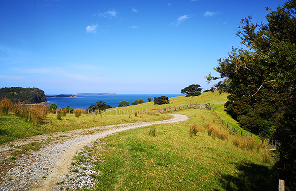
Pōhutukawa Landing to Te Muri Saddle Although the destination of the great majority of Mahurangi Coastal Path users will be Te Muri Beach, there are valid reasons for describing it in two legs. Walking steadily, Pōhutukawa Landinginterim name only to Te Muri Saddle takes about 15 minutes, but it should take at least 20, with breaks at closely spaced seats, to soak in the indisputably best vistas of Wenderholm. The maximum gradient, at almost one metre in four, is considerably steeper than desirable for walking or even e-biking, hence the need for frequent license to comfortably steep in the increasingly breath-taking panorama. Once past the steepest 40 metres, the gradient is a gentle less-than-one-in-ten, but the need for places to pause comfortably are no less, given the duty to
gaze back at Wenderholm and the Pūhoi Estuary.
Third Time Lucky Te Muri: Provided that it is accessed other than by private light vehicle, Te Muri will retain its sense of splendid isolation. First in 1980s, and again in the 2010s, regional parks planners sort to impose a car park on Te Muri. Now the climate emergency and equity of access must finally cross new car parks off the list, in favour of those who would gladly walk, from the bus stop nearby at Waiwera, or avail themselves of a fourth-tier targeted service to the Wenderholm Jetty.
map Mahurangi Magazine |basemap Land Information New Zealand
Te Muri Saddle Dramatically, at the saddle to Te Muri the panorama switches from estuarine to coastal, stretching northeast past Mahurangi Harbour’s Cudlip Point, Saddle Island – Te Haupa, Motuora and across the outer Hauraki Gulf to the great barrier island of Aotea, and nearer, the mountainous climax of the peninsula named for the spar ship Coromandel.
The saddle is also the confluence of the coastal trail planned and the national walkway—Te Araroa—addressed in the following section.Te Araroa walkers converging at that point will have been drinking in the coastal vista for the previous kilometre.
Te Muri Saddle to Te Muri Beach The gentle, ten-minute downhill walk through open pasture to the beach deserves to be savoured for the coastal vista revealed at the saddle, but few will, such is the allure of Te Muri. Seats, provided for the return walk to Te Muri Saddle, will encourage some, at least, to linger and appreciate at leisure. Use of the farm road that connects to the free-draining sandy coastal terrace could provide an all-weather interim route to the beach. Longer term, however, the all-weather surfacing of the more scenic, and gentler, route to the south is to be greatly preferred.
Te Muri Beach Its sense of splendid isolation is the reason venerating the ¾-kilometre730 metres, walked the almost straight length of its sand-long Te Muri Beach has become a religion, over the 49 years since it was acquired for the public as regional parkland. As briefly addressed in section 9 – Te Muri Regional Park, both the sense of splendid isolation and the environment of Te Muri Spit are threatened—terminally, in respect to the latter. The Mahurangi Coastal Path, consequently, traverses less than the full length of the beach, to avoid impacting the ecologically sensitive spit end, and the exquisitely culturally sensitive urupā, within 50 terminally receding metres of it. Sea-level rise, of course, has drastically increased the vulnerability these already naturally sensitive sites.
Te Muri Beach to Te Muri Crossing Leaving the beach, the trail crosses the spit, a currently mostly treeless expanse. Whether as part of the trail development as part ortypo, of, picked up by subeditor, but editor subsequently failed to implement retiring the current pasture in favour of restoring indigenous back-dune forest, this 150-metre section would greatly benefit from the sort of canopy provided at Wenderholm, by its open forest of pōhutukawa. Once across, the trail crosses the upper reach of an arm of the estuary via a low, relatively recently constructed wooden farm bridge. After 200-metres of winding, shaded farm track, the trail crosses the 3.4-hectare historic Nokenoke Block. In common with the first part of this section, the route would greatly benefit from trees planted for shade.
Planned Te Muri Crossing As regards planning, and disregarding the existing 2.9 kilometres of formed trail or footpath south of the Mahurangi Harbour, the planned boardwalk-and-footbridge Te Muri Crossing is currently the most advanced, substantive, infrastructure, in respect to the design, impact studies, and community, stakeholder, and treaty partnership consultation. The planned 260-metre boardwalk and footbridge is a major, $1 million commitment that, as mentioned earlier, is being undertaken by the Mahurangi Coastal Path Trust as a gift to the beneficiaries of the regional parks network of Tāmaki Makaurau. A baby step, however, towards the end-to-end, 8.3-kilometre Waiwera to Mahurangi Peninsula coastal trail, might be Waiwera to Te Muri. This could be accomplished at a cost closer to $0.25 million, than the $1.25 million that opening Waiwera to Mahurangi Peninsula, end-to-end, would likely entail.
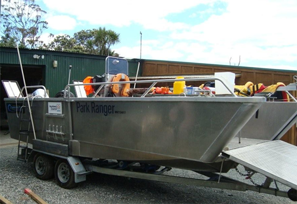
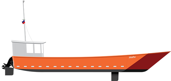
Robustly Functional Park Ranger: Purpose-built to survey in 2012, to service Mahurangi Peninsula regional parkland, the Park Ranger , having become surplus to operations is being purchased by the community to finally have the Mahurangi Coastal Path in use—in trial use, at least—four decades after its inception.
image Auckland Council
Waiwera to Te Muri The new infrastructure involved to trial an all-tide Waiwera to Te Muri trail consists of the surplus-to-council-operations landing barge Park Ranger, currently being purchased by the community, and a stile. Longer term, for an all-tide ferry to operate on a hire-or-reward basis, a significant jetty a 70-metre long structure, unless built near or at the rivermouth would probably be required to be constructed, to reduce the potential for stranding parties.
A particular value in phasing the development of the Mahurangi Coastal Path, starting with Waiwera to Te Muri, aside from it being a much more modest fundraising challenge, is that it will test demand for accessing Te Muri, other than by private light vehicle, via Mahurangi West Road and Ngārewa Drive. The ferry will be a powerful tool to deploy in demonstrating the coastal trail to those whom proponents of the Mahurangi Coastal Path hope to convince of its potential—whether folk exercised about local impacts, local business owners, council officers, local board members and councillors, funding institution executives, the mayor, mps or representatives of mana whenua. Provided that plenty of time is taken to tackle the farm road to Te Muri Saddle—the views back to Wenderholm helping hugely with this—even the staunchly sceptical would be won over, long before so much as putting a toe in the water, at Te Muri Beach.
Best Current Thinking 2016: Before being informed that a previous utilitarian iteration had failed to find favour with decision makers, this more elegant, suitably serpentine concept was rendered and proffered. Its swing-opening section, right, is in the spirit of the steamboat-era main-highway swing bridge near Pūhoi, before a flood carried it awayThe non-opening replacement bridge sealed Pūhoi off from subsequent steamboat deliveries, except to the extant wharf constructed, downstream of the former motorway toll payment kiosk.. Although few craft venturing farther upstream than this proposed location are sufficiently lofty to require the span to be opened—kayaks make up almost 100% of the present Pūhoi River traffic—it would be monstrously disrespectful to the Pūhoi River to deny access to the likes of the scow Jane Gifford.
rendering Littoralis Landscape Architecture
Pūhoi Estuary footbridge revisitation Setting aside limitations such as daylight hours of operation and extreme weather, any ferry service across the Pūhoi Estuary is likely to be soon overwhelmed by weekend and holiday demand. This, inevitably, would fuel pressure for the provision of a footbridge—an entirely uncontroversial solution in most park environments. Other options exist, of course, including a gondola lift. Options such as a gondola, however, would likely impose visitor levels on Te Muri akin to building a carpark beside its beach.
Aside from a Pūhoi Estuary footbridge being a very significant project to plan, consent and fund, the ferry-first trial will provide generous opportunity to canvas options, and to build the substantial potential-user-base desirable to demonstrate demand.
Te Muri Crossing to Sullivans Bay – Ōtarawao Provided that it followed rather than preceded a substantial means of crossing Pūhoi Estuary, the Ōtarawao – Te Muri section of trail would, potentially, and in conjunction with other equity-of-access measures, reduce private-light-vehicle traffic on Mahurangi West Road and Ngārewa Drive. The Scotts Landing free-regatta-shuttlebus lesson suggests that, in time, avoiding the growing congestion and fight for parking at Sullivans Bay could well result in a community-run shuttle becoming the preferred way for locals to access the park, particulary in peak periods.
Ōtarawao – Lagoon Bay Crossing the Mahurangi Harbour, Ōtarawao – Lagoon Bay, is a nominally 10-minute trip, in the craft that Mahurangi Action will be trialling the service. Load, sea-state, wind, and anchored boats will of course, from time to time, dictate a slower trip. Although a very small segment of the time taken to walk from Waiwera to, say Big Bay, the cross-harbour ferry will provide a profound sense of the harbour’s scale, only apparent proceeding by watercraft, as opposed to viewing it from elevation.
Lagoon Bay – Big Bay Many Mahurangi Action members who participate in the first couple-or-three-year trial of the landing-barge service will be Big Bay-bound, a 0.8-kilometre, 17-minute walk. Because it is not a big detour for those walkers headed farther north, some of those, no doubt, will take the opportunity to regain the coast, possibly to walk—tide permitting—the littoral rock platform, in preference to the ridgeline.
Lagoon Bay – northern park boundary The initial climb from Lagoon Bay zig-zags to a spur of the main spine of the peninsula, relatively gently reaching its highest, 105-metre, point after 1.2 kilometres. The trail from there, traces the ridgeline, which, favouring the seaward side of the peninsula, provides endless coastal panoramas. After 2.6 kilometres, the northern park boundary is reached, and the road, from there runs, unfenced, through private farmland.
Northern park boundary – Martins Bay Long term, the acquisition of the Becroft and Nichols property presumably means that walking access can be developed from the northern park boundary to Martins Bay. This will nicely connect, via the foreshore, to Scandrett Regional Park. In the interim, however, the fourth-tier targeted service that would be needed to connect even from Scandretts Bay to the transit terminus at Algies Bay, can, with a suitable vehicle, run the entire 6.8 kilometres.
Martins Bay – Algies Bay The final leg will leave walkers wanting more, with the scenic and elevated ridge road to Algies Bay providing almost dangerous servings of Kawau Bay eye candy.
Interim-ferry footnote As suggested above, an expedient, interim Pūhoi Estuary ferry service is set to be trialled. Operating from Wenderholm Jetty, commencing 2022, the shallow-draft ferry to be deployed can readily land coastal-trailhyphenate post-submission inductees on the northern estuary shoreline, within a breathtakingly scenic 30-minute walk to Te Muri Beach without additional infrastructure greater than a stile. Such a service will quickly and definitively gauge regional-park-user appetite for private-light-vehicle-free access, via Waiwera.
A variety of craft—in addition to the shallow-draft, lowering-bow-ramp barge in the process of being purchased—should eventually be evaluated. However, the craft available, having been purpose designed to service the Mahurangi Peninsula from Ōtarawao, is well suited to the task of pioneering the Mahurangi Harbour crossing without which a Mahurangi Coastal Path, Mahurangi Island to Mullet Point, cannot readily be demonstrated.
Specifically the draft planAuckland Council’s draft Regional Parks Management Plan, issued for public consultation 10 December 2021 should include policy to support the trialling, in the near term, of a Mahurangi Coastal Path, Mahurangi Island to Mullet Point—Waiwera to Algies Bay, to help gauge potential for regional park transit-access options.
6 Regional-park gateway to Te Araroa, the national walkway
Te Araroa walkers reconnect with the coastline at or near Wenderholm, three daysthe better part of and 60 kilometres after leaving it at Pākiri. Most will have replenished provisions at Pūhoi, in all probability in anticipation oftypo: of a, picked up by subeditor, but editor subsequently failed to implement camping more than one night at Te Muri Beach before braving the metropolis on foot. All this presumes, however, availability of a Mahurangi Coastal Path. Meantime:
Nor does the hazard begin there. First, walkers must risk the kilometre from Pūhoi to the highway, parts of which have unwalkable shoulders, short sight lines, and carry often fast-moving commuter traffic. Rejecting the official recommendation to kayak, most walkers, walk. Additionally, the major part of the route, which is along the Hibiscus Coast Highway, is no safer than the soon-to-be-retired section of State Highway 1 involved. Having completed less than 17.5% of the Cape Reinga to Bluff trail, most Te Araroa walkers are husbanding their time and finances for the nearly 2500 remaining kilometres ahead. Waiting to catch the next outgoing tide, much less outlaying for kayak hire, is an option few choose.
Despite it being walked, by a few, since 2003, and being formally opened a decade ago, most Aucklanders are unfamiliar with the name Te Araroa, and much fewer have knowingly walked so much as a section of it. Plenty will have unknowingly walked urban sections, but Wenderholm – Pūhoi is the first, sublime, non-urban section, north of the metropolis. Commencing from within the greater 900-hectarenot including Scandrett actual regional parkland or Scotts Landing Department of Conservation, pseudo regional parkland, 883 hectares Mahurangi regional park, it would be impossible to devise a more magnificent entrée to New Zealand’s 3000-kilometre long walkliterally, in te reo Māori: araroa = walk long, for the inhabitants of its most populous region. After two decades of formal and informal use, end-to-end Te Araroa walkers have only recently exceeded 1200 per year. If walking Te Araroa became the rite-of-passage aspiration of all young people born in Aotearoa, as it utterly deserves to be, up to 60 000 of those walking Te Araroa of a year would be New Zealanders, and most of those Aucklanders. This is the gift that Te Muri and the greater Mahurangi regional parks can bestow the national walkway of Aotearoa.
Loop to Introduce Every Aucklander to Te Araroa: Te Muri and its scenic ridge farm road to Pūhoi would instantly become Aucklanders’ first, magnificent non-urban experience of Te Araroa, the national walkway. The Wenderholm–Te Muri–Pūhoi loop formed by the Pūhoi River would robustly build on the long-established Pūhoi–Wenderholm kayak business recently experiencing unparalleled, pandemic-fuelled patronage.
map Mahurangi Magazine |basemap Land Information New Zealand
If Te Muri linked to a cruel slog, such as that which commences Te Araroa at Pākiri, where the trail is obliged to follow a fence line up the unrelenting north face of Pākiri Hill, it would be walked—climbed, is the term used in the official trail notes—but only by a tiny percentage of the more than a quarter of a million visitors Wenderholm receives every year. From Pākiri to the Dome Valley is a demandingslippery is used four times in the official trail notes 10–12-hour tramp, with the only facilities available being two long-drop toilets, a dearth of camp sites, nor anything purchasable until the Dome café.
Wenderholm Jetty to Te Muri Beach The less-than-two-kilometre, ferry and trail Wenderholm Jetty to Te Muri Beach leg is described earlier. Assuming a moderately full tide and being among the last aboard the ferry, a person could comfortably make Te Muri Beach in half an hour.
Te Muri Beach to Te Muri Saddle Te Muri, in sublime contrast to Pākiri, links to Te Araroa via a walk that gently rises from the solitude of Te Muri Beach to the scenic ridge farm road. Even so, as mentioned earlier, frequent pauses to enjoy the coastal panorama are encouraged. Although the saddle is the intersection of Te Araroa and the Mahurangi Coastal Path, few will walk either the coastal trail, the loop trail, or Te Araroa without venturing to, and at the very least pausing at, the beach.
Te Muri Saddle to Hungry Creek Road Most of the 3.5-kilometre scenic ridge road from the saddle to the summit of Hungry Creek Road is all-but level, rising and falling less than 15 metres in 500 walked. The rearward, receding coastal vistas are handsomely replaced by terrestrial panoramas—the ridgeline that carriers the scenic Mahurangi West Road to the north, and glimpses of Pūhoi Estuary to the south. The last glimpse of that estuary includes the former Schischka farmhouse and, just upstream of it, the landform suggested, in 2016, as the natural southern abutment of a sympathetically serpentine footbridge estuary crossing—complete with pivoting section,technically a swing bridge, but too readily confused with the colloquial New Zealand term for a simple pedestrian suspension bridge echoing that which once crossed the river near Pūhoi.
Hungry Creek Road to Hungry Creek After the nominally 2.2-kilometre level run—3.5 kilometres from the beach—the scenic ridge farm road meets Hungry Creek Road at the western boundary of the regional parkland. Little used, Hungry Creek Road is imminently suitable for walking, cycling and horse riding, provided that it is not promoted as private-light-vehicle access to Te Muri Regional Park. Exiting the park, the trail ultimately descends from an elevation of 115 metres to sea level, at Hungry Creek. However, the first 620 metres, after falling briefly, rises to the highest elevation of the Te Muri Beach to Pūhoi journey: 137 metres. From there the descent to sea level is abrupt. The road falls at an average gradient of 1:8, and for a 108-metre section, at 1:7—almost twice as steep as the maximum 1:12 recommended for short distances. At places the road is also traversing topography up to 33° from the vertical.
To rebuild 2.2 kilometres of Hungry Creek Road and the farm road,220 metres and an extensionsay, 200 metres to it, to access the “main [Te Muri Regional Park] arrival area” proposed in the draft planAuckland Council’s draft Regional Parks Management Plan, issued for public consultation 10 December 2021—sufficient to safely allow two-way traffic that included horse floats—would involve tens of millions of dollars. The cost would be considerably greater if, simultaneously, provision was also made for safe pedestrian, cycle or bridle access. While the twin imperatives of climate response and equity of access would surely require it, it is instructive that Auckland Transport, when upgrading the road to Mahurangi West Regional Park in 2020, made no provision for pedestrians—this, despite Ngārewa Drive long being used by locals and park-visitor walkers alike.
Up Hungry Creek Road – The hard way Walked in the other direction, from Pūhoi to Te Muri Beach, the first 1.1-kilometre, 137-metre climb up Hungry Creek Road can fairly be described as a gut-buster. But rather than seek to engineer a 1:12 walking and cycling switchback pathway, the simple expedient of providing numerous bench-and-platform viewing points should at least be trialled. The view, although now dominated by the sweep of the Arawhiti ki Pūhoi motorway viaduct, is dramatic, and increasingly so with elevation. Designed appropriately, the bench-and-platform structure could retrospectively form part of a grade-separated pathway, should billions suddenly materialise for other-than-motorway infrastructure.
As mentioned above, a sizable section of the hill has a gradient of 1:7. Given that it is mandatory for even brief sections footpath with gradients of 1:6 to have handrails, the length of the climb—1.07 kilometres at 1:8, the handrail should probably effectively be continuous. Meanwhile, regardless of the direction by which the proposed Te Muri–Pūhoi loop trail is tackled, the frequent bench-and-platform provided primarily for the uphill slog, will be welcome enough for those nursing knees, or simply relishing an opportunity to pause for photography or refreshment. At least one toilet should be provided.
Hungry Creek and under State Highway 17 At the foot of Hungry Creek Road, two options exist for crossing what, in mid-May, will be relegated State Highway 17. By far the more elegant would follow the eastern bank of Hungry Creek by way of a paper road for 550 metres before crossing the stream at the mouth of its confluence the Pūhoi River. The cost of the 10-metre footbridge required to span Hungry Creek and the time and cost involved in consenting it possibly means that the crude alternative of walking beside State Highway 17 to the same point is adopted. This expedient would be unwise. With all the signs in the world, walkers would be tempted to cross the highway at grade, rather than simply duck under the highway bridge, safely grade-separated.
State Highway 17 to Pūhoi Once under the “old” highway bridge, and the new, lofty Arawhiti ki Pūhoi motorway viaduct, wonderfully, the trail into the heart Pūhoi Village simply follows the rural and forested true left bank of the Pūhoi River. On any given outgoing tide, in half-reasonable weather, walkers will pass a stream of kayaks. Charmingly, the final 300 metres of this 1.5-kilometre section runs through the Pūhoi Domain.
Pūhoi Village Traditionally, the settlers of Pūhoi frequented Te Muri Beach via Hungry Creek Road, on foot or on horseback. Until the 1930s, via Hungry Creek Road was also a traditional route between the Pūhoi and Mahurangi West communities. While the 1200 per year Te Araroa through-walkers must represent a tiny fraction of the visitors the legendary town receives annually, kayakers to and from Wenderholm, in contrast, make up an appreciable proportion.
Pūhoi to Wenderholm The two-hour kayak cruise from Pūhoi to Wenderholm, on a recently turned out-going tide, is about the most wonderful, individual way to complete the 17-kilometre Wenderholm–Te Muri–Pūhoi loop trail. Aside from longer canoes—waka would seem perfectly apposite—there is potential for more equitable means of undertaking this leg. A ferry, because it would need to be ultra-low-wake at the 5-knot maximum speed permitted, would also likely be canoe-bodied. The 50-minute journey, powered by battery, would be an entirely virtuous reward for the 9-kilometre walk that preceded it.
Wenderholm–Te Muri–Pūhoi loop trail – Conclusion Whether walked west to east as a Te Araroa through-walker, east to west as a Te Araroa first-timer, or purely for its standout standalone attractions, the proposed 17-kilometre Wenderholm–Te Muri–Pūhoi loop trail would be the diamond necklace to the jewel-in-the-regional-parks-crown that is Te Muri.
Specifically the draft planAuckland Council’s draft Regional Parks Management Plan, issued for public consultation 10 December 2021 should include policy to investigate the potential of the 17-kilometre Wenderholm–Te Muri–Pūhoi loop trail proposed, to showcase zero-carbon regional-park equity of access.
Wenderholm, unsurprisingly, considering its history in the eyes of Aucklanders as the first regional park, and its sublime geography, is believed by park managers to be over-capacity. This is probably indisputable in peak holiday and summer weekends. Much, however, can be done to comfortably accommodate more park users, including, of course, encouraging more use outside of peak periods.
In common with other immensely popular regional parks—famously, Long Bay—much of the prime picnicking area is used for private-light-vehicle parking. That was entirely appropriate to the 1950s vision for the regional
parks, when it was not an unreasonable assumption that every family would be
a car-owning family. The second half-century of regional parks development,
however, must be about concertedly addressing the transit-access deficit.
Access to the planned Mahurangi Coastal Path is in danger of being sacrificed by regional-parks-operations concern that any activity that might attract additional visitor numbers, at Wenderholm, must be discouraged. The planned trail, however, provides the perfect opportunity to trial transit-centric solutions that, potentially, provide a wholesome route towards reducing congestion and accommodating regional park visitors, simultaneously. It is entirely conceivable, for example, that a greater proportion of regular Wenderholm park users will become regular Te Muri users, than the general population of regional-park users.
Elegant Scow Before Plan-b Barge: Conceived to trial a reaction-ferry service at the Pūhoi Rivermouth, it was proposed that Mahurangi Action build this double-bow-door barge, styled to echo the Hauraki Gulf-scow heritage and to limit landscape and visual impact. Only a rivermouth operation, or an amphibious craft, could maintain a service on spring-low tides. Advice by Auckland Council that its aluminium landing barge had become surplus to operations with the acquisition of further Mahurangi Peninsula parkland, effectively shelved the elegant-scow concept.
design Mahurangi Magazine
Waiwera as departure point for Te Muri Serendipitously, in time to be included in this submission, confirmation has been received that the surplus-to-operations landing barge, designed and built to service regional parkland on Mahurangi Peninsula, has been approved for sale for Mahurangi Regatta and coastal trail purposes in community ownership. Operated initially on a charitable, by-arrangement basis, the barge will quickly and definitively gauge regional-park-user appetite for private-light-vehicle-free access to Te Muri, via Waiwera, as outlined earlier.
During the trial period, passengers will be required to be members of a Mahurangi Coastal Path supporters organisation, probably either a reconstituted Mahurangi Coastal Path Trust or the extant, fit-for-purpose Mahurangi Action Incorporated, currently in its 48th year. The members will be met at Waiwera—route 981, stop 4793—by an 11-seater minibus, to convey belongings and as many who prefer to ride rather than take the undemanding, 30-minute walk, to Wenderholm Jetty.
Specifically the draft planAuckland Council’s draft Regional Parks Management Plan, issued for public consultation 10 December 2021 should include policy supporting the trialling of an initial Waiwera to Te Muri ‘Phase 1’ Mahurangi Coastal Path, deploying the surplus-to-operations Mahurangi Regional Park landing barge, in community ownership.
Titling a location near its western-boundary “the main arrival area”, lamentably typifies how poorly the policies in the draft planAuckland Council’s draft Regional Parks Management Plan, issued for public consultation 10 December 2021, address the real-world needs of, and opportunities availed by, the 444 hectares of Te Muri regional parkland. If the western-boundary site so designated was to become the main arrival area, the essential essence of Te Muri will have not been best protected, to the detriment of future generations of its adoring adherents.
Its sense of splendid isolation is the overwhelmingly predominant reaction of first-time visitors, to Te Muri Beach. Preserving that rare quality, of a beach just 36 kilometres from the central business district of a metropolis that will conceivably be home to 5 million in the regional parks networks’ second half-century, must be the paramount mission of the policies affecting this deeply cherished location.
Preserving sense of splendid isolation paramount Realisation, in the 1980s, that the regional authority was intent on building a road to Te Muri to park 4000 cars immediately behind its beach, galvanised the community to protect that which it had instantly recognised was a rapidly vanishing experience for Aucklanders—an achievable beach that felt a million miles from the metropolis. After a second community campaign, culminating with the 2016 management-plan variation in respect to Te Muri, plans for private-light-vehicle parking adjacent the beach were finally abandoned, in favour of improved non-motorised access. The draw of the beach, however, inevitably ensures that it will be the primary goal of most who visit Te Muri. Astute, joined-up policy making has the potential to dissipate pressure on the beach and its immediate environs, and to spread the love slightly less unevenly, over more of its copious 444 hectares. Further, as opposed to treating Te Muri as a discrete regional park, by recognising that it is part of a 900-hectare regional-parkland whole, the temptation to cater for a little of every regional-park activity can consciously be avoided. For example, Te Muri is perfectly suited to camping, even to glamping, but self-contained-vehicle and other vehicle-based camping is better suited to where it already exists, at Mahurangi West and Wenderholm.
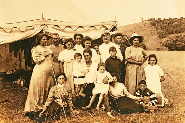
Fit for a Future Queen: While Queen Elizabeth II might have spent an afternoon resting at Wenderholm, the future Queen of Tonga, Sālote Mafile‘o Pilolevu, back row, third from left, actually camped here, next door at Te Muri.
image Greig Family Collection | Museum of Samoa
Prioritising remote camping Long before Mahurangi Regional Park opened officially to the public, Te Muri Beach was a camping mecca, and a beach-day destination, particularly for Pūhoi residents. But because then, now, and in the future, Te Muri Beach was, is and will be, more than a ten-minute walk, camping is, arguably, a better match than day visits, where the imperative is to provide the greatest depth of park-user experience, for the least destination impact—farm stay, compared to if-it’s-Tuesday-this-must-be… overtourism, so to speak. Despite the desirability of prioritising camping, picnicking space has the greater call on available land closest to the beach, whether for day visitors or campers. Campers, nevertheless, can be prioritised, epitomised by provisioning of, and by a camp store.
Te Muri Camp Store The twin imperatives of climate emergency and equity of access demand that current remote camping practises are scrutinised. Overall, the practices are heavily private-light-vehicle dependent. Typically, a party of campers arrives, over the course of one day, in various vehicles, to the parking area at the terminus of Ngārewa Drive. There, begins the—admittedly non-motorised—logistics of portaging tents, bedding, spare clothing, drink, food and condiments, cooking apparatus, dining ware and utensils and, not least of all, beach paraphernalia, to the campsite.
Within a day or two, the first of the minimum-47-kilometre reprovisioning runs to an Ōrewa or Warkworth supermarket and back will begin. These will typically be repeated every other day for the duration of the camp, for a combination of necessities and luxuries. This reality makes a mockery of the description of Te Muri as a remote camping experience, is climate-emergency contrary, and is patently inequitable in regard to access.
The outside-the-square solution advanced in the Mahurangi Magazine ’s 2016 submission, post the climate emergency declaration, is now even more apposite. A camp store, sited near the earlier of the two farmhouses, at an elevation of about 100 metres, would not only preserve, but positively enhance the remote camping experience. As part of the daily camping ritual, walking slowly up the hill to the camp store, for an early morning espresso, and the milk, bread and ice, or conversely in the cool of the evening, without the stimulant.
The store, of course, would be a boon to Wenderholm–Te Muri–Pūhoi loop and Te Araroa trail walkers. If sited where a farm shed currently basks in panoramic views of Te Muri Beach and the coastline northward, it would be a destination in itself, and hub of the community of Te Muri devotees.
Equitable Te Muri Beach access Key to ensuring a climate-emergency and access-equity step change, is a fourth-tier targeted service, almost to the beach, whether for campers and/or their burden of camping gear, or for those unable to readily walk in, via the coastal trail or from Pūhoi. Strictly limited to a maximum number of runs per day, the vehicle would be required to proceed exceptionally sedately and to grant right of way to walkers and horse riders—rules that should equally apply to cyclists, if allowed to use the scenic farm ridge road. The same vehicle would supply the camp store, conceivably by arrangement with the Pūhoi General Store.
The greatest service a fourth-tier targeted service could render remote-camping Te Muri equity of access would be by facilitating the delivery of, for example, wheelie-bin containers of camping gear, and their subsequent return.
Facing inevitability of unspeakable loss Admitting the inevitable loss of beaches such as Te Muri is cruelly confronting, and denial is understandable. As guardians of these finite treasures, the regional parks have a duty to administer every practicable balm, such as the restoration of indigenous sand-binding plants already prosecuted by regional parks operations staff with valour. Back-dune planting must also be prioritised. But nor can big-picture realities be glossed over, such as the fact of the private-light-vehicle-model that the regional parks network has been built on, over nearly six decades. While that addressing that is a systemic responsibility, morally, every regional park needs to play to its strengths to contribute to changing the model. At Te Muri it is simple. Deliver equity of access, by developing, in partnership with adjoining communities, transit connections, not new car parks.
Specifically the draft planAuckland Council’s draft Regional Parks Management Plan, issued for public consultation 10 December 2021 should include policy to investigate more profound ways of ensuring that the sense of splendid isolation that defines Te Muri is preserved, while providing equity of access and a proportionate response to the climate emergency.
Most-used area of the Mahurangi Regional Park, increasingly to the point of over-capacity, is Sullivans Bay – Ōtarawao. This, despite it being unavailable for trailered boat launching and retrieval, which activity, if permitted there, would dominate to the detriment of all other uses, including the hand launching of kayaks and myriad other small craft. In common with most coastal regional parks, Ōtarawao has limited terrain suitable for private-light-vehicle parking, and because few are able to practicably access the park by other means, parking occupies about half the space available for picnicking, lounging, and recreating.
Parking, picnicking, and camping Setting aside, for the moment, equity of access and climate-emergency considerations, Ōtarawao, of the three intimately adjacent beaches of Te Muri, Ōtarawao, and Mita, is considerably the most readily accessible to regional-park users. This suggests that of the three, Ōtarawao should be optimised for day visitors, particularly in periods of high demand. In periods of low demand, however, Ōtarawao vehicle-based camping could reasonably be allowed to a much greater extent.
Sullivans Bay – Ōtarawao capacity Whether because of pandemic-provoked changes in patterns of leisure activities or as a result of its already growing popularity, or a combination of those factors, Ōtarawaoknown more recently as Sullivans Bay by mana whenua but before that as Jacksons Bay, and, prior to settler influence, as Ōtarawao , in the experience of regular users, is often now at or over capacity. When seasonal farming operations monopolised much of the area available for private-light-vehicle parking in spring 2021, park users had an early taste of the future of Ōtarawao if available parking is allowed to dictate park capacity—kilometres of roadside parking and hazardous, on-foot, access to the beach area running a gauntlet of parked and manoeuvring vehicles.
Normally, introducing a fourth-tier targeted transit service or third-tier, would struggle to compete with the convenience of private-light-vehicle access. At Ōtarawao, however, the Mahurangi Coastal Path would generate its own demand, for example, coastal-trail users who had only had the time, energy or inclination to walk the trail in one direction. Here, and in other regional-park settings where fourth-tier transit is introduced, the opportunity for servicing the adjacent community should not be overlooked. Fourth-tier transit not only has the potential to deliver equity of access for locals to their regional parks, but to nearby towns. The pattern whereby older people are persuaded or caused to relocate away from their desired place of residence for the want of public transport is deplorable, as is the isolation of, or private-light-vehicle dependency of, children.
Bloody High-Carbon Path to Low-Carbon: Slashing greenhouse-gas emissions in the West without devastating the South requires that the copper-and-gold-hungry process of the electrification of everything not be squandered. Connecting electrified first-tier transit—trolley buses running on busways—to regional parks with, intermediary tiers, is meaningful climate action. Installing charging points for private light vehicles in park parking areas, is decidedly not. Panguna mine, Bougainville.
image rnz | Johnny Blades
Panoramic picnicking Combined, the coastal-terrace land that might be used for picnicking, lounging, and recreating in Ōtarawao and Mita bays is a mere 3.6% of the regional parkland there. With half of that, in Sullivans Bay, given over to roadway and parking, it is clear that, increasingly, more of the non-coastal-terrace land will need to be developed. While wholesale terracing of hillsides would create considerable picnickable area, cost and landscape and visual impact dictates that any sculpting of the clay would need to be constrained to picnic-blanket scaled sites. To encourage less concentration of use on the prime, coastal terrace parkland, however, facilities—toilets, in particular—need to be dispersed. Early candidate-sites are Cudlip and Tungutu points, locations a proportion of park users would visit, without contributing, even briefly, to the beachside congestion.
Lovely Mita, Mita Bay On a par with camping Te Muri, Mita Bay, or by its seldom used name Ōtuawaea, is a great candidate for a fourth-tier targeted service, given the general shortage of parking at Mahurangi West, but particularly in proximity to that popular camping ground. Rather than reiterate in detail here how campers might practicably, equitably access Mita Bay, and be the envy of those who are tethered there to a vehicle, readers are referred above to Equitable Te Muri Beach access. The pleasure would begin the instant campers stepped off the bus at Waiwera, content in the knowledge that when they arrive at their campsite their wheelie-bin container of gear, food and drink would be waiting there for them, secured and shaded.
Specifically the draft planAuckland Council’s draft Regional Parks Management Plan, issued for public consultation 10 December 2021 should include policy to prioritise Ōtarawao for day use, create disperse facilities picnickable areas away from the immediate shoreside, and support the community-led provision of fourth-tier targeted services.
Fait accompli renaming of this regional parkland along with that at Scotts Landing is addressed below in Section 14, which argues the need to review the situation whereby what is essentially 900 hectares of contiguous coastal regional parkland would be regarded as four separate regional parks. The draft-planAuckland Council’s draft Regional Parks Management Plan, issued for public consultation 10 December 2021 proposal that the Mahurangi Regional Park be subdivided, ill-serves the goal of the preservation of the remote essence of the Mahurangi Peninsula parkland.
Retaining Mahurangi Peninsula remoteness As the geographically least accessible of the greater Mahurangi regional parkland—currently, it can only be visited by water—the remote quality of the Mahurangi Peninsula parkland is best served by overnight, as opposed to, day, use. The peninsula has a storied camping legacy, including the Hegman–Foster era, where at least one repeat guest was never disabused of the notion that he was holidaying on an island—he having been delivered, each visit, from seaward. Currently, parties camping ashore at Lagoon Bay, access using their own watercraft, ranging from kayaks to former oyster barges. Mahurangi Action Incorporated, from summer 2022–2023, will be trialling a service to its members whereby they have their camping equipment and supplies delivered by the 4.9-metre landing barge, it will by then be operating.
Mahurangi Peninsula and fourth-tier targeted service The cost of developing private-light-vehicle access to the 178 hectares of Mahurangi Peninsula regional parkland would probably purchase another regional park of that size. The parkland, fortunately, can be equitably accessed by other considerably more climate-emergency responsive means, including by the planned Mahurangi Coastal Path. For access to be comprehensively equitable, motorised access is required. However, if this was provided by a fourth-tier targeted service, with a vehicle suited to the existing farm-road access, people with limited mobility could also be accommodated. A wider range of ages of campers could also accommodated, with the style of camping equipment and supplies delivery advocated for Te Muri and Mita Bay.
Specifically the draft planAuckland Council’s draft Regional Parks Management Plan, issued for public consultation 10 December 2021 should include policy to investigate how the Mahurangi Peninsula regional parkland might be developed, long term, to maximise equity of access while preserving its essential quality of remoteness, and in the short term, cooperate in a community-led fourth-tier-targeted-service trial, as part of the trialling of a Waiwera to Algies Bay coastal trail.
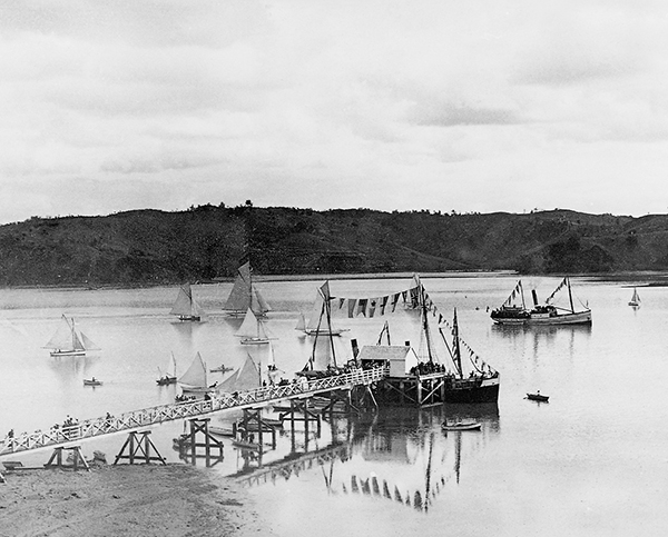
Hub of Maritime Mahurangi: Hosting the Mahurangi Regatta in style was already a proud tradition long before Ridge Road was formed and its last kilometre of narrow, unsealed—and during holiday weekends and the Mahurangi Regatta, dangerous to walk down—or there were automobiles to congest it, Scotts Landing was the beating heart of the Mahurangi. Mahurangi Regatta, 1901. photographer Henry Winkelmann
Laudably, since its 1972 acquisition as regional parkland, policy makers have resisted repeated appeals to make over part of the property to private-light-vehicle parking. Locals and visitors alike have tended to see the provision of parking on the eight-hectare property as entirely reasonable, but fortunately only a fraction of the one hectare of level land there is ever condoned, and then only temporarily, for that purpose.
While the policy of preserving the Scott Homestead environs essentially private-light-vehicle-free was sound, regional-park policy there has never been adequate to address the congestion the regional parkland substantively contributes to, despite there always having been entirely obvious solutions—particularly once Rodney District Council addressed Scotts Landing’s longstanding lack of a halfway-adequate wharf, under the connectivity-by-the-sea leadership of Mayor John Law. Law also readily backed, and his council built, Mahurangi Action’s concept for recreating the historic foreshore path
between the landing and Scott Homestead, in time for the Mahurangi Regatta Ball
celebrating Warkworth’s 150th, in 2004.
Scott Homestead by bus or by boat Until 2003, the grounds of Scott Homestead had been becoming increasingly popular, as a marquee wedding venue. The 1800s ambiance of the homestead and its setting, unsurprisingly, was a significant part of its appeal as the venue for traditional weddings. Complaints about the contribution of weddings to the already very congested road to the landing, and to the landing itself, led to a policy change—a pun-inviting, virtual wedding ban. The blindingly obvious alternative to the draconian limitation imposed on numbers, of 35, which patently does not allow for most traditional weddings, was simply to stipulate that guests must arrive and depart by other-than private light vehicle—by bus, being the readily available alternative, and by ferry less so, but far from impracticable and infinitely more romantic.
Clearly, by-bus-or-by-boatbbobb, not! would not suit every intending wedding couple, but neither does it need to. Given that wedding or similar use would be restricted to a limited maximum number of days per year—with weekend days particularly circumscribed—the venue would be the preserve of those for whom the Scott Homestead setting still had overwhelming appeal, for their marquee-style wedding or other significant event.
As with Te Muri, Scott Homestead, aside from needing and deserving to be better used, is key to encouraging other-than private-light-vehicle regional park access. While the long-term future, indubitably, is for regular public transport services to regional parks, Te Muri Beach and Scott Homestead are examples of the just about the juiciest, low-hanging fruit imaginable, and for which existing demand is, or has been, already powerfully demonstrated. Nor, surely, can self-funding be ignored. The Mahurangi West community, learning from Scott Homestead demonstration of demand, applied the model to its cherished but income-challenged, diminutive, pretty-as-a-picture former single-room-schoolhouse Mahurangi West Hall. From just a limited marquee season, income from the marquee site created provides the bulk of the funding needed to keep the venue in excellent repair.
Case for civilised Scott Homestead facilities Mahurangi West can potentially repay the compliment provided by the former Scott Homestead self-funding marquee site operation. Rather than require every user of the Mahurangi West Hall marquee site to supply portable toilets, which few enjoy using, the community designed and built a detached facility, in the style of the former schoolhouse, with about the best views in the west. The civilising effect of unexpectedly decent toilets deserves a slew of research studies, but in their absence, the anecdotal evidence from Mahurangi West is persuasive, the addition of cut flowers is not unheard of. Meantime, requiring picnickers or beach users to walk more than 200 metres to public toilets on the landing that can be heavily used just bytypo, be, picked up by subeditor, but editor subsequently failed to implement visitors to that busy location with its elevated level of vehicle movements and manoeuvring, is unsafe, and not infrequently unsanitary.
Case for Scott Homestead to be open daily Mahurangi Action’s 47-year relationship with Scott Homestead—most of its general meetings having been held there—and particularly its intensive use of the facility on Mahurangi Regatta – Auckland Anniversary weekends, leaves the organisation acutely aware of the intense curiosity of visitors to the bay, in the interior of the historic homestead. The notion that book-a-bach is an appropriate use of Scott Homestead is impoverished. Occupied thus, as the private domain of its privileged occupants, this building with its noble history of hospitality would become hospitality’s very antithesis.
Superficially, the book-a-bach model is entirely, appropriately egalitarian. In practice, however, only an infinitesimal percentage of the regional parks’ six million visitors per year get to stay overnight in a regional park bach. Additionally, those successful in booking baches during holidays and holiday weekends are largely confined to those who have mastered the art of contriving to be at the head the queue, the second, six months out from the opening of the particular month’s bookings, that bookings open. Be that as it may, a facility that dominates a park, as Scott Homestead does, should not be off limits to the bulk of that park’s users. Instead, operated along the lines of Leura’s volunteer-run Everglade Gardens, equity of access would be ensured, daily, while restoring the community’s natural, genteel hub.
Specifically Include policy to investigate how the Scotts Landing regional parkland and Scott Homestead might be developed, long term, so as to mitigate the private-light-vehicle congestion that currently besets the locality. Particular attention must be given to uses that lead to the
homestead be open to visitors, daily.
13 Mahurangi Regatta measure of regional-park equity of access
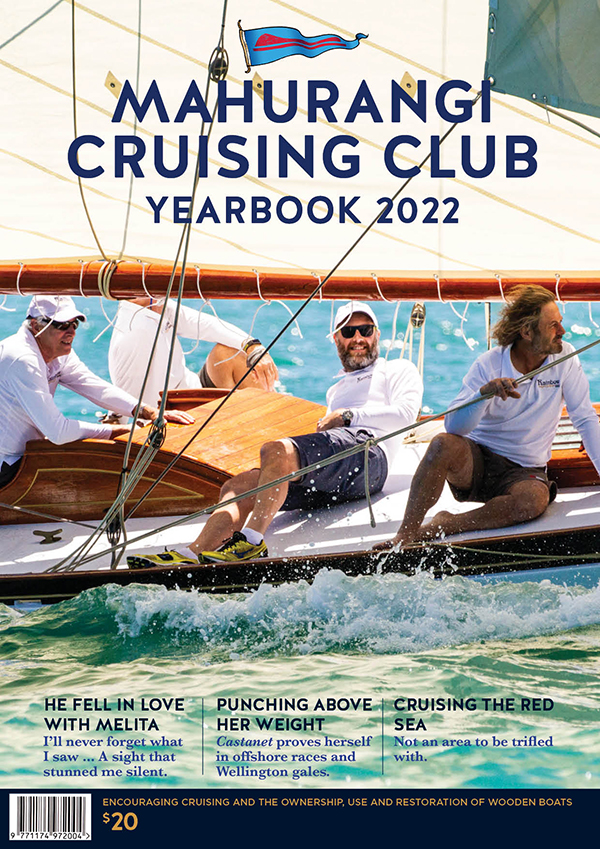
Ten-Week Yearbook Notification of Cancellation of Regatta Shoreside Events: With fit-for-purpose border management and isolation facilities, a good old-fashioned, leave-your-wallet-at-home Mahurangi picnic regatta might have safely been planned for 2022. The lavish classic yacht sailing was still able to occur, on 29 January, but the neither the beach events at Sullivans Bay, nor the jazz-orchestra-fueled prize-giving dance can safely be held. In 2021—as so sublimely conveyed by the cover of the subsequent yearbook—the risk was deemed low. Ten weeks out from the event, the combination of significant community spread, less than comprehensive vaccination, and the vastly more transmissible variant, Omicron reported the day before, unambiguously precluded massed gatherings where access could not plausibly be restricted to the vaccinated and traceable, and, in a less dysfunctional world, tested.
publication Mahurangi Cruising Club
Mahurangi Action, as Friends of the Mahurangi, revived the Mahurangi Regatta in 1977. Lapsing during World War II, the Mahurangi Regatta was first recorded in 1858, but was evidently well-established by then. Access to Sullivans Bay – Ōtarawao to host the 1977 revival was readily received, despite the regional parkland not then being open to the public.
Mahurangi and its city As attested by newspapers as early as 1865, the Mahurangi Regatta was always a coming together of the owners and crews of local working boats, and of yachts—predominantly of Mahurangi and Auckland city, respectively. Once opened as Mahurangi Regional Park, mindful that many who attended would be unaware a regatta was in progress, the organisers strove to include those people in the event—the children, and their enthusiastic parents and, famously, grandparents, took little coaxing to particate in the perennially popular beach races, including sack, three-legged, egg-and-spoon, and so on. Dinghy races were a main feature, involving many heats and many competing in dinghies spontaneously loaned.
The reviving committeewhich included the principal author of this submission, then, at 30, the baby of the committee, most of whom having witnessed the Great Depression, determined that the event should be good old-fashioned, leave-your-wallet-at-home picnic regatta, with no food and fairground wares to make it a costly experience for young families. Those caring people would no doubt be appalled to witness the degree to which societal inequity has developed since and which the covid-19 pandemic has so cruelly deepened.
Since its low-key 1970s-revival days when sailing craft of every description competed, the Mahurangi Regatta has famously become a nationally significant, internationally renowned, classic wooden yacht spectacle, backdropped, perfectly, by coastal regional parkland. Its more recently revived after-match prize-giving dance held in the regional park at Scotts Landing, with Scott Homestead providing 1800s ambience, slightly updated by a 20-piece swing-era jazz orchestra, is Tāmaki Makaurau at its civilised and egalitarian best—the leave-your-wallet-at-home regatta revival ethos, although calling for fiscal creativity, has survived. The proximate challenge, however, is coping with the 5000 people and 1000 boats and growing, drawn to the Mahurangi Regatta, despite the better-not-bigger mantra of overall regatta organiser, Mahurangi Action, and its principal sponsor Teak Construction.
If Auckland Anniversary weekend is not the highest visitor three-day period for the Tāmaki Makaurau regional parks network, it certainly is for the greater Mahurangi regional park. Since the end of the 2021 covid-19 lockdown, Sullivans Bay – Ōtarawao is seeing unprecedented visitor numbers by road and, conspicuously, by sea. This year, the regatta shoreside events were cancelled more than nine weeks in advance in anticipation that community spread would, by Auckland Anniversary weekend, make it entirely irresponsible to encourage large numbers of untraceable individuals to heavily exercise in close quarters, be it to run races at Sullivans Bayknown more recently as Sullivans Bay by mana whenua but before that as Jacksons Bay, and, prior to settler influence, as Ōtarawao or dance until midnight at Scotts Landing.
Setting aside the pandemic boost to patronage, the Mahurangi Regatta provides a useful ongoing measure of regional-park equity of access. With Sullivans Bay – Ōtarawao long since overcapacity on regatta day, by its default, private-light-vehicle mode of access, a raft of measures demand exploration and trial:
Regatta access via Mahurangi Coastal Path Once the Mahurangi Coastal Path is in use, end-to-end, equitable access will be available via public transport from Waiwera, and potentially closer. After an hour and 20 minutes on foot from the bus stop at Waiwera, through coastal regional parkland to die for, regatta goers would be rewarded with grandstand views of the sailing. Currently those driving to Sullivans Bay – Ōtarawao are typically spending as much time as that or more crawling or stationary in motorway traffic. As is the case with Wenderholm and Te Muri, the beach at Ōtarawao is the primary appeal, it and the adjacent coastal terrace attracting the overwhelming percentage of vehicle and foot traffic, and space occupied for playing, picnicking, and lounging generally. Amenities, such as toilets and water taps, consequently, are also concentrated, close to the beach. Arrivals on foot, whether they be from Waiwera, or from the camping grounds at Wenderholm or Te Muri, should be able to avail themselves of a toilet or a drinking fountain near the Ōtarawao Saddle, and if a regatta spectator, proceed from there to their vantage spot of choice, without unnecessarily adding to the beachside congestion. There is every likelihood that regatta spectators arriving via the coastal trail will schedule their swimming opportunities for Te Muri, Wenderholm, or even at the Waiwera mineral pools, rather than contribute to the beach congestion at Sullivans Bay that day.
Regatta Day cross-harbour ferry Many of the private-light-vehicle movements generated by the Mahurangi Regatta are in response to the need for regatta goers to travel between the regatta’s two regional park venues: Ōtarawao and Scotts Landing. The solution is not that which is often imagined, which would be for Sullivans Bay – Ōtarawao to also host the regatta after-match function. In the strong easterly conditions forecast for the 2022 regatta, for example, coming ashore from, or returning to, a vessel anchored on a lee shore can be hazardous at the Mahurangi Harbour’s most dynamic beach—even more so if the vessel is anchored on the weather shore and its tender navigates the width of the harbour, particularly after dark, few tenders having proper navigation lights. Otherwise, making the prize-giving-and-dance venue dependent on the forecast wind direction or strength, when hosting several thousand regatta-goers is too great a logistical challenge, for both organisers and attendees.
Arguably of at least as great importance is the desirability of the communities on opposite sides of the Mahurangi being able to readily participate in the harbour’s sole, shared, traditional, annual community event. The long-mooted cross-harbour ferry service, when finally realised, will have its busiest day on that of the Mahurangi Regatta. On the other 364 days of the year, of course, the cross-harbour ferry will service regional-park users. Provided that the service evolves from its Mahurangi Coastal Path connection to Waiwera, and that it is implemented with measures to prioritise other-than private-light-vehicle access to Scotts Landing and the regional parkland there, a cross-harbour ferry service will be a critical component in reducing the congestion to the historical hub of the Mahurangi Harbour.
Mahurangi Regatta jamboree A key component in reducing private-light-vehicle congestion at the Mahurangi Regatta, and at other times, is to spread the arrival time of regional-park users. Holding a veritable Mahurangi Regatta jamboree at Te Muri would place those campers a mere eight minutes from the best regatta viewing vantages. Assuming that the 3.4-hectare historic Nokenoke Block was the jamboree campsite, a thousand campers could be accommodated there, whilst observing fire regulations. Provided that strong easterly winds were not forecast, the Nokenoke would also be imminently handy for regatta small-craft competitors, particularly for competing kayakers.
Short of the suggested annual at-scale regatta camp, as detailed in the Te Muri Regional Park section,Te Muri generally is perfectly suited to a major expansion of its remote camping opportunities.
Regatta lessons from Scotts Landing Since Mahurangi Action’s 2004 revival of the Mahurangi Regatta Prize-Giving Dance, that organisation has learned that regatta goers and Scotts Landing locals alike are responsive to, and deeply appreciative of, other-than private-light-vehicle access to the after-match venue—a marquee beside Scott Homestead.
Until 2021, the service took the form of a single 11-seater shuttle bus, operating the final two, footpathless kilometres of Ridge Road. Not only did the free regatta shuttlebus greatly reduce the number of private light vehicles attempting to park at or near the landing, it had the immediate effect of convincing locals that the regatta organisers appreciated the private-light-vehicle congestion they endure throughout the summer, not to mention the dust and danger of the last kilometre.
In 2021, a second vehicle—a 22-seater—and paid driver was deployed, and a managed access plan implemented, at considerable cost, to supplement the, by then standard, 11-seater and the free paddock parking regime. Aside from concern verging on outrage at the fiscal cost to the regatta of implementing the managed access plan, it was realised that three 11-seaters would have provided a far more frequent service—always one awaiting patrons at either end of the run, and one underway. Further, it was found the lengthier, 22-seater took much longer to reverse direction, at the paddock-parking end—it lacking a carriage sweep.
As discussed in the previous section, the most conspicuous opportunity for reducing road traffic to Scotts Landing is to revive the landing’s traditional function as a maritime transport hub. When it was previously that, Ridge Road was unformed. Locals typically rowed to the wharf there, until the tide turned on the steamboat era with the belated advent of all-weather roads, in the 1930s. The sanity prevailing on regatta daybut not in 2022, when the shoreside events were cancelled nine weeks in advance, in anticipation of significant CoViD-19 community spread, and the absence of the option of restricting access to the bearers of vaccination passes, when virtually the only road traffic is public, and walkers can board wherever they encounter a shuttle, is a vision for a reimagined Scotts Landing for, in the fullness of time, the other 364 days of the year.
Specifically the draft planAuckland Council’s draft Regional Parks Management Plan, issued for public consultation 10 December 2021 should cite the Mahurangi Regatta as a potential case study of how the Scotts Landing regional parkland, and access to it, could be trialled as a walkable locality.
14 Four’s three too many – One great Mahurangi regional park
While it might not be the most important consideration, treating the contiguousconsidering intervening rivers, streams, and the Mahurangi Harbour to be connecting rather than dividing900-hectarenot including Scandrett actual regional parkland or Scotts Landing Department of Conservation, pseudo regional parkland, 883 hectares, 25-kilometre regional parkland coastline as four separate parks makes for an extremely unwieldy policy-making process when it comes to the Mahurangi Coastal Path, planned to connect it all. The far more fundamental concern is that the societal and conservational wealth of a 900-hectarenot including Scandrett actual regional parkland or Scotts Landing Department of Conservation, pseudo regional parkland, 883 hectares regional park is not readily communicated to park users. Visitors who enter the greater Mahurangi regional park at the Waiwera River deserve to know, immediately, that they are stepping into a park that extends 900not including Scandrett actual regional parkland or Scotts Landing Department of Conservation, pseudo regional parkland, 883 hectares hectares and 8.4 kilometres north-northeastward.
Mahurangi Action, in its Mahurangi Coastal Path Trust-endorsed submission on the draft management plan variation in respect to Te Muri, included an 800-word section imploring:
…the rigorous consideration of the implications of rationalising Mahurangi, Te Muri and Wenderholm regional parkland as one, Mahurangi Regional Park.
In response, the commissioners said they agreed with the Auckland Council officer-note:
The question of the recognition of agglomerations of regional parks is better addressed in the context of the pending review of the rpmp 2010Auckland Council’s 2010 Regional Parks Management Plan as a whole.
Notwithstanding that note, there is no mention in the draft planAuckland Council’s draft Regional Parks Management Plan, issued for public consultation 10 December 2021 of the Mahurangi, Te Muri, and Wenderholm regional parkland amalgamation advocated. Otherwise, whether the unification of a landscape as visually and ecologically contiguous as the Mahurangi coastline can legitimately be characterised as an agglomeration is moot—arguably best commented on by coastal landscape architects, coastal ecologists, coastal geomorphologists, and even coastal engineers.
Specifically the draft planAuckland Council’s draft Regional Parks Management Plan, issued for public consultation 10 December 2021 should include policy to investigate the amalgamation of the greater Mahurangi regional parkland.
15 Responding to climate change – the “beyond-urgent” imperative
As required by both the Climate Change Response (Zero Carbon) Amendment Act 2019 and Te Tāruke-ā-Tāwhiri – Auckland’s Climate Plan, the draft planAuckland Council’s draft Regional Parks Management Plan, issued for public consultation 10 December 2021 does respond to the climate emergency, but not convincingly nor consistently, nor is the climate response policy consistent with other of the plan’s responsibilities, such as equitable access. The prime example concerning this submission is the proposal to upgrade Hungry Creek Road access to Te Muri Regional Park for private-light-vehicle access. This perverse proposed policy is addressed in detail in the previous sections pertaining to Te Muri Regional Park and to the Mahurangi Coastal Path, to address the draft plan’sAuckland Council’s draft Regional Parks Management Plan, issued for public consultation 10 December 2021 statement:
Broadening travel alternatives will also help improve equity of access and help relieve parking congestion at popular parks.
The summary of feedback received in the first phase of consultation reported that the five issues the largest numbers of submitters felt strongly about included:
responding to climate change – the “beyond-urgent” problem
The beyond-urgent compound adjective is from Mahurangi Action’s feedback, quoted in section 2.3 of the summary – Diversify Access to Reduce Visitor Vehicle Emissions:
The direction of park development needs to be in support of the beyond-urgent climate crisis. There is now a clear need for visitors to be able to travel light (without their cars) and to purchase refreshments and accommodation within the parks.
The quoted passage is an amalgam summarising a paragraph of Mahurangi Action’s feedback text. The feedback, with a careless lacuna kindly addressed, read:
Regarding the discussion-paper questions as to whether new directions should be developed for the regional parks and more offered, from leisure to accommodation. Again, the imperative to do this is the beyond-urgent need for climate-action mobilisation. When the Tāmaki Makaurauomitted in feedback submitted by Mahurangi Actionregional parksomitted in feedback submitted by Mahurangi Actionnetwork was conceived,omitted in feedback submitted by Mahurangi Action the unquestioned model was car-owning families visiting the parks complete with considerable picnic, or indeed camping, paraphernalia. Now,new sentence begun, reversing the “, there is now…”, as “. Now, there is…” there is a clear need for visitors to be able to travel light, and purchase refreshments and accommodation within the regional parks.
In all probability, this proposed policy shift will be abhorrent to the majority of longtime regional park visitors. However, the climate emergency demands that, in the familiar balance between democratic leadership and the unearned political rewards of pandering to the status quo, climate action, increasingly, must be favoured. With access to Te Muri Beach the reward for a 25-minute, highly scenic walk, regional park visitors will vote, emphatically, with their feet. Provided that the services needed by visitors arriving other-than by private light vehicle are stringently unobtrusive, those sensitive to changes from the original car-centric ethos should soon acclimatise and learn to love regional parkland not visually impacted by vistas of massed parked vehicles.
Specifically Include joined-up policy to support the twin imperatives of equity of access and the climate emergency, channellingsubmitted sans an L the intrinsic appeal of a significant regional parkland coastal trail, and the very considerable appeal of Te Muri Beach.
16 Sea-level rise and farewell to regional-park spit beaches
Last time that global temperatures were those of today, the paleoclimate record reveals than sea levels were 6–9-metres higher. That multi-metre sea-level rise is now locked in is poorly appreciated generally, and seldom admitted to by policy makers. The reticence to acknowledge this reality is understandable, and behavioural psychologists worry that the public will lose the incentive the act, if confronted by the brutal long-term reality.
Climate scientists, rather than behavioural psychologists, should be the more profound influence on policy makers. The almost unspeakable ephemerality of beaches, the Mahurangi Magazine contends, also has the power, potentially, to rally and to motivate. Responsible and compassionate leadership demands that the labour of building better resilience, through the establishment, for example, of indigenous sand-binding plants, is recognised as useful short-to-medium term, both ecologically and psychologically, without indulging in denialism about the eventual total loss of most east-coast regional park beaches, within generations.
Young people, in particular, deserve to be able to learn about sea-level rise and participate in honest, constructive, meaningful responses to it, in their regional parks.
Specifically regional park policy should strive to not contribute to the cognitive dissonance experienced by the users of coastal regional parks aware of the particular impact on those parks of sea-level rise. Regional park policy should be to transparently mount a robust, apposite and,
above all, honest response.
17 Equity of zero-carbon regional-park access – Gluckman’s gauntlet
Gluckman’s Gauntlet: At his second successive appearance as Mahurangi Coastal Path-fundraiser guest of honour, Distinguished Professor Sir Peter Gluckman deftly worked his talk outlining the magnitude of the epidemiological, public health, educational, and economic long-term impacts of covid-19, back to equity of access, challenge to the trail trust to ensure that young people used the coastal trail.photographer Maree Owston-Doyle
To deliver on the twin imperatives of equity of access and zero-carbon access, the regional parks management plan must communicate to Auckland Transport the specifics of what it expects from that council-controlled organisation. Having said that, it must be acknowledged that—in response to the climate emergency and the social equity crisis— the private-light-vehicle-accessed-model on which the regional parks network of Tāmaki Makaurau is based, is now required to be rigorously interrogated. Only by committing to render regional parks more accommodating of visitors travelling light, by public transport, can Auckland Transport be asked to respond commensurately.
Fourth-tier targeted services Regardless of what measures are embraced by Auckland Transport, for example the much-needed inclusion of Pūhoi in the transit network, fourth-tier targeted services are an entirely indispensable component.
Fourth-tier targeted services are the lowest, typically slowest, component of rapid transit networktypically rendered to the three-letter-acronym: RTN, the first tier of which consists of rail and bus ways. The second tier comprises high-frequency bus services, utilising bus lanes and traffic signal pre-emption. The third tier comprises connector and local bus and ferry services. The key word and concept is network. Without the lowly fourth tier providing crucial connectivity, the vicious cycle of private-light-vehicle dependency cannot be broken, with profound consequences for both equity of access and climate. A family, for example, cannot currently contemplate spending a day at a regional park beach, without it being a crushingly near-insurmountable logistical challenge.
Fourth-tier targeting Waiwera, Wenderholm, and Pūhoi At first blush, inclusion of Pūhoi in the Hibiscus Coast Station – WarkworthRoute 995 express route was entirely to be expected. However, given that the decision was taken that a concurrently built motorway-side bus stop at Pūhoi would be prohibitively costly, even if Pūhoi was eventually provided a third-tier service, the town would benefit immensely from being included in a fourth-tier service linking Waiwera, Wenderholm, and Pūhoi. Initially, patronage of such a service would be driven, by the irresistible charms of Te Muri Beach, accessed via Waiwera’s longstanding transit connection. Concurrently, however, Waiwera – Pūhoi patronage would develop, not least of all for from Wenderholm–Te Muri–Pūhoi loop trail demand, but also, of course for the patent reason that Pūhoi has, for so egregiously long, lacked public transport.
Fourth-tier targeting the Mahurangi Peninsula With the doubling in size of the landlocked 93 hectares of regional parkland on the Mahurangi Peninsula, with the help of the John Turnbull and Margaret Turnbull trusts, Auckland Council promptly billed the acquisition:
Although the OurAuckland article is careful to note that how the parkland might provide unrivalled access was subject to regional parks management plan processes, nor was there any hint that the increased harbour access might be other-than by private light vehicle. Two years on, this indication is confirmed in the draft planAuckland Council’s draft Regional Parks Management Plan, issued for public consultation 10 December 2021 with reference to establishing car parkingclearly meaning: private-light-vehicle parking and enabling vehicle access into the park. As with Te Muri, the assumption that access to new regional parkland must be by the same-old-same-old private-light-vehicle model, must be robustly challenged. Although the option should not be ruled out, excluding private light vehicles from regional parks that have long accommodated them would be one thing. However—when the default regional-park access model must so patently be retired, in response to the climate emergency and the equity-of-access imperative—delaying the opening of new regional parkland indefinitely on account of the “considerable infrastructural investment” involved in private-light-vehicle access is as unnecessary as it is unsound, and is patently inconsistent.
Gluckman’s gauntlet Shamelessly exploiting the the local Liggins connection, the
Mahurangi Coastal Path Trust prevailed upon Distinguished Professor Sir Peter Gluckman to be its speaker at a charity fundraiser, which he readily agreed to, twice. At the second event, at the conclusion of his hard-hitting address, and otherwise aware of the trust’s commitment to low-carbon regional-park access, Sir Peter issued a blunt challenge:
While proponents of the planned Mahurangi Coastal Path could take the position that, because equity of access to the regional parks network of Tāmaki Makaurau is a systemic obligation and responsibility, they—the coastal-trail builders—can remain essentially agnostic as to the age-groups of coastal-trail users. On the contrary, it is the mutual responsibility of the coastal-trail stakeholders, and to the mutual long-term benefit of the coastal-trail stakeholders, to address equity of access strategically, and in concert.
While the Mahurangi Coastal Path cannot be expected to shoulder the burden of addressing half a century of inequitable regional-park access singlehandedly, it can, by ensuring that coastal-trail users, arriving by other-than private light vehicle, feel they are respected and advantaged visitors. Picture the scenario where a group of young people none of which is old enough to hold a full driver licence, arrives at stop 4793, Waiwera. The boisterous consensus is that, rather use the regional-park shuttle, the group will “race you” the two kilometres “to the ferry”. One of a pair seated together to that point suggests, to a pair who appear to be less aware of the logistics of public transport:
Go on you two, but give us that mountain of gear you’re carrying—we want to talk anyway.
In this scenario, one the pair riding in style to Wenderholm Jetty had earlier confided his reason for, uncharacteristically, not being the first to want to run, that day.
The logic of the 39-year-old Mahurangi Coastal Path concept has always been how magically close Waiwera is to the Mahurangi Harbour, via the coastline, in blissful contrast to the 17-kilometre journey by road, punctuated by its typically dusty and deeply pot holed culmination. Waiwera has had a long proud history of public transport, both by steamboat and coach trail. Until the advent of regionally planned public transport, in the late-20th century, bus services to the town were minimal. Since that time, the compelling logic of the planned Mahurangi Coastal Path has been equity of access and, increasingly, equity of zero-carbon access, via an hourly service to the metropolitan gateway—Waiwera—of 900not including Scandrett actual regional parkland or Scotts Landing Department of Conservation, pseudo regional parkland, 883 hectares hectares of regional parkland. This, indubitably, is the epitome of low-carbon, equitably accessible low-hanging fruit—and the juiciest.
Mahurangi Magazine submits that policy should be further developed to specifically provide for the planned Mahurangi Coastal Path, with its robust, established stakeholder and treaty partnership support, to showcase a step change in low-carbon regional-park equity of access.
Anthropogenic global warming is described as a wicked problem for profoundly sound reasons. Key amongst those reasons is that the extent that fossil fuels underpin civilisation in the 21st century is poorly understood. So poorly understood, in fact, that energy polymath extraordinaire Distinguished Professor Emeritus Vaclav Smilapproximately: vahts-lahf smeel—known, “ruefully”, as “Bill Gates’ scientist”—has published, as of 27 January, the imminently readable title How the World Really Works, in rigorous determination to disabuse decision makers, and those who choose or tolerate them, of their wilful readiness to underestimate the enormityprimarily, in the greatness of size, scope, extent sense of the word, but also, because of its inequitable impact, in the word’s dominant sense of heinousness of the challenge of slashing fossil-fuel use.
During the 50 years that Tāmaki Makaurau gained its magnificent, 41 000-hectare regional parks network, its population trebled. At its recent rate of growth, during its next 50 years, a further trebling is entirely possible. The creation of the regional parks cannot be allowed to be regarded as job done. But nor is the old borrow-and-purchase approach to acquiring further regional parkland likely to be reintroduced, at scale. More sophisticated means will need to be deployed, such as the self-funding park model pioneered, at least in Aotearoa, by Sir John Logan Campbell, with Cornwall Park.
While the regional parks management plan process is probably not regarded as the principal place to explore regional park acquisition policy, it would be most helpful if it was considered in parallel. This simultaneous consideration is desirable including because the acquisition of adjacent land can, in places, be key to resolving multiple challenges, not least of all for addressing equity of access. Where this can be achieved whilst introducing a significant self-funding element, its consideration as part of the regional parks management plan process is surely advantageous, however it might be accommodated.
Emphasis on accommodating growth, however, should not preclude interrogating assumptions about growth, both natural and immigration-fueled. How the regional parks network contributes to that discussion is not explored here, except to suggest as an extremely apposite and aspirational setting, in which it might take place.
Mahurangi Magazine submits that investigation should be undertaken as to how acquisition policy might constructively interface with the regional parks management plan process.
While the climate emergency is clearly the most compelling, indeed, existential imperative against which all actions must be assessed, the proximate Mahurangi Harbour crisis is its elevated sediment accumulation rate. Currently, the second of two major projects is underway to address sediment generation—a $5 million, government-funded project delivered by a partnership of Auckland Council and the Ngāti Manuhiri Settlement Trust. The big, Hauraki Gulf-scale picture is that the Mahurangi Harbour is taking one for the team, by acting as a 45-million-cubic-metre settling pond, into which an average of 21 000 tonnes of sediment pours, annually. Most of the sediment is generated in upper, hilly regions of the 22 200-hectare catchment. A tiny fraction is generated from the 883 hectares of regional parkland that makes up the greater Mahurangi regional park.
The Mahurangi catchment’s battle to address sediment generation illustrates the degree to which the dire health of the shallow, over-fished Hauraki Gulf is a challenge of epoch proportions. The notion that a new gulf administration replacing the current marine park forum have delegated powers to make regional park policy is risible. Any additional powers that might awarded as the result of a strengthened act need to be far more strategic than assuming governance of gulf-facing regional parkland. The Mahurangi Magazine strenuously registers its considered opposition to “formally” including regional parks “into” the Hauraki Gulf Marine Park—Item 45, Section 7—unless formal inclusion is specifically defined, in regard to governance and ownership, as no more or no less than the degree to which the entirety of the Hauraki Gulf watershed of territorial Auckland Council is formally part of the Hauraki Gulf Marine Park.
Unless the terms of reference of the proposed investigation into formal inclusion make it unambiguously apparent that the governance structure of the regional parks network of Tāmaki Makaurau would not be fragmented or subjugated by the unelected Hauraki Gulf Forum, or any entity replacing it, Item 45, Section 7 has the potential to consume a significant part the regional parks management plan review process, to the great detriment of the myriad important issues that will already struggle to be duly and fulsomely considered.
Meanwhile, the text Item 44 verges on the insipid:
Manage parks that contribute to the coastal area of the Gulf with consideration of the Hauraki Gulf Marine Park Act 2000 and collaborate with the Hauraki Gulf Forum
This innocuous draft policy could reasonably be strengthened. The regional parks should be veritable showcases of practicable policy and practises to mitigate sediment generation and nutrient pollution.
Specifically Item 45, Section 7 of the draft planAuckland Council’s draft Regional Parks Management Plan, issued for public consultation 10 December 2021 should be considerably expanded to reflect the assurances by Auckland Council on 11 February 2022 that there will be no change to the governance and ownership of the regional parks network of Tāmaki Makaurau. Item 44, Section 7, meantime, should be strengthened.
20 Summary of draft-planAuckland Council’s draft Regional Parks Management Plan, issued for public consultation 10 December 2021 submission specifics
The following list is numbered for the sections, not all of which carried specific policy submissions.
2
Mahurangi Coastal Path – Background
Include background information to provide the context for the planned Mahurangi Coastal Path, linking the first and last acquisitions of the regional governance era, and contributing to Auckland Council’s Pūhoi to Pākiri project.
3
Mahurangi Coastal Path – Connecting 900 hectares of regional parkland
Include policy to investigate how the planned Mahurangi Coastal Path can contribute substantively to Auckland Council’s climate emergency, sea-level rise, equity of access, and public-health policy imperatives, on a non-trivial scale.
5
Mahurangi Coastal Path – The route planned
Include policy to support the trialling, in the near term, of a Mahurangi Coastal Path, Mahurangi Island to Mullet Point—Waiwera to Algies Bay, to help gauge potential for regional park transit-access options.
6
Regional-park gateway to Te Araroa the national walkway
Include policy to investigate how best to realise the synergy suggested by the confluence of Te Araroa, the Mahurangi Coastal Path, and the 900-hectare greater Mahurangi regional park.
7
Seventeen-kilometre Wenderholm–Te Muri–Pūhoi loop trail
Include policy to investigate the potential of the 17-kilometre Wenderholm–Te Muri–Pūhoi loop trail proposed, to showcase zero-carbon regional-park equity of access.
8
Wenderholm Regional Park
Include policy supporting the trialling of an initial Waiwera to Te Muri
‘Phase 1’ Mahurangi Coastal Path, deploying the surplus-to-operations Mahurangi Regional Park landing barge, in community ownership.
9
Te Muri Regional Park
Include policy to investigate more profound ways of ensuring that the sense of splendid isolation that defines Te Muri is preserved, while providing equity of access and a proportionate response to the climate emergency.
10
Mahurangi Regional Park – West
Include policy to prioritise Ōtarawao for day use, create disperse facilities picnickable areas away from the immediate shoreside, and support the community-led provision of fourth-tier targeted services.
11
Mahurangi Regional Park – Mahurangi Peninsula
Include policy to investigate how the Mahurangi Peninsula regional parkland might be developed, long term, to maximise equity of access while preserving its essential quality of remoteness, and in the short term, cooperate in a community-led fourth-tier-targeted-service trial, as part of the trialling of a Waiwera to Algies Bay coastal trail.
12
Mahurangi Regional Park – Scotts Landing
Include policy to investigate how the Scotts Landing regional parkland and Scott Homestead might be developed, long term, so as to mitigate the private-light-vehicle congestion that currently besets the locality. Particular attention must be given to uses that lead to the homestead be open to visitors, daily.
13
Mahurangi Regatta measure of regional-park equity of access
The draft plan should cite the Mahurangi Regatta as a potential case study of how the Scotts Landing regional parkland, and access to it, could be trialled as a walkable locality.
Responding to climate change – the “beyond-urgent” imperative
Include joined-up policy to support the twin imperatives of equity of access and the climate emergency, channelling the intrinsic appeal of a significant regional parkland coastal trail, and the very considerable appeal of Te Muri Beach.
16
Sea-level rise and farewell to regional-park spit beaches
Regional park policy should strive to not contribute to the cognitive dissonance experienced by the users of coastal regional parks aware of the particular impact on those parks of sea-level rise. Regional park policy should be to transparently mount a robust, apposite and, above all, honest response.
17
Equity of zero-carbon regional-park access – Gluckman’s gauntlet
Policy should be further developed to specifically provide for the planned Mahurangi Coastal Path, with its robust, established stakeholder and treaty partnership support, to showcase a step change in low-carbon regional-park equity of access.
18
Regional-park response to population growth
Investigation should be undertaken as to how acquisition policy might developed in parallel with the regional parks management plan process.
19
Mahurangi and the Hauraki Gulf
Item 45, Section 7 of the draft plan should be considerably expanded to reflect the assurances by Auckland Council on 11 February 2022 that there will be no change to the governance and ownership of the regional parks network of Tāmaki Makaurau. Item 44, Section 7, meantime, should be strengthened.
Wenderholm Regional Park acquired – first acquired by then-new regional councilfrom 1963 to 1989 named Auckland Regional Authority, thereafter Auckland Regional Council. Subsumed by Auckland Council 2010
1973
Coastal margin of Te Muri acquired under Public Works Act
1974
Mahurangi Action established, as Friends of the Mahurangi Incorporated
1983
Geotechnical investigation for planned road bridge across Te Muri Estuary
1987
Suggestions for the Mahurangi West Regional Reserve to citizens advisory group – by Mahurangi West and Pukapuka Residents and Ratepayers Association
1987
Submission on draft park management plan, including walking access, as opposed to the proposed road from Mahurangi West.
1989
Auckland Regional Authority becomes Auckland Regional Council
2010
383-hectare Te Muri hinterland acquired—road access to beach announced
2010
Auckland Regional Council subsumed by new, regional Auckland Council
2014
Mahurangi Coastal Path Technical Document for Discussion – Mahurangi Action
2015
Phase-1 of Te Muri variation to regional parks management plan – 140 submitters
2015
Mahurangi Action and Friends of Regional Parks establish Mahurangi Coastal Path Trust
2016
Phase-1 of Te Muri variation – further 383 submissions. All but a handful of the 523 oppose private-light-vehicle access to Te Muri Beach
2016
Auckland Council resolves to not allow private-light-vehicle access to Te Muri Beach
2019
Auckland Council – Mahurangi Coastal Path Trust memorandum of understanding to develop Mahurangi Coastal Trail, commencing with Te Muri Crossing
2020
Davis Coastal Consultants retained by Mahurangi Coastal Path Trust to design and seek resource consent for Te Muri Crossing
2020
Phase-1 Regional Parks Management Plan Review submissions
2020
With Ngāti Manuhiri, identified preferred route for Te Muri Crossing
2021
30 May First public presentation of Te Muri Crossing design, tickets $80
2021
3 July Te Muri Crossing coffee-and-croissants drop-in day at Mahurangi West Hall. Consensus expressed for undesirability of opening the Mahurangi Coastal Trail, only accessible by vehicle via the Mahurangi West scenic ridge roads.
2021
9 July Mahurangi Coastal Path Trust resolves to develop a plan for an end-to-end coastal trail, predicated on an amphibious Pūhoi River crossing, pending the possible replacement with a footbridge, should patronage demand, stakeholder support materialise.
2021
Draft Regional Parks Management Plan released 10 December, with call for submissions until midnight, Friday 4 March 2022.
2021
Christmas Day – Mahurangi Magazine’s work-in-progress submission on the draft regional parks plan notified.
2022
21 February – advice received from Auckland Council that the surplus-to-operations 4.9-metre aluminium landing-barge built to service Mahurangi Peninsula was approved for purchase by the Mahurangi community. Mahurangi Action Incorporated has resolved to acquire the vessel to trial a Pūhoi Estuary ferry service, a Mahurangi Harbour crossing, and to facilitate Mahurangi Regatta operations.
2022
4 March – joint Mahurangi Action, Mahurangi Coastal Path Trust, and Mahurangi Magazine submission on Draft Regional Parks Management Plan lodged.
2022
5 May – invoice received from Auckland Council for surplus-to-operations landing barge, and paid on same day by Mahurangi Action.
2022
10 October – publication of Regional Parks Management Plan 2022 in searchable format.
2023
10 February – debut of J Barry Ferguson on 92nd birthday of namesake benefactor.
22 Conclusion – Nice quiet place long way from town
Knowas written by Arthur Rex Dugard ‘Rex’ ‘ARD’ Fairburn: I know… However, post the popularisation of the folk song that shares an identical line, as the opening line of its chorus, which disastrously messes with the meter of Fairburn’s Walking On My Feet where I’m going
Where I’ll lie down
Nice quiet place
Long way from town…
The yearning to leave the city, and escape to a remote part of the coastline is as strong today as when Rex ‘A.R.D.’ Fairburn wrote these words, in an earlier period of economic and societal stress. In just over an hour of leaving work or study in the central business district, on a Friday afternoon, a person could walk on their feettitle of the Rex ‘ARD’ Fairburn poem excerpted above is Walking On My Feet into Te Muri, their gear and supplies awaiting them. Or Lagoon Bay, in under two, with two hours of daylight remaining.
Viewed from seaward, the coastline 17 kilometrespublished punch-drunk as hectares, online and in the PDF submitted from Ōrewa to Mullet Point appears utterly uninhabited. Viewed from Whangaparāoa Peninsula, other than a sprinkling of tell-tale lights after dusk, the entire coastline from Ōrewa to the Tāwharanui Peninsula appears empty of habitation, adding to the allure of a major coastal trail.
With the community committed to pioneering a Waiwera to Waipū coastal trail, and the means of commencing that within its grasp, the more than 2000 hectares of regional parkland along that coast will, realistically, one day be walkable.
Thirty-five years after first formally being put to a regional parks management plan process, the first step, crossing the Pūhoi Estuary, will begin to be trialled, this year.
This submission was a 12-week labour of love for Te Muri, Mahurangi, and Planet a, published online as a work in progress from Christmas Day onward, in response to the Draft Regional Parks Management Plan. This online vesion was last updated on 12 March 2022, to more faithfully mirror the pdf of the Mahurangi Coastal Path Trust versionlast lodged of the three submitted, the Mahurangi Coastal Path Trust version, which contained a mea culpa for the lack of a more comprehensive executive summary, was, on 7 March, accepted as the version common to eachthe three entities lodged ahead of the midnight Friday 4 March 2022 deadline, and to publish incrementally, as a work in progress, a commissioner summary.
Disclosure The principal author of this submission to the Draft Regional Parks Management Plan is the secretary of both Mahurangi Action Incorporated and the Mahurangi Coastal Path Trust and the editor of the editorially independent, independently funded Mahurangi Magazine. This incrementally published submission, ultimately, is that of the three entities, which reserve the right to be heard separately.
Disclosure The editor of this content is no longer the
secretary of either the Mahurangi Action Incorporated or the
Mahurangi Coastal Path Trust. Regardless, that here continues
to be published by the editorially independent, independently
owned and funded Mahurangi Magazine.