Grand future for good-old-fashioned picnic regatta
author Cimino
published as a work in progress 20231108–
Exceptional Shoreside Regatta: Thanks to the forecast for a stiff northeasterly, the 2006 Mahurangi Regatta shoreside events were held at Scotts Landing, it being that or nothing. Nothing, in retrospect, would have been the sounder option. The dilemma was that, with the Auckland Regional Council picking up the bill for that year’s shoreside events—as part of its desire to launch its Mahurangi Action Plan at the harbour’s only at-scale annual community event, at Sullivans Bay—cancellation was … complicated.
photographer Max Cumming
Pointedly billed as a good old-fashioned, leave-your-wallet-at-home picnic regatta since its 1977 revival by Mahurangi ActionMahurangi Action Incorporated: established 1974 as Friends of the Mahurangi, the organisation has very determinedly kept it that way ever since.
Although the beach had been in public ownership for Mahurangi West parkland acquired 1967–1970seven or so years, when permission was first sought to hold the regatta from there, Sullivans BayŌtarawao. Also: (before Sullivans Bay) Jacksons Bay was yet to be opened to the public. Official blessing, nevertheless, was immediately forthcoming, and what was intended as a one-off, became an unequivocally annual affair.
From an inside-out, Mahurangi Regatta perspective, organisers could consider that, forever and a day, the traditional shoreside events must be held at Sullivans Bay, on regatta day—the Saturday of Auckland Anniversary weekend. Except, perhaps for the inconvenient fact that the contemporary timing of the regatta only dates from 1979—more than 121 years after the event was first noted.
Until the 2010s, the traditional shoreside events rubbed along with non-regatta-attracted regional park visitors famously inclusively. That oft-expressed sentiment was formally recorded in 2016, during an Auckland Council survey of visitors:
Didn’t know the event was on but it was a pleasant and enjoyable environment.
Ominously, the same survey heard indications that the park, on regatta day, was nearing or exceeding capacity for private-light-vehicle parking, and tolerance for other impacts:
We had a lovely day apart from the dreaded loudspeaker, the car parking was at a premium, which I guess is a good thing as so many people were enjoying our beautiful parks.
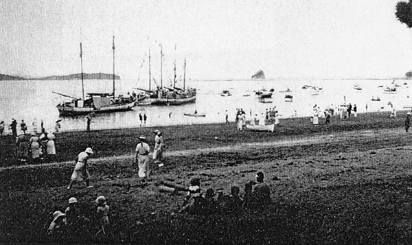
Addressing its Autopian Beginnings: Auckland’s regional parks were conceived as part of a determinedly autopian vision for Auckland. The climate emergency, much less the dire need to address extreme inequity, calls for regional parks to be made readily accessible by other than private light vehicles. Pictured, Sullivans BayŌtarawao. Also: (before Sullivans Bay) Jacksons Bay, during a 1930s Mahurangi Regatta, when, not only were all-weather roads were only just reaching the Mahurangi Harbour community, it was decades before Ngārewa Drive—the road to Sullivans Bay—existed.
image Jade River: A History of the Mahurangi
Although the survey, which was also conducted in 2015, indicated an overall satisfaction score of 95%, it was clear that, despite the organiser’s better-not-bigger approach, the Mahurangi Regatta:
- would continue its steady, inexorable growth, and
- a better regatta would likely grow even faster.
Consequently, Mahurangi Action began exploring concepts for responding to regatta growth pressure. The then best current thinking was successfully submitted to the 2022–2032 regional parks management plan, including a coastal path whereby Te Muri and Sullivans Bay could be more equitably accessed generally, but, importantly during peak periods, and particularly during the Mahurangi Regatta.
The obvious equitable-access solution, as emphasised in the joint Mahurangi submission, is the long-planned Mahurangi Coastal Path. Metropolitan regatta-goers, after a relaxed, scenic, coastal trolleybusdiesel-powered buses initially, but grid-powered—in-motion-charging trolleybuses—with every ounce of climate-emergency urgency trip, and a startlingly short walk, would find themselves spoilt for choice for picnic spots with panoramic views of one of the world’s grandest displays of massed classic yachts, under sail. But to really live like kings, regatta goers would have couriered their camping boxes ahead, to Waiwera, Wenderholm, Te Muri, Sullivans Bay, Mita, or even to Lagoon Bay, and would spend at least three sublime evenings under the stars.
Since the first battle was won to preserve the sense of splendid isolation palpable at private-light-vehicle-free Te Muri, the requisite infrastructure has repeatedly found itself in the bureaucratic too-hard basket. The first excuse, in 1987, was that there was no budget for a low-key boardwalk and footbridge across the upper Te Muri Estuary—whereas there had been, for geotechnical work for the road bridge planned smack across the estuary’s most visually sensitive body. In 2016, treaty-partner reticence suspended tacit Auckland Council support for a planned Judge Arnold Turner Footbridge, across the Wenderholm Estuary, replacing it with a council-initiated plan to cross Te Muri Estuary, instead. Eventually, however, the illogic of accessing Te Muri primarily from other than the south, caught up with the project, and that too was canned by the council.
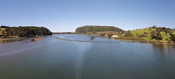
Grand Buoyant Future for Pūhoi Estuary Crossing: With the new regional parks management plan parking up the planned Te Muri Crossing, it is timely to revisit earlier resistance to starting the Mahurangi Coastal Path at the logical, already public-transport-connected southern end. Since this 2016 concept, testimony to sea-level rise in the pipeline demands that, in addition to conventional pier-supported footbridge construction, buoyant options be evaluated.
rendering Littoralis Landscape Architecturedrone image Majorlook Productions
Given the magnificence of connecting the 1000 coastal hectares from Waiwera to Purahurawai,Scandretts Bay, Scandrett Regional Park the protracted mission, ultimately, will be more than vindicated. Mahurangi Action and the Mahurangi Coastal Path Trust are now committed to an end-to-end Mahurangi Coastal Path. Having said that, it is possibly strategic to open the first crossing—the by that or any other nameJudge Arnold Turner Footbridge, across the Pūhoi Estuary—in advance of the section that includes Sullivans Bay. By so doing, regional-park visitors—the vast majority of who have yet to discover Te Muri—would become habituated to accessing Te Muri Regional Park from the south—healthily, on foot. Mahurangi West and the planet would be spared considerable, avoidable, extra 30-kilometre-return private-light-vehicle movements.
Arguably, rather than exacerbate Sullivans Bay congestion, Mahurangi Action should consider a shoreside-events hiatus, in the reasonable anticipation of equitable-access-policy implementation, and the further freeing up of prime regional-park picnicking estate.
But rather than an arbitrary curtailment of the mostly massively popular shoreside events, the plan now is to proceed with a simplified, lower key, lower cost programme:
- No public address system, except possibly a bullhorn
- Simplify, simplify
- Run only events that children have presented for, particularly in the morning
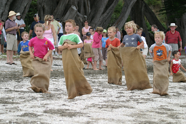
- Short running races—including three-legged, sack, etc.—in the afternoon
- Low-key sand sculpture, with teams choosing their own sites
- Every entrant a certificate, everyone welcome.
So, let the events held be dictated by the enthusiasm of the entrants, and the number and energy of the 2024 shoreside-regatta crew muster, gauged by the customary Mahurangi West Hall pre-regatta meeting: 7 pm Monday 22 January, Mahurangi West Hall.
Public transport footnotes Below are footnotes of crucial significance to the parent article, given the beyond-urgent imperative for climate-action mobilisation, and the pivotal role of public transport:
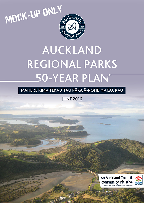
Mocking-Up Failed to Get Auckland Council Moving: The 50-year anniversary of Auckland Regional Parks, most might have agreed, was the perfect opportunity to begin exploring how the region’s network of coastal parks could begin to be reimagined, beyond the automobile age. Conceived amidst the misguided 1950s machinations that committed New Zealand’s metropolis to terminal autopian congestion, seriously joined-up thinking is now necessary, and public transport, joined up to the Mahurangi Coastal Path.
mockup Friends of Regional Parks
Transport for ex-urbia – in his own words In his possibly peerless Transport for Suburbia: Beyond the Automobile Age, Paul Mees, in his own words:
All the successful cities have discovered what I call the ‘network effect’ … this occurs when public transport imitates the flexibility the car, knitting different routes and modes into a single, multi-modal network.
Crucially, by making:
…transfers between the different routes near effortless, enables the public transport network to mimic the ‘go anywhere, anytime’ flexibility of a road system. I argue that this is a genuinely new model of public transport planning that can be applied in most suburbanand ex-urban, as Mees states elsewhere environments…
Beguiled by The Saturday Evening Post esque motorways to nowhere When Auckland’s fateful transport future was being sealed, for 75 years and countingsealed, in the lead-up to the Auckland Harbour Bridge Act 1950, by the decision to build its Waitematā Harbour bridge rail-free, it was aping America, where:
[between] 1949 and 2017, the federal government invested only $10 billion in high-speed rail with $4 billion of that dedicated to the [California high-speed rail project], compared to investments of $777 billion in aviation and over $2 trillion in highways.
Proportionally, in Aotearoa, that $2 trillion American highways sum has likely been exceeded manyfold. The subversion, in Auckland, of advanced government planning to include suburban rail, according to Paul Mees’ Transport for Suburbia – Beyond the Automobile Age is a particular example of an actual, élite disinformation conspiracy:
Public transport collapsed in Auckland because the city’s transport planners made a conscious decision to abandon it and make roads the priority, even though this was the more expensive alternative. Los Angeles opted for freeways only after attempts to rescue public transport foundered; Auckland made the choice at a time when upgrading public transport was the more practical option. The city’s transport planners deliberately adopted a transport policy that only evolved by historical accident in Los Angeles. Because this policy was unpopular with the public, the planners and their allies conspired to prevent the community having a say.
Disclosure The author of this article is the secretary of both Mahurangi Action Incorporated and the Mahurangi Coastal Path Trust. The article published here, meantime, is that of the editorially independent, independently funded Mahurangi Magazine.
 1 2 3 fix mmp
About, about…
Annual report
chart competition
Climate-action mobilisation
hmss Buffalo
Jade River: A History of the Mahurangi
Mahurangi Action Inc.
Mahurangi Action Plan
Mahurangi Coastal Path
Mahurangi Gallery
Mahurangi Magazine
Mahurangi Regatta
Open-ground indigenous plants establishment trials
Regional parkland
Watermills, millraces, dams and weirs
1 2 3 fix mmp
About, about…
Annual report
chart competition
Climate-action mobilisation
hmss Buffalo
Jade River: A History of the Mahurangi
Mahurangi Action Inc.
Mahurangi Action Plan
Mahurangi Coastal Path
Mahurangi Gallery
Mahurangi Magazine
Mahurangi Regatta
Open-ground indigenous plants establishment trials
Regional parkland
Watermills, millraces, dams and weirs