
Name needed for new plan and for Rodney
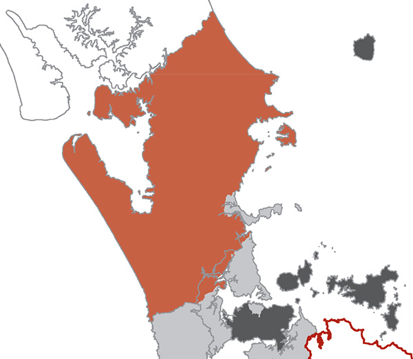
Silted Up: A cartographic mishap on this map of the Rodney Local Council territory proposed by the Royal Commission on Auckland Governance resulted in Mahurangi Harbour being shown as terra firma. While that would have been the natural geographic sequence, anthropogenic sea-level rise will see the harbour, in time, become the Straits of Mahurangi. The royal commissioners’ recommendation was for the vast Rodney landmass to be represented by just seven people; government intervention saw that increased to 10—still extremely poor by European standards—without which Wellsford would probably not had its own representative. map Royal Commission on Auckland Governance
The Royal Commission on Auckland Governance recommendations are essentially excellent news for the Mahurangi.
If Thursday’s Rodney Times had been remotely on the money, the Mahurangi could have kissed goodbye to the care that is being lavished on the catchment. Fortunately the newspaper missed by a country mile, because a rural-based unitary authority would have been too cash-strapped to fund the work needed in the Mahurangi, not to mention the extremely needy Kaipara Harbour.
Some parliamentarians described the commission’s recommendations as a mishmash and Mayor Penny Webster threatened that Rodney district could up-sticks from Auckland.
National Radio and one—or was it both!—major news channels, had the new elected Auckland Council being partly made up representatives of the new local councils.
Given their difficulty with coming to terms with the radically different governance model for the region, it was probably as well that neither major news channel attempted to cover the subject in their respective current affairs slots.
Assuming the government doesn’t suffer a sudden and an uncharacteristic case of the seconds, at next year’s local body elections the people of the disparate Rodney district will elect a new-style local council with a new, Māori name.
Recommendation 16.2 includes:
that each of the six local councils should have Māori names to recognise the Māori heritage in the region and the kaitiakitanga responsibilities of Māori. The commission has been unable to identify a suitable Māori name for Rodney Local Council but recommends that one be identified after consultation with mana whenua.
It is interesting to reflect, that if those interested in the catchment in the earliest stages of deforestation, in the mid-1800s, had been attempting to come up with a name for it, Mahurangi probably would not have been the front-runner. The name would have probably featured Kaihou—the Kaihou Deforestation Initiative, perhaps!
So while a name for the collaborative strategic plan is being agonised over, at least the Mahurangi part has long-since been resolved, organically.
It is hardly surprising that the commissioners failed to readily-find a replacement for Rodney, the district was entirely the monster of earlier, arbitrary local government boundary impositions. Now this is a mishmash, in terms of geography and community of interest. The southern half of the Kaipara is clearly the dominant geographic feature, with far more Rodney District land being in its catchment than any other.
The commission considered a 20-local-council model and an 11-local-council model, before opting for the cheaper expedient of retaining the current boundaries. This, and the temporary retention of its old name, will create a challenge for folk to see the Rodney Local Council for what it is, a community council on steroids.
The tendency will be to compare the new Rodney Local Council with the existing structure, which chaffed under the regional council’s rules, rather than see it the key local engagement component of the new Auckland Council.
It may have been sounder to give it the interim name South Kaipara Local Council.
Speaking of interim names, the following have been suggested for the hope-based Mahurangi network of stakeholders and projects:
- Mahurangi Eco-Initiative
- Mahurangi Environment Initiative
- Mahurangi Initiative
- Mahurangi Initiative for the Future
- Mahurangi Initiative for Posterity
And for the collaboratively-developed strategic plan for the Mahurangi catchment:
- Mahurangi Initiative Strategic Accord
- Mahurangi Initiative Strategic Plan
- Mahurangi Initiative Strategy
- Mahurangi Plan
- Mahurangi Policy for the Environment
- Mahurangi Protection Plan
- Mahurangi Protection and Enhancement Plan
The names that come to be used for the network and the plan may yet to be suggested but often it is those names that resonate with users, and have a certain logic, that become established—a hallmark of the English language, in fact.
Readers will be excused, meantime, if they focus their ferocious intellects on the challenge of replacing Rodney.
Update At the suggestion of Jefferson Chapple, Mahurangi Action Plan was re-cycled as the name of the strategic plan. A draft of the plan was launched on 31 June 2010.