
Conservation volunteers could realise action plan

First Stop: Momentum is building towards completing the long dreamed of walkway between Warkworth and the Wilson Cement Works, which one day will be but the first stop on a network of walkways connecting Warkworth and Waiwera, and Matakana and the settlements on the Mahurangi Peninsula. image Sir George Grey Special Collections Auckland Libraries 1052-P4-15
Forty farm plans completed and 120 kilometres of riparian margin protected.
From those figures, it would be easy to imagine that Mahurangi catchment’s elevated sediment accumulation rate was well on its way to being comprehensively addressed.
Assuming that the riparian margin protected averages 10 metres in width, 2% of the 50% the Mahurangi catchment that is pastureland has been retired. What percentage of the catchment’s pastureland should be classed as riparian management zone doesn’t appear to have been quantified, but the 2% protected to date would equate to only one stream, or ephemeral stream, every kilometre.
To attempt to quantify the challenge from different direction: If the Mahurangi catchment’s share of the region’s 15.4% of land that has eroded or eroding soil was to be planted, at an average spacing of 1.4 metres, more than 10 million stems would be required. At an average cost of $3 for the plants alone, this would be ten times more than the $3 million 5-year kickstart provided by the Auckland Regional Council. Not that the kickstart level of expenditure was about to be repeated by the regional council nor by Auckland Council, its successor.
Comprehending the scale of the task was key to Mahurangi Action’s twin-pronged strategy of slashing the cost of indigenous plants, and advocating for a long-term holistic plan for the Mahurangi catchment. The ensuing council–community collaboration resulted in the Mahurangi Action Plan: A Catchment Plan 2010–2030, which survived intact the subsequent regional governance transition process. An outcome is the Mahurangi Farm-Forestry Trail, and the strong support for it received by the Rodney Local Board and Auckland Council sustainable catchment team staff members.
In addition to the sheer scale of the task to conserve the catchment, was the challenge of attracting sufficient volunteers for the work for which there was no realistic likelihood of receiving funding. In discrete parts of the region, famously at Tāwharanui Regional Park, volunteers trip over each other in their enthusiasm to lavish love and attention on their ‘special place’. But when it comes to corralling a convincing working party to plant trees on private land of a rainy winter weekend, the property holder is likely to get little more out of the exercise than the satisfaction of briefly sharing a hard slog that will continue for solitary weeks long after the city blisters have healed.
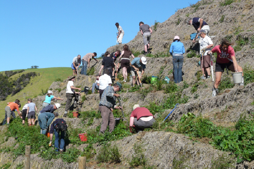
Volunteers by the Hundred: Volunteers have transformed Tāwharanui with more than a hundred turning out for a typical planting day—the 588-hectare regional park is the favourite place for tens of thousands of Aucklanders. The Mahurangi catchment, meanwhile, measures 12 220 hectares—more than twenty times larger, yet a planting day there can struggle to attract 10 volunteers. Cue Conservation Volunteers. image Tāwharanui Open Sanctuary Society
But there is a way in which legions of volunteers are being successfully trained and deployed. Conservation Volunteers is an organisation begun in Australia in 1982. Each year it involves more than 10 000 volunteers to plant a million trees and train 1000 groups and individuals. In 2006, Conservation Volunteers opened shop in Aotearoa. The Punakaiki Coastal Restoration Project exemplifies the scale and collaboration at which Conservation Volunteers excels. In this instance the project partners are the Department of Conservation, Conservation Volunteers, Lincoln University and Rio Tinto—the corporation having gifted the site to the state, continues to provide funding for the project. Conservation Volunteers manages the project, from an onsite office, and provides accommodation for volunteers, who make a payment for the privilege. As a consequence, 80 hectares of coastal land degraded by timber extraction, agriculture and ilmenite mining, walking distance from Punakaiki’s iconic pancake rocks to the north, is well on its way to becoming an eco-tourism gem:
The first goal of the [Punakaiki Coastal Restoration Project] is to create a forested corridor between the sea and the petrel breeding ground, to protect their flight path westward to the sea.
Conservation Volunteers and Mahurangi Action have commenced an exploration as to how a grand partnership could expand the Mahurangi Farm-Forestry Trail into a large-scale legacy project that might see a network of eco-tourism trails extending from Waiwera to Warkworth and linking Matakana. As with the initial farm-forestry section, the trail would seek to showcase sustainable productive forestry that simultaneously created a broad ecological corridor to benefit indigenous flora and fauna. Width matters, when it comes to ecological corridors, which is why providing a productive forestry component for the property holders involved is crucial.
The network would, of course, champion the considerably more cost-effective open-ground (forestry style) method of raising the million or more plants that would ultimately be called for. Indeed there is a possibility that Conservation Volunteers might adopt the method for the nursery it plans to establish in the region. Although it might seem incongruous, it would make perfect sense for a group adept at recruiting serious number of volunteers to be motivated to adopt a less labour-intensive method of raising and establishing plants. The volunteers that Conservation Volunteers attracts are often highly motivated young eco-tourists from Europe keen to make a difference. By training some of these people in best-practice nursery and planting methods capable of addressing the challenge worldwide of countering the effects of deforestation, at scale, suddenly the task of planting 10 million trees in the Mahurangi catchment starts to look entirely realistic. Certainly $6 million for plants, over time, is considerably more credible than $30 million.

Never Rains but it Pours: Modelling indicates that more sediment can be generated in the Mahurangi catchment in a day than in an entire year. The predicted annual sediment load in 1985 was about 11 times greater than in a minimal year, 1991. It is impossible to predict whether a peak sediment year might coincide with the peak earthworks period of the proposed Pūhoi–Warkworth motorway. chart Auckland Regional Council Technical Report No. 018 September 2008
As predicted for more than fifty years, it is during extreme weather events that the contribution of global warming is being felt. Sea-level rise, averaging about 3.2 millimetres per year since 1993—up from the 20th-century average of about 1.7 millimeters per year—goes largely unnoticed until storm surges, themselves augmented by higher temperatures and greater atmospheric moisture content, inundate coastlines. Despite December’s record-breaking storm surge, measured in Hull at 5.8 metres, the mainstream media somehow considers it insensitive to mention global warming’s role in the event. Without barrages such as those that routinely protect London, Warkworth’s town centre will one day be threatened. But the greatest threat faced by the catchment is likely to be from the extreme rainfall events that are projected to become increasingly more severe with rising sea temperatures. Modelling by the National Institute of Water and Atmospheric Research indicates that in a single day during the cyclone of May 1985, more than 40 000 tonnes of sediment would have washed into the Mahurangi Harbour, likely even more than was delivered by Bola.
In short, the Mahurangi urgently needs to be made more resilient to face the extreme weather events projected. Developing a grand Mahurangi walkway stretching from Waiwera to Warkworth, and linking to the Mahurangi Peninsula settlements and to Matakana, could be key to eventually involving thousands of volunteers to plant millions of trees, to turn the dreams embodied in the Mahurangi Action Plan into reality.