
Jade River: A History of the Mahurangi
Ronald H LockerFirst published 2001. Published online 2014–. This online edition is a work in progress…
Pages 9–18in printed edition
How the Mahurangi Harbour got its name
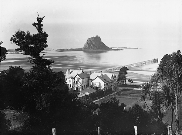
Original Mahurangi: Mahurangi Island, the sea stack, dominates this 1907 photograph by Henry Winkelmann. The Waiwera Hot Springs Hotel burnt to the ground in 1939 and the wharf was dismantled in the 1950s. image Auckland Museum
Mahurangi, the name, belonged to the sea-stack between the mouths of the Waiwera and the Pūhoi, and to the pā that once crowned its summit. Percy Smith, who chronicled the history of Māori occupation, said Mahurangi applied to the small island off Waiwera, but:
…the name has been transferred by the settlers to the harbour to the north of it, the proper name of which is Waihe.
An old lady of Te Kawerau told George Graham in 1918 of an incident at “Mahurangi Island pā—just off the mouth of the Waiwera River”. Reti Roa, in the 1960s, also applied the name to the rock, although he did not know its meaning. The name Waihe was apparently used for the main harbour. It appears as a boundary on Gordon Browne’s land claim for Mahurangi West, dated 1840 at Kororareka. The New Zealand Almanac of 1862 lists Manganui as the “island between Waihi and Kapa branches of the Mahurangi.” A land division map of the 1880s labels the harbour as “Mahurangi or Waihe Harbour”. However, Rawinia Roa, in giving a list of local Māori place names in 1937, attached Waihe to the western head, and gave its meaning as “wrong water”.
The translation of Māori names is made difficult by the wealth of alternative meanings, partly the result of an alphabet of only fifteen letters. In compound names, the number of possibilities multiplies alarmingly. Earlier histories have offered a variety of meanings for Mahurangi, highly improbable even as legends. Falling back on literal translation, the most reasonable choice is ‘rock pointing to the sky’.
Today the eroded rock could no longer support a pā, as it did in the eighteenth century, when it was the fortress seat of Kahikitearoa, chief of Te Kawerau. It seems likely that local Māori would also have used the pā name in a more general sense for the lands immediately surrounding their base, just as today ‘the Mahurangi’ is used loosely to describe the area from the Pūhoi to Kawau Bay. The abandoning of the pā may have helped the process. The earliest Pākehā visitors grasped this broader use of the name and applied it to the feature of most use to them — the harbour. The transfer of name was certainly not the work of the settlers, as Smith suggested. The name Mahurangi was well established on the harbour twenty years before the land sales. In 1832, missionaries Williams and Fairburn were using Mahurangi (spelt thus) in their diaries for the harbour. Likewise, Browne headed his letters to Dacre, 1835–6, with ‘Mahurangi’. Captain Downie of hms Coromandel sounded the harbourhere, and further instances of ‘harbour’, originally ‘River’ for the first time in 1820, labelling it Kyiahou Harbour. He attached the words “Mourangi Rock and Bay” to the Waiwera stack.
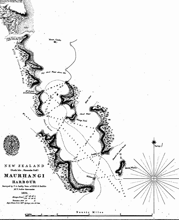
Mangled Māori: On early charts, such as this drawn by First Mate Frank A Cudlip in 1834, and in other early documents, Mahurangi was spelled variously as Mahranga, Mahurangi, Maurhangi, Mourangi, Mourrangee, and no doubt in other forms besides. chart Alexander Turnbull Library
Frank Cudlip, mate of hmss Buffalo, surveyed the first detailed chart of the lower harbour in 1834—published in 1836. He titled his chart ‘Maurhangi Harbour’curiously, two edtions of Cudlip’s chart were printed, identical except is styled “Maurhangi Harbour”, is numbered 1094 and bears the price “Sixpence”, and the other, styled “Kaihow Harbour” is unnumbered and bears the price “9d”—“d” as in denarius: pence. The missionary Yate, passenger on the Buffalo, wrote:
The Bay of Mahurangi — has a fine harbour, named by the natives of the place, Kaihu.
Hodgskin, the purser’s steward, described:
…a lonely and romantic harbour, called by the natives Ki-ya-hou, situated at the head of the Bay of Mourrangee or Mahranga.
It is clear from these accounts that the Bay of Mahurangi had a wider meaning: the bight from Kawau Island to Tiritiri Matangi Island. In fact, the 1853 deed for Motuora locates the island ‘in the Bight of Mahurangi’.
Cudlip attached the name Kiahow to the island at the western head—the Pudding, which Rawinia Roa called Motukahakaha. A sketch map of 1853, drawn by John Sullivan in support of his early land purchase at Otarawhao, also puts the name Kiahou on the Pudding. The New Zealand Almanac of 1862 lists:
Kiahow, the name given on charts to the Mahurangi Harbour; properly the conical rock near the south head.
It seems that the Māori, like the Pākehā, tended to use names for a harbour and its heads interchangeably.
From this tangle, I come to the following conclusions. The name Waihe was used for the main body of the harbour, as distinct from its tributary estuaries. The name Kiahou was used for the harbour, that is for the lower harbour, from around the Buffalo’s anchorage off McElroys to the Saddle. The name belonged originally to the Pudding at its entrance. The name Mahurangi, originally that of the stack off Waiwera, was transferred by the Māori themselves to the immediate coast, its principal river and hinterland. The Bay (or Bight) of Mahurangi meant to early mariners, the enclosed waters from Kawau to Tiritiri Matangi.
It is interesting that my mother’s generation (and her parents’), brought up on the harbour, pronounced Mahurangi exactly as Cudlip spelt it. Cudlip wrote what his ear got from the Māori. The missionaries, fluent in te reo Māori, had the better ear for it.
A novel origin for the name Mahurangi, also along the lines of “rock pointing to the sky”, was given to me by David Simmons. While it appears to be in conflict with the weight of historical evidence above, I am reluctant to ignore such an interesting version from so learned a source. He had it from elders that the name belongs to Saddle Island. Māori believed in two spirit worlds: one below for the proletariat, and one on high for ariki—where their eyes twinkle at night. To collect the spirit of an ariki, a great ghostly canoe would come down from the sky, from the direction of the rising sun. In this case it would swoop into the harbour over the dip in the Saddle, which lies to the eastOriginally, ‘due east’.