
Jade River: A History of the Mahurangi
Ronald H LockerFirst published 2001. Published online 2014–. This online edition is a work in progress…
Surveyor-general consulted character of the land
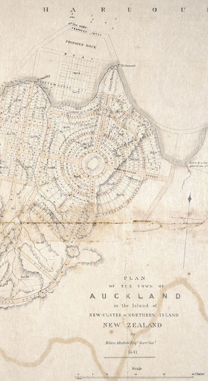
Impolitic and Impracticable: Felton Mathew’s audacious plan for the layout of the capitol of the newly minted colony, and was rewarded by Lieutenant-Governor William Hobson’s support. Although the pace of development swamped Mathew’s health and resources, some of his crescents, or parts thereof, endure. image Sir George Grey Collections Auckland Libraries
Ronald Locker’s dismissive description of Felton Mathew’s plan for “The Town of Auckland”, as “grandiose and impractical”, adds to the unfortunate injustice referred to by editor of the surveyor-general’s journals, Professor James Rutherford:
Since it has become almost customary for commentators since [Dr Samuel McDonald] Martin to wax facetious at the expense of Mathew’s “spider-web” plan, it is only fair that he should be allowed to explain his own ideas on the subject.
Thus, as quoted by Professor Rutherford in The Founding of New Zealand: The Journals of Felton Mathew, First Surveyor-General of New Zealand, and His Wife 1840–1847 :
With reference to the plan of the town, I have to observe, that in the layout of the streets etcetera, I have consulted the peculiar character and formation of the land, a practice which I conceive to be indispensable in the arrangement of new towns, as a means not only of promoting the immediate convenience of the early inhabitants, but of avoiding also the enormous expense entailed on the community, by the necessity which subsequently arises for cutting down hills and filling up hollows, where the streets are laid out in parallel lines, and at right angles, without any reference to the form of the ground.
Guided by this principle, I have in several instances, adopted the crescent form, as one to which the terrain is peculiarly adapted: indeed it could not be made available in any other shape—and its fine commanding position, with a splendid view of the river and harbour will give it a peculiar value as a most desirable spot for private residences; while the lower part of the town will be the most suitable for shops and the general purposes of business.
The portion of the bay immediately in front of the town, included between the two points named (with his Excellency’s approval) Point Stanley and Point Britomart, is dry at low water, and a ledge of rocks extends from either point, which will be found to facilitate the erection of a pier or jetty which may be carried out to such a distance as to admit ships of large displacement to lie alongside for the purpose of discharging cargo. The formation of a quay from point to point will be a means of recovering a large extent of very valuable land, the sale of which will far more than counterbalance the expense of executing these works; which are, in fact, in themselves, extremely simple, and requiring merely a moderate command of labour.
In the present early stage of the colony, and with the paucity of labour from which it is now suffering, I am aware that such works would be both impolitic and impracticable—but looking to this place as the port, and the medium of communication with all parts of the interior of this northern island, I anticipate that at a very early period, the government will find it desirable to carry these improvements into effect, and with this view, I have shown them on my plan.
I should observe that the space between the quay and the jetty will afford a secure and commodious harbour for small vessels and boats, and a means also of their discharging or taking in cargo, without interfering with the larger vessels tying outside.
Felton Mathew’s audaciously creative and geographically sympathetic plan for the layout of the capitol of the newly minted colony, and was rewarded by Lieutenant-Governor William Hobson’s support, contrary to Dr Locker’s claim.
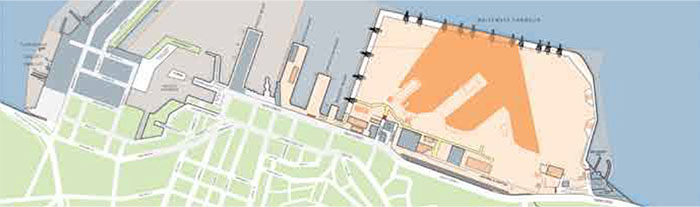
What Sea-Level Rise: With Parliamentary Commissioner for the Environment Dr Jan Wright warning that a further 300 millimetres or so of sea-level rise by 2050 is now inevitable, and only the beginning, the future of the Tāmaki Makaurau isthmus must be more radically re-examined than is evident in this Ports of Auckland ‘Ultimate Port layout’. Note the ghost of Felton Mathew’s circular plan on the form of Shortland Street, Emily Place, and Eden Crescent. image Ports of Auckland
Mathew, meanwhile, was mistaken when he imagined that the main opposition would be to his self-described “impolitic and impracticable” plans for reclamation—Aucklanders took to that part of his plan with alacrity, and then some. It was the prospect of deviating from straight lines and right angles that had critics so horrified. Only a subsequent dearth of surveying assistance thwarted the plan.
An inadvertent legacy of Mathew’s brave plan, aside from vestigial streets and street names, such as Waterloo Quadrant, is Aucklanders’ beloved seven-hectare Albert Park, largely formed from the western quadrants of the somewhat slow-to-survey concentric crescents—in place of Mathew’s town-sized, two-hectare circular one.
Note on addendum Quoted text by Felton Mathew is lightly subedited for clarity and replacement of archaic forms—original text where indicated; text in its entirety is available online at Early New Zealand Books.