
Jade River: A History of the Mahurangi
Ronald H LockerFirst published 2001. Published online 2014–. This online edition is a work in progress…
Pages 61–63in printed edition
Never-to-be-made-official surveyor-general calls

Darkly Elusive: This Caricature of Felton on Lucifer from his wife and cousin Sarah’s scrapbook is one of apparently only two extant images of the man. Most of Felton Mathew’s assignment in Aotearoa was served in ill-health, and ended unsatisfactorily, under Governor George Grey. Mathew died in Lima, en route to England in 1847. image Auckland Libraries
Scribblings in the diaries of missionary visitors have been presented here in full, because although brief, they are valuable records. These transients were too busy to explore or to eulogise during their brief rests at Mahurangi Harbour, in the course of long and arduous journeys.
The first extensive account of the Mahurangi was written for a clear purpose: to report on the quest for a new capital for the colony. It had soon become clear to Hobson that Russell, then located at Ōkiato, was an unsuitable site. Henry Williams had already recommended the fertile but depopulated isthmus at the Waitematā. The governor decided to do the job properly, and so despatched his surveyor-general, Felton Mathew, in the cutter Ranger on 18 April 1840, with a brief to investigate every major inlet between the Bay and the Firth of Thames. This he did meticulously during the next two months, exploring in detail the harbours at Whangārei, Mahurangi, the Waitematā and the Tamaki. On 15 June 1840 he reported his findings to his boss. He recorded his visit to Mahurangi thus:
…having completed my examination of this harbour [Whangarei], and the weather still being very fine with light airs and calms, I proceeded along the coast to the southward and anchored in the bay of ‘Mauranghi’. As there is already in existence a chart of this bay published under the authority of the Admiralty, I need only observe that it is a secure and most beautiful harbour and would afford shelter to almost any number of vessels of any size.
The water appears to be deep closer inshore than is shown on the chart – even outside the heads; there is a fine and secure roadstead open only to the east, and should it blow freshly from this quarter a vessel might run into the harbour, or under any of the islands outside, and be there in perfect security. The shores of the bay are rather bold and elevated, but I do not consider that they present, by any means, an obstacle to the erection of stores, wharves and mercantile establishments, etc.
At the head of the Bay the land presents a very inviting appearance, rising gradually from the water in gentle undulations, and covered only with fern, but as usual the tide ebbs to such a distance from the shore as to render it quite unapproachable.
Proceeding up the River which enters the harbour from the NW, I found that it affords a fine channel, in the narrowest places 20 to 30 yards wide, having a uniform depth of two fathoms at low water, for about five miles.
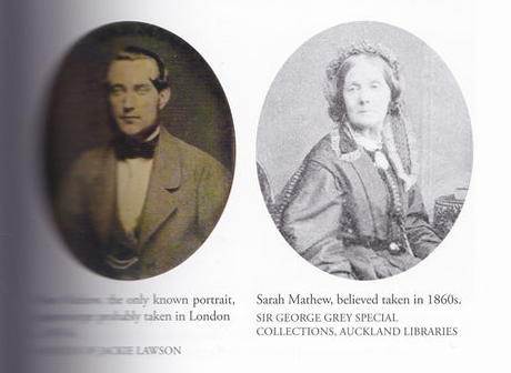
Cousin, Wife and Diarist: In contrast to the elusiveness of Felton Mathew’s likeness, is this of his cousin and wife Sarah Louise Mathew. She refers to “my beautiful horse Lucifer, which was quite a pet”, and Governor Hobson’s wife mentions a foal by the Mathews’ Lucifer. image Sir George Grey Collections Auckland Libraries
The left or northern bank is lofty and difficult of access, the southern much less so, but its base is skirted by mangrove swamps which render it unapproachable for three miles from the mouth. The hills on both sides are covered with Kowdie in the greatest profusion, down even to the water’s edge. There does not seem to be any quantity of this valuable timber of sufficient size to be available for spars, but there is an abundant supply well adapted for house building and domestic purposes, and a vast number of young trees which in a few years cannot fail to become valuable. About five miles from the mouth there is a fall of about six feet, and at this point the river ceases to be navigable and separates into three branches, each affording a large and apparently unfailing supply of fresh water. Above the fall, the ground rises in a succession of gentle and beautiful undulations covered only with fern to a lofty wooded range in the NW which undoubtedly divides these waters from those which flow into the Kaipara. To the north I could see a range diverging from this and apparently extending to Omaha Bay. Westward and southward another diverging to Wangaproa, thus entirely surrounding the harbour of Mahurangi, and its tributary water, and forming a beautiful little amphitheatre of about ten miles by five or six, in which the spurs from the principle range are most picturesque, perfectly free from trees, with the exception of occasional patches of forest, abounding in Kowdie and affording an excellent supply of fuel. The whole of this land is perfectly available, and affords a very fair proportion of fertile soil; the magnificent slopes of the hills are admirably adapted for the site of a town, and the supply of beautiful fresh water in every direction is inexhaustible. For about a mile and a half below the fall, the right bank of the river is well adapted for building, being but slightly elevated above the water and rising gradually to the ranges in the background. There is also a good depth of water close in with the bank. Brick earth is abundant, and the forest in every direction presents a profusion of timber for building, almost entirely Kowdie. The river is perfectly adapted for navigation by steamers or small vessels; and the harbour forming the depot for shipping being at so short a distance I consider the spot I have described as being most admirably adapted for the formation of a town. It is evident that communication might be opened, westward with the Kaipara and the west coast, and southward with the Waitematā and Manukau; and although it is probable that access would encounter difficulties, yet I do not consider these to be insuperable, or to disqualify the place for the seat of government if no better spot can be found.
I am fully aware how desirable it would be if a spot could be selected, affording good anchorage close inshore, and sufficient extent of land for the erection of a town on its immediate shores, regard being had to facility of communication with the interior by land or water. But such advantages do not anywhere present themselves in combination and large navigable rivers it is evident from the formation of the country, cannot exist on this coast.
Although therefore, Mahurangi does not by any means present so many advantages combined as I should consider desirable, yet on the whole it enjoys more than any I had hitherto visited.
My chief objections are that it is rather limited in extent, internal communication would be rather difficult and its position is somewhat too far northward. Under any circumstances however, I would suggest that it would be highly desirable that the Government should obtain possession of this harbour and a considerable proportion of the surrounding country. A settlement once formed here, would I have no doubt, rapidly attain a very flourishing condition. Several Europeans lay claim, I believe, to this portion of the country, but their titles, I am informed, are of no value. And even among the native chiefs a dispute exists as to the rights of ownership. The government should therefore have no difficulty in taking possession of it. I did not see the slightest trace of native inhabitants during the time I was in the place.
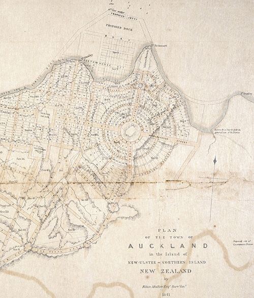
Circularly Challenging: Derided at the time—‘there is not a single square house in the whole settlement’—and by Dr Ronald Locker here—‘grandiose and impractical’—Felton Mathew’s plan for ‘the town of Auckland’, with work, might have resulted in one of the most beautiful city centres in the world, centred, more or less, on what is now Albert Park. image Sir George Grey Collections Auckland Libraries
Mathew’s judgement seems a little optimistic, but he would have had in mind some modest centre for an outpost of empire, and no conception of the town we know as Warkworth. However, when his survey continued southward, the Mahurangi was quickly struck off. He opted for the Tāmaki, but Hobson, a mariner, was unimpressed with the bar across its mouth. Sensibly, he chose the Waitematā, but so earned the enmity of his surveyor-general. Relations were not improved by the rejection of the latter’s grandiose and impractical layout for the town.
But Mathew kept the memory of the beautiful Mahurangi filed in his mind. In August 1842 he accompanied the governor on his only visit to Port Nicholson, where the frustration of the company settlers was reaching boiling point. Hobson had an icy reception, and was socially snubbed, as were his retinue. Jerningham Wakefield referred sarcastically to “the three epaulet Surveyor-General”. Among the complexity of problems that confronted Hobson was the urgent and unresolved matter of choosing a site for the New Zealand Company’s new settlement, already named Nelson. Settlers were already in passage, and payment for land, unspecified, had been made to Te Rauparaha. The governor, whose meagre resources were overstretched in extending government to Wellington, was unwilling to permit colonisation of the ‘Middle Island’. When Colonel Wakefield asked him to point out a site fit for the colony, Mathew produced a map:
His Excellency suggested a place called Mahurangi, situated about fifty miles from the capital at Auckland.
Negotiations continued in uncordial tone, and:
…his Excellency declared with some warmth that he would “not colonize New Munster.”
Heaphy, surveyor for the New Zealand Company, who was there, wrote:
…nothing would have induced Captain Wakefield (company agent for Nelson) to plant the colony on the place pointed out, where it would have been continually suffering from the rivalry of the adjacent government town, which would soon have drained the place of its working population, brought out at the expense of the landowners of Nelson; while the added circumstance of Auckland possessing a tolerable harbour would have always caused its pre-eminence over the adjoining township.
Shortly afterwards Nelson Haven was discovered behind the Boulder Bank, and the die was cast: Mahurangi never became Nelson. The rivalry that exists today between Auckland and Wellington, the town that finally triumphed as the capital, is a pale thing compared to the sheer venom of relations revealed in those old records. Heaphy of course was right. The carefully preserved English class structure of the New Zealand Company settlements would not have lasted long on the Mahurangi, and the capital of the day would have overshadowed it, as he had shrewdly suggested. Nelson did much better from being where it is.
Heaphy was destined to survey the rejected site a decade later, for a more egalitarian form of settlement.