
Plan for Mahurangi a million miles away


Overlooked or Lost: Charles Heaphy left a wealth of heavenly watercolours of Aotearoa but only this rough sketch of the Mahurangi, his one-time home, has ever come to light. sketch Charles Heaphy Jade River: A History of the Mahurangi
For the first time in more than 150 years, the Mahurangi is about to have a plan.
But it won’t much resemble the last one, which was essentially a subdivision to form ‘Mahurangi Township’. Charles Heaphy vc supervised the survey, and such was his enthusiasm for the plan, he bought 13 of the 280 one-acre lots himself.
The township never materialised beyond a few dwellings, including Heaphy’s own in Schoolhouse Bay. Subsequently, so unlikely did it seem that the lots would ever be used for residential purposes, the homestead in Te Kapa Inlet was built straddling the boundary between two of them.
Today’s Mahurangi Action Plan reflects a very different vision for the harbour than had Heaphy and his Auckland Province masters. The immediate driver is the need for integrated catchment management, to better address the harbour’s elevated sediment accumulation rate.
This follows five-year’s work initiated by the regional council, which closely focussed on riparian protection—the fencing and planting of stream margins. The intention of the five-year plan had been to kick-start a response by the local council and community to 10 years of science that showed the harbour was going to hell in handcart.
At the end of the five years, the regional council acknowledged that long-term commitment was needed, and resolved to collaboratively develop a strategic action plan. But, after a nine-month gestation, the draft action plan now desperately needs the sparkle and detail that reflects the long-held aspirations of Mahurangi enthusiasts. The Mahurangi Magazine conceived the following tour of the Mahurangi, such as might be laid on for councillors and officers of the new Auckland Council, following its first election, as a way of introducing that sparkle. The Mahurangi Magazine asked writer of the plan, Boffa Miskell, that the itinerary, its articles already devoted to the Mahurangi Action Plan, summarised below, be considered feedback on the draft document.
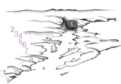
The tour begins by travelling along Mahurangi West Road, from State Highway 1. Having climbed the hill to the Mahurangi West ridgeline, the coach briefly pauses for the guide to emphasise the harbour’s single most valuable attribute—the sense for sailors of being a million miles from the metropolis. But also to lament that lightspill from Snells Beach has eroded that sense of solitude—even in the daytime, and 9.5 kilometres distant, the ‘red shed’ obtrudes.
Mahurangi: A million miles from the metropolis
- Preserve the sense of being a million miles from the metropolis, by protecting the night sky
- Recognise that the scenic ridge roads are as important as the regional parks they serve
- Further-develop the Mahurangi West scenic ridge road study
- Apply to restrict speed on scenic ridge road to 70 kmh
- Progressively develop walking and cycle trail within road reserve
- Support completion of Mahurangi West Hall and marquee site project
First Glimpse: Most get their first glimpse of the harbour while on their way to the Mahurangi West Regional Park, by car. Rendering Jefferson Chapple
The Mahurangi West Hall is the perfect venue to combine a stop for coffee and muffins (baked fresh by the Great Dessert Co. Café, which the tour bus has just passed) while watching Mahurangi Action Plan: Weaving Science and Community into Action.
In addition to viewing Craig V Powell’s documentary, three charts are displayed that demonstrate the specific threats posed to the Mahurangi by global warming. Thus three principal threats hang over the Mahurangi—one global and two local:
- Anthropogenic global warming
- Elevated sediment accumulation rate
- Residential use of harbourscape of outstanding natural beauty.
Inescapably, the greatest threat is global—anthropogenic global warming. James Hansen calculates that if the current policy of combusting all available fossil fuel persists, a runaway greenhouse effect will ensue, which would ultimately extinguish life itself. But even with the degree of global warming that has occurred to date, heavy rainfall events are more extreme and more frequent, as a result of a 4% increase in water vapour. The science clearly shows that the bulk of sedimentation in the Mahurangi catchment occurs during a few extreme rainfall events.
Meantime, accelerating sea level rise will result in increased sediment generation, particularly as rock platforms progressively provide less and less protection for the soft, readily-eroded shoreline.
The Mahurangi catchment is very well studied and it is evident that its benthic communities are under increasing stress. The probable cause of this stress is an elevated sediment accumulation rate, making it appropriate that measures to conserve soil and enhance riparian environments should be a catchment priority.
The outstanding natural beauty of the Mahurangi harbourscape is unexpected, given its proximity to the metropolis. It is the singular asset in a strategy to restore and the harbour’s sediment-degraded waters.
Plans for the Mahurangi catchment first need to be tested against these three threats. Crudely, however, the response to all three is the same: More trees.
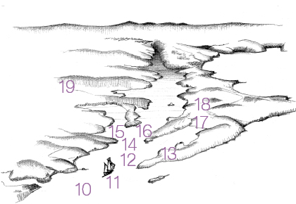
The next brief stop is at the ‘Locker Lookout’ but at other potential lay-bys the coach has been unable to pause—it would have blocked the road creating a hazard.
- Develop the ‘Locker Lookout’ at the lay-by overlooking Huawai Bay
- Further-develop the lay-by and lookout at Tungutu Point
- Mahurangi – Waiwera coastal cycle trail
- Investigate an electric ferry service to link the parks and communities on either side of the harbour
Lucky Few: The most memorable first impression of the Mahurangi Harbour is only experienced by the minority with the privilege of arriving by sea, rather than by road. Rendering Jefferson Chapple
Tungutu Point necessitates another stop and a short walk—this is the singular Mahurangi Harbour vantage.
The lookout ‘floats’ fifty metres above Mita Bay and is the point from which Philip Kilmore’s Mahurangi is painted. With views south to the bluff between Waiwera and Wenderholm, it is the perfect place to extol the possibilities of the coastal cycle way.
It is also an opportunity to confess to the tour party that while the scenic ridge road is a fine introduction to the Mahurangi, the ultimate is to approach the harbour by sea——under sail——at dusk——the Friday night of the regatta.
From Tungutu Point it is to Sullivan Bay, and aboard the Jane Gifford.
- Preserve the sense for sailors of being a million miles from the metropolis
- The Jane Gifford to serve as flagship for the Mahurangi Action Plan
- Operate the Jane Gifford as a floating classroom for young people to study the Mahurangi river, harbour and catchment
- Plant the shoreline, over time, with a progressively broadening band of pōhutukawa and other indigenous species to increase resilience to sea level rise
- Mahurangi Regatta as a coming together of regional and local community, and its council
- Create an all-tide landing at Mahurangi West
- Develop Scotts Landing as wedding and regatta venue
- Fence and plant shoreline margins, where adjoining land will be grazed long term
- Fence and plant stream margins, where adjoining land will be grazed long term
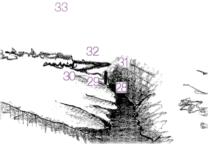
Great View From the Top: Or it would be, if a viewing tower was built atop the Dome from which to view the Mahurangi catchment. Rendering Jefferson Chapple
- Clothe the steeper hills in indigenous forest—produce high quality timber, not concrete and steel
- Clean up the derelict oyster farms
- Clean up the water for the oyster farms
- Enhance Dawson Landing and build the walkway to Goodall Reserve
- Create a marine farmer shore depot
- Create a town basin for Snells Beach
- Chart, mark and strategically dredge the Mahurangi River
- Long-term plan a Warkworth – Snells Beach walkway network
- Develop a public landing at the Wilson Cement Works
- Complete the Warkworth – Wilson Cement Works walkway
- Cease using the Mahurangi River for the disposal of Warkworth’s wastewater effluent
- Protect Warkworth’s river backdrop of indigenous forest
- Further develop the Warkworth Town Basin
From Warkworth, the tour goes overland to the Dome, the top of the catchment.
Unfortunately, neither the misnamed Top of the Dome Café—it isn’t, but one could well be, with 360° views—nor the Dome itself, for want of a vantage, provide comprehensive vistas of the catchment.
- Develop a viewing tower on the Dome.
When the coach passes Moirs Hill, on its way back to the metropolis, the top of the Mahurangi River south branch catchment should be saluted.
And the visitors urged to see the Mahurangi Magazine for a more detailed exploration of these Mahurangi visions, gaols, projects and actions.
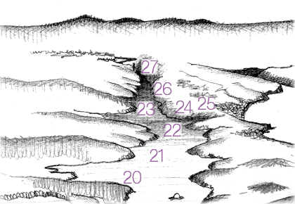
Where it Gets Difficult: Where the harbour narrows into the Mahurangi River, the effects of the elevated sediment accumulation rate become manifest. Rendering Jefferson Chapple
Suggested Responses
Harbourscape
The universal reaction of first-time visitors to the Mahurangi is ‘This must be Auckland’s best-kept secret; what a pity it’ll end up like Whangaparāoa.’
The fatalism is unwarranted, but without a vision for the Mahurangi it could fuel a self-fulfilling prophecy. Neither locals nor the regional audience wish to see the harbourscape dominated by buildings. The district plan has—at least it has since the mid-1970s—had the bulk of the harbourscape predominantly in rural, rather than residential zones. The regional parks ensure that the landscape of the heads of the harbour is strongly protected. The singular lack, has been of a clearly stated vision.
Landscape protection is ultimately more imperative than the elevated sediment accumulation rate, which can be remedied long term. If the harbour was to lose its largely uninhabited look and feel, it is inconceivable it could ever be regained.
Actions include
- Possible adoption of Rotorua Lakes Zone A –style screening of buildings as viewed from the water.
- Further develop the council development guide to better protect landscapes of outstanding natural beauty.
Scenic ridge roads
To quote Jade River : A History of the Mahurangi:
Of the many scenic byroads in Rodney, the two most important are those that wind along the ridge tops to give access to Mahurangi West and East. They have assumed new significance as entries to the regional park.
The most used, as the nearest access from the city, and the most at risk, is Mahurangi West Road (including Ngārewa Drive). If I seem to give it undue attention it is because I know it well and see it as the prime example of threats that apply to other places in the area as well.
It has always been a very special road that marked the transition, in four miles from the busy highway north to the peace and out-of-this-world beauty of the estuaries. For years a muddy track, it kept at bay the motorised pleasure-seekers of the city, so saving the Heads for a future regional park. Now it is destined to serve as the principal gateway to the park. It is the strip of land that residents see most often; it affords the first impression for visitors.
Rising quickly to the highest ridge, it begins to unfold magnificent panoramas of the Gulf: from Whangaparāoa to Moehau and Little Barrier. Looking northward the eye is mystified by the apparent complexity of the estuarine waterways; beyond, the Dome ridge and Tamahunga rise as a green wall.
This road is a scenic asset in its own right. It is as important as the regional park it serves and should have about six lay-bys where visitors could safely drink in the scene. These would serve also to emphasise the values of the road.
This eulogy for the scenic ridge roads, and for the landscape generally, was the only advocacy that Dr Ronald Locker included in his 416-page history—aside from a mention of adventitious species. Only those who knew the man can possibly appreciate the extent of his restraint.
Actions include
- Further-develop the ‘Locker Lookout’ above Huawai Bay
- Develop other ridge road lay-bys
- Incrementally develop walking paths, including to minimise exposure of walkers to vehicles.
- Revisit/implement 2004 Mahurangi West Road – Ngārewa Drive management and enhancement study, which was commissioned by the community and paid for by its local council.
Climate action showcase
The Mahurangi Action Plan is billed as a strategic plan for the next 25 years, building on the strongly science-based five-year action plan.
A 25-year plan cannot credibly ignore global warming science, particularly as the catchment is prone to impact by heavy rainfall events and its shoreline to the effects of accelerating sea level rise.
While its proximity to the metropolis makes the Mahurangi a potential showcase for climate action generally, the need for a strong strategic focus suggests that actions that favour soil conservation, and harbourscape protection, or concern agricultural emmisions, should be prioritised.
The natural resilience of the coastline can be increased by planting with appropriate indigenous species. These include pōhutukawa and, on the sandy beaches, the sand-binding plants pīngao and spinifex. This strategy is far more cost-effective, and sustainable, than armouring. Armouring should only be seen as a short-term expedient—accelerating sea level rise makes managed retreat the default strategy.
The readily-erodible soil and steep terrain of much of the harbourscape dictates that tree cover should be maximised.
Indigenous forestry best addresses carbon sequestering and soil conservation needs. It also makes the greatest aesthetic contribution to the harbourscape.
The successful open-ground indigenous plant project was the community’s response to the realisation that while the establishment of millions of indigenous trees—20–40 million for riparian margins alone—in the catchment was highly desirable, the cost of plants was a serious impediment.
Conversion to forestry frees up available riparian fencing funding for that land that is suitable for long-term pastoral use.
Possible actions include
- Maximise use of open-ground plants to help drive down cost of plants long term.
- Establish indigenous forestry trial and demonstration blocks.
Work in progress
In 1975, Mahurangi Actionthen known as Friends of the Mahurangi drafted a fifty-year plan for the harbour and proffered it to the local council. It was ignored. The current corroboratively developed Mahurangi Action Plan should be seen as a starting point, rather than the gospel. It is to be hoped that the new regional council and the wider Mahurangi community will continue to further meld it into an even more faithful reflection of the broadly-held hopes for the harbour.
Likewise, this ‘ever-so-slightly longer tour’ of the harbour is a work in progress, and will continue to evolve.
Publisher’s note This article is an amalgam of two that were published separately—‘a short tour’ and ‘a slightly longer tour’—combined here to avoid the general undesirability of duplicating content, and invoking that sinking ‘I’m sure I’ve read this before’ feeling.
Warkworth, 50-yr-old architectural student interested in sustainability. Great to see communities getting on the same page and having a plan.